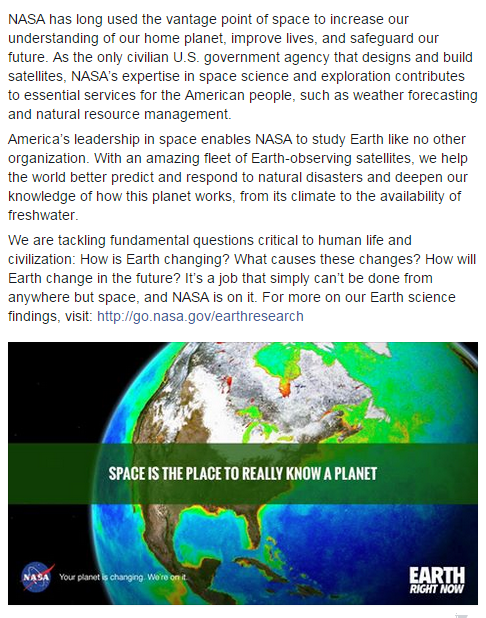
Earth Science Research from Space

2024
March

On March 4, 2024, MethaneSAT detached from the SpaceX Transporter-10 rocket that carried the emissions-monitor into space.
The groundbreaking satellite is designed to help protect the Earth’s climate by accelerating reductions of this powerful greenhouse pollutant, focusing on oil and gas operations, a major source of methane.
MethaneSat data will become available, it has been announced, for download in the Google Earth Engine database...
MethaneSat is the first satellite developed by an environmental non-profit and enables emissions tracking and business accountability. The net result -- faster reductions of methane gas.
Climate Action Plans 360
Distributing the data is the next step ...
GRN360: Climate Plans Enforcement Initiative
GRN3360: Methods to Enforce Climate Plan Pledges

🌎
February
February 7, 2024 / The following image from the Copernicus, EU satellite system is a post from Ron Merkord, a graduate of CalTech.
Our GreenPolicy360 Planet Citizens community is proud to call Ron a friend.

Dreaming of Global Open Source Earth Imaging
- A 'Before & After' Story
Siterunner/GreenPolicy360:
In the 1960s, as the environmental movement came into the imagination of many young people across the United States, in East Los Angeles, my new Congressman and friend, Representative George E. Brown first told me of his dream to bring Earth Science, especially via Earth imaging/observation programs, to the world. He spoke of 'open science', and new digital imaging. At GreenPolicy36 we have written about this period and brought into the light a woman who literally invented the first multispectral imaging scanner for satellite viewing of the Earth. Rep Brown was a central figure in the start-up of the NASA Earth Science programs (and went on to shepherd them along as flocks of satellites became what we have today, a constellation of Earth Observing satellites and systems.
Back in the day before there were any Earth Science satellites, there was a dream, a dream of Earth Science satellites and a dream expressed off and on to a young high school student in the Congressman's district. As I look at the image of the Pyrenees and the effects of climate, taken by a spectral system in a Earth imaging and mnonitoring satellite above, I think it is a good time to look back and recall a Congressman's dream.
I was at Cantwell High when I first met George Brown, and I was beseeching (yes we used words like beseeching in the olden days) to help me by giving me insight into the government's policies that were threatening life on Earth. Nuclear proliferation was that early 60s debate topic in California schools. This was soon after the Cuban Missile Crisis and the 'close call' where kids were 'ducking under desks' as 'sirens blared' in prep for a nuclear missile attack. The missile crisis was narrowly averted, as history later how near the world came to the precipice and, as students, we debated how to deal with the threats.
George Brown was, soon after entering Congress, a leader in space and technology. He was a trained in physics, and an engineer who entered politics to make a difference. His district/our district extended into the San Gabriel Valley and, listening to George as I complained about the Jesuit students at Loyola High being my debate nemesis, George talked about Pasadena, where Loyola was located. He talked about how Pasadena, and Loyola, and CalTech and JPL. The California Institute of Technology and Jet Propulsion Laboratory were new to me and he explained how they were among the best higher education, science and applied engineering hubs in the nation, and world. He also explained how they were going to be the core of his dream to bring Earth Science via science, technology and new NASA Earth Science programs into reality. Considering he now had the ways and means to do so, with his position in Congress, I believed him and, for 30+ years was a young friend and later colleague as he went about the business of proposing, developing, launching and managing a first generation of Earth imaging/observation programs that became a foundation for all.
Today, George Brown is known by some for his work to get the Landsat program going, a first of its kind in Earth Science, a program now in its fifth decade, a program that has uniquely captured a vast, dynamic/taken over time, invaluable data set of Earth images. The Landsat program has, as George pushed to engineer, developed an increasingly capable scanning system circling our Planet Earth.
Let's look closer. George was right about the money invested in CalTech and JPL, stars in a NASA public/private partnership, as some of the most famed and awarded scientists, teachers, graduate students, engineers, and visiting professors brought state-of-the-art science to people of the world. George was pushing 'open source' before the Internet was talking and developing 'open source' code. He was prescient in seeing the value proposition of the tools we were developing as enablers of environmental protection, and a gift for future generations. He had to argue constantly with the military, who attempted to keep many of these tools and systems confidential for security reasons. but in many cases George prevailed... and the systems were released into the public arena, and scientists and educators and students everywhere saw with new eyes the beauty and challenges we were experiencing as 'Generation Green' as the Whole Earth came into view.
Take, for example, the scanning and consider how it developed, version by version to today from the original Landsat multispectral system.
Spectral Imaging
Multispectral imaging to Hyperspectral imaging (spectral imaging / imaging spectroscopy) to Full Spectral Imaging (improving Earth remote sensing capabilities)
- https://en.wikipedia.org/wiki/Spectral_imaging
- https://en.wikipedia.org/wiki/Multispectral_imaging#Applications
- https://en.wikipedia.org/wiki/Hyperspectral_imaging
- https://en.wikipedia.org/wiki/Full_spectral_imaging
Now let's look at how these systems, designs, com systems, digital imaging, analysis (measuring and monitoring capabilities were (and are being) shared with and employed by European space science, especially as the nations of the world deal with Climate Change and now continually gather facts and data with which to utilize to make wise decisions. The data is needed George said, we have to go get the information we need to have. George Brown then drafted the first US National Climate Act back in the 1970s. His dream was to give us the tools to build on, a foundation of 'Big Science' to put to work to help future generations community-by-community, nation-by-nation.
Even with the pressing challenges we face in these times, I think George would be pleased if he were still here in person.
In a way George E. Brown is still here. 'Eyes on Earth' science, shared with all, carries on the mission.

Look at how thin our atmosphere is

NASA

🌎

🌎
The International Space Station
- Continuing the Earth Science Mission from Near-Earth Orbit
- The ISS maintains an altitude between 220 - 286 miles (354 - 460 km) above the Earth, and orbital inclination of 51.6˚,observing most populated areas of the world.
- https://eol.jsc.nasa.gov/Collections/
- https://eol.jsc.nasa.gov/SearchPhotos/
- https://eol.jsc.nasa.gov/Tools/
🌎
Landsat, the Longest-Flying Earth Science Mapping Mission
- https://www.greenpolicy360.net/w/Landsat_data_users_handbook
- https://www.greenpolicy360.net/w/LANDSAT_and_Virginia_Tower_Norwood
- https://www.greenpolicy360.net/w/File:Multispectral_Scanning_Systen_-_MSS.jpg
George & Virginia: Their Vision Is a Profound Legacy
GreenPolicy360 Siterunner Steve Schmidt: Back in the 60s and 70s, my friend George E. Brown was a key force in the U.S. Congress creating a first generation of earth science missions from space, remote imaging it was called. I was fortunate to have become close to George and his work as we each, in shared politics and initiatives, attempted to advance environmental protection and the science necessary to 'measure, monitor and manage' earth's systems. George was often called the father of the Landsat mission and its programs and in his role on the government's oversight committee in the House of Representatives, and a Chairman of the Space, Science and Technology committee over decades, Congressman Brown worked to set in motion a constellation of earth science research programs. One his collaborators with Landsat and its pioneering studies, research, data and unique digital databases of knowledge was Virginia Tower Norwood. Together George and Virginia, can be called the father and mother of Landsat and earth science imaging that is a generational gift enabling us, today's generation of scientists, the public and political/educational groups around the world and NASA/NOAA/USGS and international science and space programs to manage earth's living systems.

🌎


- "Everything on Earth is Connected"

🌎

Earth Science / Earth Observing System
The Original NASA Mission Statement
50+ Years of Studying Planet Earth
Steven Schmidt, GreenPolicy360 Founder: In remembrance of George E. Brown, a special person and Congressional Representative from California who brought a physics and engineering background his three decades of leadership to environmental earth science programs created on his watch. George saw what others didn't really understand and when he showed me the original Mission Statement of NASA, I began to understand. Here is the key phrase again -- “To understand and protect our home planet..."


The Earth Observing Fleet of Satellites
GreenPolicy360 / Steven Schmidt: In the late 1960s I first discussed environmental protection, engineering and politics with my newly elected Congressman from East Los Angeles. At the time I was a high school student on the debate team and that year in California debate topics centered on nuclear weapons and proliferation. George E. Brown, my district's representative, was trained in physics and engineering and was writing about international dangers of war and nuclear disaster, so I thought I'd meet with him and ask for his assistance in my debating research work. George and I began what became a long journey. In many ways George was my mentor and I believe he saw in me my generation's hope and youthful energy as we worked together. I was an activist/educator and professional whom he trusted in and with whom he could share his thoughts and agenda.
Until George's passing in 1999, I was fortunate to see inside what became the U.S. earth science space missions and beginnings as a visionary man took on the the great questions of our era. From atomic issues of deep science, energy, war and peace, the need for environmental protection, and climate research, all George's work was focused in the 60s/70s/80s and 90s in Congress as a Chairman and leader of budget/policy and oversight of these new challenges. George Brown's life faced the big issues of the nation and world. I saw up close the vision, goals and plans that George was putting into practice.
Earth Science Research from Space, that is, measuring and monitoring Earth Systems, Earth's living systems, was front of mind in the world of George E. Brown.
GreenPolicy360 and I have been tracking George's history and memory. Do read about this generational journey and feel free to share with your networks.
Some of the latest work from programs George was responsible for proposing, drafting enabling legislation, shepherding passage and presidential signatures approving the missions are now, some 50 years on, producing unique data that scientists are using to reveal and intelligently respond to our pressing 21st Century challenges and George would be more than please if he were here to see the vision, goals and plans in full realization.
The Earth Information Center is one of the more recent reveals. It is an amazing online open-source database. Open it up. Surf around (as we used to say in Southern California). The vision of our world, our planet's living systems is a gift to know, share and use to protect and preserve life, and quality of life. As planet citizens our responsibility is to step up and do our best to make a positive difference during each of our lives.
Earth Science Research from Space is yours now.
More on George E. Brown:
🌎

NASA

Eyes in the Sky
(Remote imaging of Planet Earth circa 2022)
Google Earth
Bing Maps Aerial
Mapbox Satellite Live
HERE WeGo - Map View / Satellite
Zoom Earth
···························
Airbus
Capella
EagleView
Hexagon Geospatial
ICEYE (US)
Maxxar
Nearmap
Planet | Planet API
- https://www.planet.com/
- https://developers.planet.com/docs/data/skysat/
- https://earth.esa.int/eogateway/missions/skysat
Spire
Vexcel Imaging
🌎
Time for Planet Citizen Action and a "CEOS", a Committee on Earth Observation Satellites
GreenPolicy360 welcomes the arrival of a global science mission, a "Global Stocktake", a collection of earth science data to be made available to the community of nations, to planet citizen activists and scientists, educational institutions, non-profits, NGOs, young and old to become tools for legal enforcement of national climate plans & pledges.

* https://www.greenpolicy360.net/w/File:Global_Stocktake,_the_first_GST.jpg
What is a "Global Stocktake"?
The global stocktake is a critical turning point when it comes to efforts to address climate change - it's a moment to take a long, hard look at the state of our planet and chart a better course for the future.
The Global Stocktake is a participatory, inclusive and transparent process. It consists of three main phases taking place over the course of two years: Phase 1: Information Collection and Synthesis This first phase is underway.
- https://unfccc.int/topics/global-stocktake
- https://www.wri.org/insights/explaining-global-stocktake-paris-agreement
- https://climatechampions.unfccc.int/what-is-the-global-stocktake/
See GreenPolicy 2021 initiative for Legally Enforcing National Climate Plans
Visit GreenPolicy360's "Climate Plans Enforcement" (Project-in-Dev 2021-2023)
- "Turning National Climate Pledges & Promises into Reality"
🌎


🌎
NASA Earth Science Missions
EOS
- Earth Observing System
GreenPolicy360 siterunner: Remembering a first generation visionary who worked over decades to create a system of earth science through a multi-satellite missions
The Earth Observing System (EOS)
The mission of the Earth Observing System is a core element of the ongoing NASA earth science programs first envisioned and set in motion in the 1970s. The constellation of satellites that now comprise a connected matrix of ongoing earth imaging programs (see the latest here) came about as the U.S. Congress realized in the years following NASA's establishment that Planet Earth was central to NASA's work. The initial NASA mission statement spoke of this study of Planet Earth as a key goal of NASA programs. A new science, space and technology Congressional Committee was created to envision and oversee these programs and one of the first realizations about the need for earth science came about through the LANDSAT program (see here). A historic moment brought into existence digital mapping, that is, multi-spectral imaging of earth from an orbiting satellite in space, envisioned and designed to collect and 'save' data of earth's living systems. This databank was considered to be essential by committee member George E. Brown who, as a physicist and engineer, began his three-decade + career in Congress. George eventually became known for his "big science" initiatives. What few knew back then at the beginning was how essential this data would become as climate science came into the light (in 1977 and '78 with George's work central to the drafting and passage of the first National Climate Act.)
In the 1980s, the Earth Observing System (EOS) work began in earnest.
NASA's Project Science Office years later described its beginning with this statement:
>Results from early missions shed light on critical components of the Earth system while prompting further, more advanced investigations. The NASA Earth Observing System (EOS) program was conceived in the 1980s and began to take shape in the early 1990s. EOS is comprised of a series of coordinated polar-orbiting satellites designed to monitor and understand key components of the climate system and their interactions through long-term global observations. The EOS missions focus on the following climate science areas: radiation, clouds, water vapor, and precipitation; the oceans; greenhouse gases; land-surface hydrology and ecosystem processes; glaciers, sea ice, and ice sheets; ozone and stratospheric chemistry; and natural and anthropogenic aerosols.
NASA's Earth Observing System (EOS) Reference Handbook
In June 1992, the National Space Policy Council issued National Space Policy Directive and EOS became part of a global change observation system.
Continuity of satellite missions gathering data over years established what is known as a longitudinal trendline of observations, the goal set forward in the late 1970s and 80s with LANDSAT, weather satellites and many others in the first generation of environmental science research with space-based remote imaging. This long vision would empower scientists and others to measure and monitor dynamic changes over time, a critical factor in enabling policies to be drafted to manage earth's systems. George Brown was a key factor in these decisions. He saw, as did your GreenPolicy360 siterunner who was following his work through the years, that data and sharing of data would build educational resources, science and new opportunities. Previous military intelligence programs from space, for example, were revisioned/rethought and ideas such as a Global Positioning System GPS with all of navigational potential on earth came into being under President Reagan in the 1980s. Later in the 1990s under Democratic administration the Next Generation Operational Control System acted toward increasing GPS positional accuracy. New mapping and navigation tools, now in most all new cars, were results of these programs that George Brown helped set in motion saw coming into existence before his passing away in 1999.
The Terra satellite, the first of 26 satellites that have orbited or continue to obit as a formal part of the EOS progam was launched on Dec. 18, 1999. Terra (originally known as EOS-1) was designed for a five-year mission life, but continued to orbit for more than another decade.
George was alive as the launch of the Terra EOS program happened in December 1999. He knew that his mission, his work, was continuing on as a legacy.
Again, we at GreenPolicy360 tip our hat to the vision of Planet Citizen George E. Brown, a generational thinker and doer, mover and shaker...
All the Missions -- https://www.nasa.gov/missions
In 2020, a new Observatory with a climate mission focus within the Earth Science NASA Mission
🌎
Become a Planet Citizen, Look at the 'Big Picture', Learn the Facts
🌎
' "It's all connected": What happens in the North doesn't stay in the North
- Arctic warming is historic, the Planet climate is shifting
Scientists are warning that the Arctic is warming four times faster than the rest of the planet, and at a higher rate than previously thought, according to new research, while Antarctic ice is also diminishing.
The research on the Arctic, published in the academic journal Communications Earth and Environment, studies data as Arctic temperature estimates from satellite missions becomes available.
Earth Systems Science from Space
Scientists have for a long time known that the Arctic is heating faster than the rest of the planet, but have not agreed on a rate. The warming effect, along with long-term decline in sea ice levels, are considered two major indicators of climate change.
The most recent landmark Intergovernmental Panel on Climate Change signed off by 234 scientists from more than 60 countries estimated that the Arctic was only warming around twice as fast as the rest of the planet. Global temperatures have risen at least 1.1C since pre-industrial times.
High sea temperatures are also causing diminishing sea ice in Antarctica, as temperatures rise in the Bellinghausen, Amundell and Weddell seas.
The new research comes as record-breaking heat was experienced across parts of the globe last month (July 2022), which ranked one of the three hottest on record.

🌎
NASA Fiscal Year 2023 Budget Request
May 2022
GreenPolicy360: We are putting forward a proposal to restore the Earth Science provisions to the Mission Statement of NASA.
Journalist Andrew Revkin wrote about the removal of this initial provision that was an essential part of the beginning of NASA as a government agency. We believe that, although these provisions were 'silently' removed in 2006, they continue to playing an essential role in the missions of NASA and NASA's work.
Here is what Andrew Revkin wrote some 15 years ago in 2006:
>Andrew Revkin / July 22, 2006 / NY Times
>“To understand and protect our home planet; to explore the universe and search for life; to inspire the next generation of explorers ... as only NASA can.”
>In February 2006, the phrase "to understand and protect the home planet" was quietly removed from the National Aeronautics and Space Administration (NASA)'s official mission statement.
>It is the first time since NASA’s founding in 1958 that the mission statement does not explicitly include mention of the Earth.
Here is part of NASA Administrator Bill Nelson's testimony before the Senate oversight committee this past week:
INDEED A LOT OF PEOPLE THINK OF NASA AS THE SPACE AGENCY. DON'T FORGET TO THE FIRST A, AERONAUTICS. BUT ALSO, PEOPLE DON'T REALIZE IT IS ALSO THE POINT OF THE SPHERE ON CLIMATE AND CLIMATE CHANGE BECAUSE ALL THE MEASUREMENTS THAT ARE BEING MADE ARE DONE BY INSTRUMENTS THAT WE DESIGN, BUILD, LAUNCH AND MANY OF THEM WE OPERATE.
OVER THE COURSE OF THE NEXT DECADE WE ARE GOING TO HAVE A GREAT OBSERVATORY OF FIVE ADDITIONAL MAJOR SPACECRAFT THAT ALL OF THIS INFORMATION IS GOING TO BE PUT INTO A 3D COMPOSITE ON PRECISELY WHAT IS HAPPENING TO THE EARTH'S CLIMATE. WHAT'S HAPPENING TO THE WATER, TO THE LAND, TO THE ICE, TO THE ATMOSPHERE. WE ARE PUTTING UP AT THE END OF THIS YEAR A MISSION THAT IS GOING TO BE ABLE TO MEASURE FOR THE FIRST TIME THE ELEVATION OF THE STREAMS AND RIVERS AND LAKES, THE FRESHWATER. WE'VE BEEN ABLE TO MEASURE THE ELEVATION OF THE OCEANS, THE SALTWATER. WE ARE GOING TO BE ABLE TO FIND OUT VERY PRECISELY WHAT IS HAPPENING TO THE ICE.
ALL OF THIS AND WE HAVE THE SUPPORT OF THE WHITE HOUSE ON THIS AND WE HOPE WE WILL HAVE YOUR SUPPORT. WE ARE GOING TO CREATE IF YOU CAN ENVISION IN SPACE TERMS A MISSION CONTROL CENTER. IT'S GOING TO BE CALLED THE EARTH INFORMATION CENTER. IT'S GOING TO BRING ALL OF THIS DATA IN AND IT'S GOING TO BE DISPLAYED AND IT'S GOING TO BE AVAILABLE TO EVERYBODY, NOT JUST GOVERNMENT AT ALL LEVELS INCLUDING YOUR LOCAL COUNTY COMMISSION WHEN THEY ARE PLANNING, BUT IT'S GOING TO BE AVAILABLE TO SCHOOLS AND UNIVERSITIES AND THE PRIVATE SECTOR AS WELL AS TO WHAT IS HAPPENING AND THE CHANGES THAT ARE HAPPENING TO THE CLAIMANT.
Readers of GreenPolicy360 can look back at our founder's work with George E. Brown, who was instrumental as a leader in Congress for over 30 years and led Earth Science efforts, including advancing NASA's first generation of earth research from space.
Congressman Brown's point of view for over 30 yrs in Congress was that technology, science, data are guides necessary for smart policy decisions. Check out his record. George set in motion many of the programs and missions to accomplish multi generational envir protection goals that we have taken up and carried on...
Planet Citizens | Envisioning New Ways of Protecting Life
The Original Mission Statement of NASA provided Congressional intent and guidance to the first generation of space programs.
NASA is created and given a mission statement: “To understand and protect our home planet; to explore the universe and search for life; to inspire the next generation of explorers ... as only NASA can.”
George, if he were here, would've done everything within his power to protect the original mission statement, even as misinformation and denial are rampant these days ...
Advancing an Intergenerational Science Mission
GreenPolicy360: "New Definitions of National Security"
Earth Right Now -- the Earth System Observatory
🌎
Earth System Observatory News
2022
- https://www.jpl.nasa.gov/events/a-look-at-nasas-earth-system-observatory
- https://gizmodo.com/14-photos-from-the-nasa-earth-observatory-in-april-2022-1848837754
2021
- https://www.nasa.gov/press-release/new-nasa-earth-system-observatory-to-help-address-mitigate-climate-change
- https://science.nasa.gov/earth-science/earth-system-observatory
- https://nisar.jpl.nasa.gov/news/19/nasa-earth-system-observatory/
- https://nisar.jpl.nasa.gov/resources/100/introducing-nasas-new-earth-system-observatory/
🌎
Measuring & Monitoring Earth from Space


Weather Satellites
Meteorological Satellites (List of Weather Satellites)
Worldwide Tropical Cyclone Centers
NOAA GOES Satellites Servers Data
NOAA Hurricane Research Division
Archive / Wayback Machine / InternationalWeatherArchive.org (with viewer)

Landsat Memories, Looking Back at the Beginning of the U.S. Earth Sciences Mission
Measuring and Monitoring Earth's Life System and Resources from Space
Envisioning Environmental Protection with 'Eyes in the Sky'
SJS/GreenPolicy360 Siterunner: The U.S. Interior Department, the U.S. Geological Survey, NASA with the Congressional Science and Technology Committee (originally the Science and Astronautics Committee were responsible for building the original Landsat program (which overcame much opposition within the military). ERTS-1, the Earth Resources Technology Satellite, as the original Landsat satellite was officially first called, was 'greenlighted' to go as a real time earth observation mission in 1970. The vast digital database it gathered has proven over the years the wisdom of the visionaries who first proposed, drafted legislation creating, funding, then engineering, testing, launching and ably defending the Landsat mission from critics over the decades. Now the results are being re-considered for the unique value they provide in guiding policy discussion, debate and decisions. The Landsat library of imagery, millions of images, multispectrum observations of change on earth over the first fifty years of the mission's existence, are seen in a new light.
In the late 1960s and early 70s, Congressman George Brown on the Science and Technology Committee was pressing forward with NASA's development of the first array of earth science satellite missions. Near the top of his list of project missions was LANDSAT 1.
Representative Brown was out in front of "Big Science". In his decades on the House Science, Space & Technology Committee, he worked to expand the reach of science. He knew that good data enabled good policy decisions. He pressed for first-generation earth science satellites and ongoing earth monitoring missions and data sharing.
- GreenPolicy360 Siterunner: "Remembering my friend George"
Among his many initiatives, George Brown was a key figure in proposing, establishing, and then saving the Landsat program and its unique 'open-access' database of Earth Science imaging. Later, when President Reagan attempted to end the Landsat mission budget and shut the Landsat program down, George Brown intervened and led the opposition. Landsat's earth science technology continued to be a model for all earth science research missions from space and is now moving into its fifth decade with Landsat 9.
LANDSAT and Virginia Tower Norwood
Virginia T. Norwood: The Mother of Landsat
"The woman who brought us the world"


Photo courtesy of Pesquet-ESA
What does the Earth look like from "out there?"
Pesquet: When you look at the Earth from the space station, it's absolutely magical. You're not that far away, so you still have a relatively close-up view. But you can see the curvature and you see the atmosphere. It glows in blue. It is absolutely breathtaking the first time you see it. It's the most beautiful scenery you could possibly imagine.
When you're on the Earth, you feel that everything is so vast, everything is endless. You have a hard time understanding how limited we are. Then, when you take a step back and you see the Earth in its entirety, you suddenly understand that we live in an oasis in the cosmos. All around us is nothing, no life, blackness, emptiness, absolutely nothing -- apart from this blue ball with everything we need to sustain human life, and life in general, which is absolutely fragile.
It makes you want to cherish the Earth and protect it, the more you see it from space.
·············································
NASA - Global Climate Change
Images of Change
31 Vital Earth Signs
'Virtual signs' worsening
Tipping points, deepening disaster
Researchers, part of a group of more than 14,000 scientists who have signed on to an initiative declaring a worldwide climate emergency, said that governments had consistently failed to address the root cause of climate change: "the overexploitation of the Earth".
Of 31 "vital signs" — key metrics of planetary health that include greenhouse gas emissions, glacier thickness, sea-ice extent and deforestation — they found that 18 hit record highs or lows.
·····················································································


Troposphere - https://en.wikipedia.org/wiki/Troposphere
- Stratosphere - https://en.wikipedia.org/wiki/Stratosphere
- Kármán line - https://en.wikipedia.org/wiki/K%C3%A1rm%C3%A1n_line
- Earth's Atmospheric Layers - https://www.nasa.gov/mission_pages/sunearth/science/atmosphere-layers2.html
- FB post from GreenPolicy360's founder/siterunner

The Earth's atmosphere does not abruptly end at any given height but becomes progressively thinner with altitude. The edge of most all of the atmosphere (80% approximately in the Troposphere) is not far above us.
The troposphere is one of five layers of the atmosphere surrounding the earth. The other four layers include the stratosphere, mesosphere, thermosphere, and exosphere. The troposphere is the lowest layer of the atmosphere, closest to the earth's surface. Its depth is different at different regions of the earth, being deeper in the warmer regions and shallower in the colder regions. The word 'troposphere' is derived from the Greek word 'Tropos' which means 'change'.
The troposphere is located closest to the earth, followed by the stratosphere, mesosphere, thermosphere, and the exosphere. The troposphere contains approximately 80% of the mass of the atmosphere of the Earth and 99% of the total mass of Earth's atmospheric water vapor.
The transitional area between the troposphere and stratosphere is called the tropopause. The jet stream or 'river of air' as it is also referred to, is located just below the tropopause and moves at approximately 250 miles per hour. The troposphere extends from the earth's surface to approximately 33,000 feet (6.2 miles) high. However in warm regions like the equator it can rise as high as 65,000 feet (12 miles). In colder regions like the north and south poles, it may rise only as high as 23,000 feet (4 miles). The troposphere is not heated directly from the sun. Instead, the sun heats the ground and the ocean and this heat is then radiated into the troposphere.
Despite the fact that only a small percentage of the troposphere's gas is carbon dioxide, this is the determining factor in the earth's temperature...
20 kilometers = 12.42742 miles
25 kilometers = 15.53428 miles
30 kilometers = 18.64114 miles


🌎


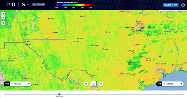
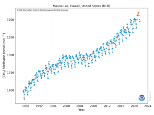
GHG/Methane Mapping
Target, Measure and Monitor Greenhouse Gases/Methane Emission from Space
Satellite Missions including:
Global/Region Mapping
TROPOMI ESA (http://www.tropomi.eu/)
SCIAMACHY (https://earth.esa.int/eogateway/instruments/sciamachy)
GOSAT (https://www.gosat.nies.go.jp/en/)
Area Mapping
MethaneSAT (https://www.methanesat.org/)
GEI-SAT (https://youtu.be/xaHwL40fIVg - https://satlantis.com/what-we-offer/)
Location Mapping
GHGSat (https://www.ghgsat.com/en/)
Carbon Mapper (https://carbonmapper.org/ - https://www.greenpolicy360.net/w/File:Carbon_Mapper_-_Launch_-_April_2021.jpg)
PRISMA (https://www.asi.it/en/earth-science/prisma/)
🌎
OCO-2 / OCO-3
- ············································
2021

- September 27, 2021


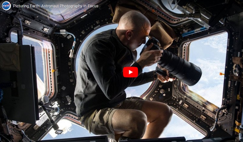
* https://earthobservatory.nasa.gov/features/videos/picturing-earth

······························································································································

What happens in the North doesn't stay in the North

- ·······························································································································

Satellite Monitoring of Methane from Space
Satellites Put the World’s Biggest Methane Emitters on the Map
Now the companies and countries responsible for a powerful greenhouse gas won’t be able to hide from view
Orange and yellow pixels flash over American drilling heartlands around the Gulf Coast, New Mexico, and Pennsylvania. Dark red stretches across Middle East and China, while disturbing dots of color pop up around Greenland’s coast. This is the dangerous world of atmospheric methane emissions, one of the most powerful drivers of global warning—and it’s visible to the public for the first time.
GHGSat Inc. released a new methane map on October 21, 2020 that uses data from the company’s two satellites, which were launched earlier this year and can detect methane emitted by oil and gas wells, coal mines, power plants, farms and factories. It’s part of a wave of climate surveillance that will make it possible to hold countries and companies accountable for meeting targets to reduce and eventually eliminate planet-warming pollution.
Global Emission Monitoring -- https://www.ghgsat.com/who-we-are/company/
https://assets.bwbx.io/images/users/iqjWHBFdfxIU/i1tYf3vLqrrU/v1/-999x-999.gif

································································································································
Detecting pollution of shipping lanes and individual ships from space
For the first time ever, scientists using data from @CopernicusEU #Sentinel5P were able to detect nitrogen dioxide plumes from individual ships from space.
A past study estimated that shipping emissions are globally responsible for around 400 000 premature deaths from lung cancer and cardiovascular disease, and 14 million childhood asthma cases each year.
For this reason, during the past decade, efforts to develop international shipping emission regulations have been underway. Since January 2020, the maximum sulphur dioxide content of ship fuels was globally reduced to 0.5% (down from 3.5%) in an effort to reduce air pollution and to protect health and the environment. It is expected that the nitrogen dioxide emissions from shipping will also become restricted during the coming years.
Monitoring ships to comply with these regulations is still an unresolved issue. The open ocean covers vast areas, with limited or no capacity to perform local checks. This is where satellites, such as the Copernicus Sentinel-5P satellite, come in...
Claus Zehner, ESA’s Sentinel-5P Mission Manager, commented, “We think that these new results demonstrate exciting possibilities for the monitoring of ship emissions in support of environmental regulation from space. Future planned satellite missions with improved spatial resolution, for example the Copernicus Anthropogenic Carbon Dioxide Monitoring satellites, should allow for the better characterisation of nitrogen dioxide ship emission plumes and, possibly, detection of smaller ship plumes.”
··························································································································

The ECOsystem Spaceborne Thermal Radiometer Experiment on Space Station (ECOSTRESS) will measure the temperature of plants and use that information to better understand how much water plants need and how they respond to stress.
ECOSTRESS will address three overarching science questions:
- How is the terrestrial biosphere responding to changes in water availability?
- How do changes in diurnal vegetation water stress impact the global carbon cycle?
- Can agricultural vulnerability be reduced through advanced monitoring of agricultural water consumptive use and improved drought estimation?
The ECOSTRESS mission will answer these questions by accurately measuring the temperature of plants. Plants regulate their temperature by releasing water through tiny pores on their leaves called stomata. If they have sufficient water they can maintain their temperature but if there is insufficient water their temperatures rise and this temperature rise can be measured with a sensor in space. ECOSTRESS will use a multispectral thermal infrared radiometer to measure the surface temperature. The radiometer that will be delivered to Houston for deployment on the International Space Station in 2018. The radiometer will acquire the most detailed temperature images of the surface ever acquired from space and will be able to measure the temperature of an individual farmers field.
·························································································

······································
From the International Space Station
Monitoring the Himalayan Glaciers Receding

···························································
Bringing Satellite Observations 'Down to Earth'
- Eos shows how scientists can sometimes get a better look at something by stepping far—much, much farther—away
- Earth Observations Inform Cities’ Operations and Planning
2020 Tracking Changes in the Arctic

2019 Arctic Report Card
The average annual land surface air temperature north of 60° N for October 2018-August 2019 was the second warmest since 1900. The warming air temperatures are driving changes in the Arctic environment that affect ecosystems and communities on a regional and global scale.
The Greenland Ice Sheet is losing nearly 267 billion metric tons of ice per year and contributing to global sea-level rise.
North American Arctic snow cover in May 2019 was the fifth lowest in 53 years of record. June snow cover was the third lowest.
Tundra greening continues to increase in the Arctic, particularly on the North Slope of Alaska, mainland Canada, and the Russian Far East.


September/August 2019
Monitoring the Climate Crisis
Monitoring the #ClimateCrisis... Interactive World Map
Mapped: How every part of the world has warmed and could continue to warm
···································································································
Satellites to Monitor Air Pollution across the World, City by City, Region by Region
(May 2019) Air pollution monitoring revolutionized with launch of new satellite system
• https://finance.yahoo.com/news/climate-crisis-satellites-monitor-air-155129758.html
“Emerging AI remote sensing techniques (intend) to hold every powerful polluter worldwide accountable ... better data ... puts most companies, governments, and environmentalists on the same side ... responsible, forward-thinking groups have started using advanced data to voluntarily slash emissions....”
Tracking damaging greenhouse gas emissions coming from every large power station in the world in real time
The system promises far greater accuracy and detailed emissions data for each power station, effectively reducing barriers to insight into the impacts of power generation, ensure accurate emissions data and bring new opportunities to hold companies to account.
The satellite network will observe the power plants from space, while AI technology will use the image processing algorithms to detect signs of power plant emissions.
- ··············································································
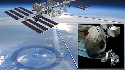
OCO-3 News Coverage Should Have Been of a Globally Important Event
OCO-3 arrives at the International Space Station to begin its earth science-space mission. There's little to find in Media coverage on its real-world importance whether on Google News, Bing Search, Yahoo, Duck Duck Go, pick your international news sources...
Yet, in fact and substance, the science of OCO-3 is critically important. Earth Science. Measuring CO2. JPL-Caltech/NASA, scientific inquiry at its best. Essential data and baseline information critical for informed policy and decision-making (yet President Donald Trump tried to kill the launch of OCO-3 and related US FY2018 missions to measure and monitor CO2).
A global security story... National security... Existential threats ...
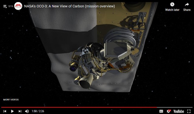
OCO-3 Arrives at the International Space Station
(Interview at JPL courtesy of the LA Times)
OCO-3 was built at the Jet Propulsion Laboratory for less than $100 million, using parts left over from its predecessor, OCO-2. Once the carbon observatory gets to the ISS, a robotic arm will mount it on the underside of the space station so it can keep a close eye on the carbon dioxide in Earth’s atmosphere.
That will help scientists answer questions about how and why levels of the greenhouse gas fluctuate over days, months and years.
“Our goal is to get really good data so we can make informed decisions about how to manage carbon and carbon emissions in the future,” said Annmarie Eldering, the mission’s project scientist at JPL.
Carbon dioxide makes up a tiny fraction of the molecules in our atmosphere — roughly 400 parts per million. But seemingly small changes in the amount of carbon dioxide in the atmosphere have an outsized effect on the planet’s temperature.
“Carbon is really effective at trapping heat,” Eldering said. “Even changing the ratio from 300 parts per million to 400 parts per million makes a big difference.”
OCO-3 is so sensitive that it can detect changes as small as 1 part per million. So if CO2 levels go from 406 ppm one day to 407 ppm the next, the space-based observatory will record the increase.
- ···················································································
- Detecting methane from space
- "There has been quite a buzz around this unique advancement in space, and the valuable data it will provide on methane, a powerful greenhouse gas that accounts for a quarter of the warming our planet is experiencing today. Curbing anthropogenic methane emissions is one of the most efficient and economical options available to slow the rate of warming over the next few decades, while efforts continue to reduce CO2 emissions worldwide."
- The Environmental Defense Fund (EDF) is planning to be the first environmental group to send its own satellite into space.
- “We need good solid data so that we really can support global action on climate change, and we’ve got to do it fast,” says Steven Hamburg, the EDF’s chief scientist.
- The most detailed measurements currently available of atmospheric methane concentrations currently come from a sensor aboard the European Space Agency’s Sentinel-5P spacecraft, which launched in October 2017. The Tropospheric Monitoring Instrument provides global coverage at a resolution of nearly 50 square kilometres, but those measurements do not capture the dispersed sources of emissions from oil and gas fields.
- Commercial firms have developed high-resolution sensors that can be placed aboard 10-centimetre-sided CubeSats to measure emissions from individual wells or other facilities. Those data are proprietary, however, and the measurements cannot be scaled up to the level of an entire oil and gas field.
- The Environmental Defense Fund team is designing MethaneSAT to provide more-precise measurements, at a resolution of 1 square kilometre, with global coverage at least once a week.
- ························································
New Maps, Antarctica’s Flowing Ice
https://eos.org/wp-content/uploads/2018/03/nasa-antarctica-ice-map-800x600.png
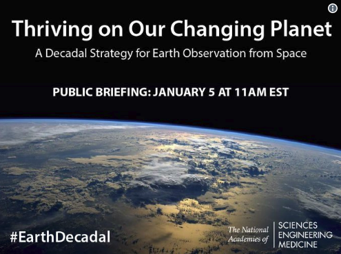
New Earth Science Decadel Survey Released
Thriving on Our Changing Planet (PDF)
First Full Disk Image from GOES-17 / Click for Whole Earth View

"Vital Signs": Monitoring the Earth's Life Enabling Systems
- Earth Research from Space Takes on the Challenge
Reefscape with Leonardo DiCaprio and Planet.com
- 'Measuring/Monitoring/Protecting the Health of Coral Reefs Globally

Measuring, Monitoring, Preserving & Protecting

···············································································
Looking Back as We Turn from 2017 to a New Year
"This year has been an unequivocal disaster for the future of the planet. President Donald Trump has managed to take a wrecking ball to years' worth of hard work and painstaking negotiations. If not undone, our retreat from the Paris Climate Accords and the EPA's Clean Power Plan alone mean our planet's temperature will rise at a greater rate and our citizen's health will degrade. Other changes in environmental regulations on drilling and auto and appliance efficiency will only make matters worse."
Perhaps the thing that worries me the most is the massive deforestation underway in areas like Asia and Latin America. Countless trees and millions of square miles of jungle and forest have been removed to accommodate our desires for more -- more wood, more farmland, more pasture, more meat.
When I first looked down upon the Amazon rainforest in 2001, I saw vast areas of jungle and a wide and winding copper colored river that went on and on and on. A river that was impossible to miss and like no other on the planet. By 2011, however, the part that was most noticeable wasn't the river or the jungle but the large swaths of empty land.
From space, it looks empty because we are far away. We don't see the crops or the cattle but we do see the loss. We see the loss of an incredibly diverse ecosystem that once held endless possibilities for new medicines and other discoveries.
We see the loss of a home for so many species that will now have to learn to adapt and survive somewhere else -- or not. And we see the loss of a large amount of carbon, sequestered in a living and breathing ecosystem which created massive amounts of oxygen for all of us.
That carbon, once the giver of life to millions of species all over our planet, now has a new role: greenhouse gas. It will sit in our atmosphere as CO and CO2 for millennia, but in this case as an invisible blanket, warming our planet, changing our climate and creating a cataclysmic mess for future generations.
-- By Mark Kelly / Updated 4:20 PM ET, Wed December 27, 2017
························································································

How Satellite Imagery Is Transforming Earth Science, Regional, National & Global Security
"Planetary Health": New methods, new analytical approaches to data collected from earth-facing observation platforms
“High-resolution earth imagery sources, beyond historic US/NASA/NOAA/ESA research from space, represent rich new troves of information...” says David Johnston of Duke University’s Nicholas School of the Environment. Johnson and his co-authors embrace satellite imagery “as a legitimate data source that can supplement and even supplant traditional methods.”
The rapidly growing abundance and sophistication of satellite imagery and remote sensing data is about to change (the scientific fields of earth science)... thanks to a profusion of startup companies, including Planet, DigitalGlobe, Skybox Imaging (later purchased by Google and renamed Terra Bella), Urthecast, and LAND INFO Worldwide Mapping.
NASA is also part of this trend. In 2019, NASA plans to launch a mission called GEDI (the Global Ecosystem Dynamics Investigation) using lidar, a laser-based remote sensing technology...
From the International Space Station, GEDI will enable scientists to determine the height and structure of forests in any given location and precisely map above ground biomass and carbon storage...
NASA Challenges the Public to Join In
GreenPolicy360 / Virtual Earth Mapping
The technology will prove useful for monitoring commitments made by nations under REDD (the program to reduce emissions from deforestation and forest degradation) as well as under the Paris climate accord and the Convention on Biological Diversity...
• https://www.greenpolicy360.net/w/Category:INDC
• https://www.greenpolicy360.net/w/Category:Environmental_Security
Measuring Changes in Earth's Ecosystems Over Time
"Data Sets / Shifting Baselines"

························································
Threats to National and Global Security
US Retreats from Global Stage, Moves Backwards Under Current White House
The 'Trump Doctrine', a Legacy in the Making
Time to Act as the US President says No to the Global Community and No to the International Climate Agreement

Better Climate Observation Needed
Former NOAA Chief Scientist Warns of Threats to Science
Scientists Fear Climate Data Gap as Trump Aims at Satellites
18 NASA Earth Science Missions in Space

2017 / Updates
Via Scientific American
Ageing Satellites Put Crucial Sea Ice Climate Record at Risk
Track Earth Science Missions, the Politics of Earth Science from Space, and Global/National Security
US Politics and Earth Science Research from Space
Trump Administration Budget Undercuts "Earth Science" at NASA
- Vital Security Programs Cut / OCO-3 Mission to Study CO2 in Atmosphere Eliminated
The proposed NASA budget targets the agency’s work on environmental science, cutting funding for Earth science research grants. The cuts would go further by eliminating several missions that are in development, including PACE (Plankton, Aerosol, Cloud, ocean Ecosystem), which is intended to monitor and provide baseline data of the Earth’s ocean and their health; the Orbiting Carbon Observatory 3, or OCO-3, an instrument to precisely monitor the carbon dioxide in our atmosphere, continuing the unique work of OCO-2; and the Climate Absolute Radiance and Refractivity Observatory, or CLARREO, pathfinder, which is to use a solar spectrometer to produce highly accurate climate projections.
Protecting "The Commons", the "Thin Blue Layer", the Global Atmosphere
Look at how thin our atmosphere is...
Baseline Data and the Damage of Interruptions in Baseline Data
○ ○ ○ ○ ○ ○ ○ ○ ○ ○ ○ ○ ○ ○
Planet Citizens
- Time for Planet Citizen Action 🌎
A Call to Action to Preserve & Protect Life on Earth
- It's Your Time and, as GreenPolicy360 speaks of 'Becoming Planet Citizens'
New Definitions of National Security
"New Definitions of National Security"
- A Project of GreenPolicy360 and Strategic Demands

○ ○ ○ ○ ○ ○ ○ ○ ○ ○ ○ ○ ○ ○ ○ ○ ○ ○
Space 'Macroscope', Earth Science
Yale Environment 360 / by Richard Conniff / June 2017
Google, Earth Observations, Earth Science
Mapping the Earth in the 21st Century
○ ○ ○ ○ ○ ○ ○ ○ ○ ○ ○ ○ ○ ○ ○ ○ ○ ○ ○ ○ ○ ○
*The Critical Importance of "EarthScience360" from Space
GreenPolicy360: The election of Donald Trump as US president delivers immediate crisis and a turning point. The president-elect's statements that climate change is a 'hoax' and environmental policies and programs, including NASA 'Earth Sciences', are impediments that need to be ended now assures tumult and a new level of threat to national and global security. Announced administration appointees, as of November 2016, and recent Congressional threats to deeply cut environmental protection and NASA 'Earth Science' budgets are warning signs of coming showdowns over the direction of the nation and the nation's priorities.
NASA scientists responsible for vital programs have been reluctant to speak publicly since the election but one anonymous NASA scientist is among the first to write online about the value of earth science research from space.
Anon: "We are the largest combined organization of scientists and engineers in the world dedicated to space-based observations of Earth, the Solar System, and the Universe. A huge part of our mission is to design and fabricate Earth-viewing satellites that track long-term changes in topography and climate. These satellites ensure that we have the most complete set of data available to not only predict how humanity's impacts will affect the Earth, but also understand how we can prepare and protect those most vulnerable to climate change and rising sea levels. As an example of our impact on the daily lives of people around the world, one of the satellites I previously worked on, Global Precipitation Measurement, is currently in Earth orbit tracking extreme weather events. Its data allows meteorologists to improve their forecasts of where hurricanes will strike and how intense they will be, as well as to identify the areas that are most prone to floods and landslides, so that we can give advanced warnings to those affected. This is just one of dozens of major Earth-observing satellites that NASA manages everyday.
"Today, we were shocked to hear of Trump's plan to scrap NASA's climate change research as part of a crack down on "politicized science". Among the scientific community, climate change is no more "politicized science" than the theory of gravity is. While his crackdown would mean that thousands of scientists and engineers at NASA Goddard would lose their livelihoods, it represents an even greater loss for the world. Without data continuity in our Earth observations, we will be blind to the ravages of climate change: to the deluges and droughts that might devastate crops, to the extreme weather events that destroy communities as the Earth continues to warm. We will not be able to develop the solutions that can prevent Earth's temperatures from rising to catastrophic levels. I urge you to implore your Congressional Representatives to not allow Trump's plan to happen. We cannot sit on the sidelines over the next four years: our future on this planet is at stake."
Follow the Action (of anti-science forces) as the US Congress Looks to Block Earth Science

Under Trump, Will NASA’s Space Science Include Planet Earth?
- -- By Andrew C. Revkin / November 28, 2016 / Dot Earth

December 14, 2016
Speaking directly to threats to the value of earth science and earth science research from space, Governor Brown addressed the American Geophysical Union (AGU) Fall Meeting in California. The AGU annual gathering is the largest Earth and space science meeting in the world.
The AGU is an international scientific society that describes itself as "dedicated to promoting discovery in Earth and space science for the benefit of humanity."
Jerry Brown:
"We got the scientists. We got the lawyers. And we're ready to fight. We're ready to defend. And California is no stranger to this fight...
"California is the future. We are pioneering space...
"Now some people say they're going to turn off the satellites that are monitoring the climate... low-earth phenomena, the LANDSAT and all the various measuring satellites that we have...
"Well, I remember back in 1978 I proposed a LANDSAT satellite for California. They called me 'Governor Moonbeam' because of that. I didn't get that moniker for nothing.
"And if Trump turns off the satellites, California will launch its own (d-mn) satellites!"
○ ○ ○ ○ ○ ○ ○ ○ ○ ○ ○ ○ ○ ○ ○ ○ ○ ○
More Satellites Launched to Monitor Planet Change
- NASA Earth Science Missions - https://eospso.gsfc.nasa.gov/current-missions

- ○ ○ ○ ○ ○ ○ ○ ○ ○ ○ ○ ○ ○
Earth Science, Ocean Science
- Studying Sea-Level Rise from Space
- Jason-3 Successfully Launched into Orbit --- Follow Jason Online
Drought, heat, water loss, aquifers depleted
- Satellite missions tracking climate change/global warming impacts


I am OCO-2 -- 'Reporting Home'
Visit the Orbiting Carbon Observatory
Climate deniers blame global warming on nature. NASA data begs to differ

Visit NASA's Earth Science News
"Vital Signs of the Planet"
Critical Missions to Monitor Earth's Systems from Space -- http://climate.nasa.gov/
- https://www.greenpolicy360.net/w/Climate_News | Climate News
- https://www.greenpolicy360.net/w/Category:Earth_Observations | Earth Observations
- https://www.greenpolicy360.net/w/Category:Environmental_Security | Environmental Security
- Democratization of Space | https://www.greenpolicy360.net/w/Democratization_of_Space
- Earth Imaging-New Space | https://www.greenpolicy360.net/w/Earth_Imaging-New_Space
- Earth Right Now | https://www.greenpolicy360.net/w/Earth_Right_Now
Earth Science Research from Space
Back to the first Earth Imaging & Earth Science Missions from Space
Landsat and (now) Decades of Digital 'Multispectral' Data | https://www.greenpolicy360.net/w/Landsat_data_users_handbook
Today, the 'New Space' Micro-satellites | https://www.greenpolicy360.net/w/Micro-satellites
- New Space | https://www.greenpolicy360.net/w/New_Space
- Planet Labs Doves Fly | https://www.greenpolicy360.net/w/Planet_Labs_Doves_Fly
- Thin Blue Layer | http://www.thinbluelayer.com
- Earth Observations - https://www.greenpolicy360.net/w/Category:Earth_Observations
- Earth Science - https://www.greenpolicy360.net/w/Category:Earth_Science
- Climate Change - https://www.greenpolicy360.net/w/Category:Climate_Change
- Global Security - https://www.greenpolicy360.net/w/Category:Global_Security
GreenPolicy360 Siterunner: In the late 1960s and early 70s, Congressman George Brown on the Space and Technology Committee was pressing forward with NASA's development of the first array of earth science satellite missions. Near the top of his list of project missions was LANDSAT 1.
Representative Brown was out in front of "Big Science". In his decades on the House Science, Space & Technology Committee, he worked to expand the reach of science. He knew that good data enabled good policy decisions. He pressed for first-generation earth science satellites and ongoing earth monitoring missions and data sharing.
Among his many initiatives, George Brown was a key figure in proposing, establishing, and then saving the Landsat program and its unique 'open-access' database of Earth Science imaging when President Reagan attempted to shut Landsat down. Landsat was a model for all the following earth science research missions from space and is now moving into its fifth decade with Landsat 9.


|
|
- ○
NASA/NOAA Earth Observing Satellite Updates
How satellites are used to monitor climate change
Satellites in operation (2016) that are adding to scientists’ understanding of climate change
https://www.carbonbrief.org/interactive-satellites-used-monitor-climate-change

○ ○ ○ ○ ○ ○ ○ ○ ○ ○ ○ ○ ○ ○ ○ ○
Jason-3 Mission -- Jason-3 -- Launched Jan 17, 2016
Ocean circulation patterns, global and regional changes in sea level, and climate implications of a warming world
○ ○ ○ ○ ○ ○ ○ ○ ○ ○ ○ ○ ○ ○ ○ ○
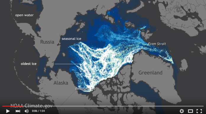
"Watch 25 years of Arctic Sea Ice disappear"
○ ○ ○ ○ ○ ○ ○ ○ ○ ○
https://www.pinterest.com/stratdem/
https://strategicdemands.com/another-view-of-thin-blue/

○ ○ ○ ○ ○ ○ ○ ○ ○ ○ ○ ○ ○ ○ ○ ○ ○ ○
https://www.greenpolicy360.net/w/New_Definitions_of_National_Security
https://www.greenpolicy360.net/w/Category:Environmental_Security
○
Latest from the Atmospheric Science Data Center (ASDC) at NASA Langley Research Center
NASA Earth science data in the areas of radiation budget, clouds, aerosols, and tropospheric chemistry
https://eosweb.larc.nasa.gov/ --- https://eosweb.larc.nasa.gov/projects-supported
April 2015
A Successful Era in Climate Science
Calipso - Ten Years in Space (and Flying with the 'A-Train')
Since its launch in 2006, CALIPSO has orbited the Earth tirelessly, using its lasers to take more than 5.7 billion lidar (light detection and ranging) measurements probing the vertical structure and properties of clouds and other particles — such as dust, sea salt, ash and soot — in the air.
For atmospheric scientists, the ability to regularly and accurately examine clouds and particles at different heights was something new. Gathering that data over such a long time period has contributed to a scientific bonanza.
Also, scientists are able to combine CALIPSO’s measurements with those of other Earth-observing satellites circling the globe in a cooperative path called the A-Train constellation. CALIPSO and CloudSat, a satellite containing a cloud-profiling radar, launched together on a Delta II rocket, now fly in formation with satellites named Aqua, Aura, Global Change Observation Mission-Water (GCOM-W) and Orbiting Carbon Observatory (OCO)-2.
Combining measurements from these A-Train satellites offers a clearer view of what’s happening in the atmosphere.
“CALIPSO, in complement with the other instruments flying in the A-Train, has provided observations in areas that had never been observed before,” said Pierre Tabary, program manager for atmosphere, meteorology and climate for CNES, the French space agency.
He said scientists have gained knowledge about clouds, and their impact on incoming solar radiation, as well as on infrared radiation coming from the Earth’s surface, known as the greenhouse effect.
“There were no other instruments providing such observations before,” Tabary said. “All those data have been used to improve our understanding of how climate works.”
More than 1,600 scientific and technical reports and published research papers have used CALIPSO data. The data are widely cited in reports from the Intergovernmental Panel on Climate Change", Tabary said, "a clear demonstration of what CALIPSO has brought to climate science."
Read More about the 'A-Train'
A convoy of "A-Train" satellites has emerged as one of the most powerful tools scientists have for understanding our planet's changing climate...
○
March 2015
One of the many critical NASA earth science missions from space reports:
○

- DSCOVR is launched and on its way!
Godspeed DSCOVR... On February 12, 2015 the DSCOVR satellite with its EPIC cam and earth-science instrument package is on the way...
A million mile journey to its orbit, DSCOVR is scheduled to light up, go through its testing phases and begin delivering data to Earth in August, including near-real-time imaging of Earth provided online ...
We/GreenPolicy360 are cooperating with NASA DSCOVR mission managers and will be delivering a stream of home planet imagery and data as NASA/NOAA begin uploading EPIC-cam and instrument 'pictures of home'!
For GreenPolicy360, the centerpiece of the mission will be the EPIC cam images of Earth 360
First whole earth pictures to be delivered from deep space since 1972 -- images we are looking to share as a life message of our home planet.
Planet Citizens, Planet Scientists
○
It's been some time since December 7, 1972 when the only picture ever snapped by a human of the whole earth was captured -- our iconic "Blue Marble" -- Engineers that they are, NASA named that first planet citizen/astronaut-taken image -- AS17-148-22727
As we have been recalling the history, we haven't had returned to us a 'whole earth' image since 1972. Today, February 10, 2015, the Associated Press reports Sen. Bill Nelson, D-Florida, pointing out from Washington that there hasn't been a full, sunlit picture of the Earth since Apollo 17 in 1972 - NASA's last manned moon-landing mission. Subsequent images have been stitched together, the Senator explained, for composite shots. The Senator has an exceptional point of view as he was an astronaut -- In January 1986, Nelson spent six days orbiting Earth as a payload specialist aboard space shuttle Columbia. His NASA bio adds "The experience gave him a new perspective on the Earth’s fragile environment and a greater appreciation of the importance of our nation’s space exploration program."
The DSCOVR satellite launches into deep orbit with multiple missions -- to monitor space weather and, due to the satellite's orbital distance from Earth (1 mil miles), DSCOVR will be sending back daily images of the 'whole earth' via its EPIC image-taking system and via its NISTAR system measuring earth's earth's temperature, our "radiation balance" ("albedo").
○ ○ ○ ○
- ISS mission to monitor #planethome
[[
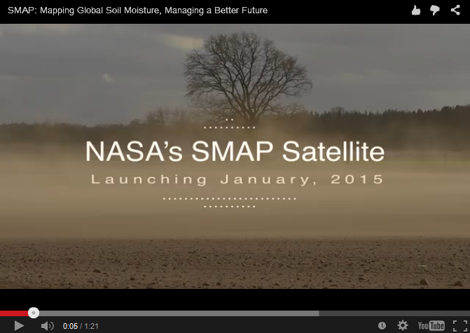
- Time to measure earth soil moisture content -- SMAP
January 2015
Launching Jan 29, 2015 to "measure the moisture in Earth's soils with unprecedented accuracy and resolution.
○ ○ ○ ○
- Existential -- Monitoring "vital signs", scientific observations over time, a baseline of planet Earth
NASA OCO Satellite Sends Back Most Detailed CO2 View Ever
Initial round of CO2 data is released...
First full set of CO2 data made available in March 2015 for scientists and public to download and explore.
More on the history-making OCO-2 / Orbiting Carbon Observatory
According to JPL scientists: "Where OCO-2 really excels is the sheer amount of data being collected within a day, about one million measurements across a narrow swath... For fluorescence, this enables us, for the first time, to look at features on the five- to 10-kilometer scale on a daily basis." SIF can be measured even through moderately thick clouds, so it will be especially useful in understanding regions like the Amazon where cloud cover thwarts most spaceborne observations."
The changes in atmospheric carbon dioxide that OCO-2 seeks to measure are so small that the mission must take unusual precautions to ensure the instrument is free of errors. For that reason, the spacecraft was designed so that it can make an extra maneuver. In addition to gathering a straight line of data like a lawnmower swath, the instrument can point at a single target on the ground for a total of seven minutes as it passes overhead. That requires the spacecraft to turn sideways and make a half cartwheel to keep the target in its sights.
The targets OCO-2 uses are stations in the Total Carbon Column Observing Network (TCCON), a collaborative effort of multiple international institutions. TCCON has been collecting carbon dioxide data for about five years, and its measurements are fully calibrated and extremely accurate. At the same time that OCO-2 targets a TCCON site, a ground-based instrument at the site makes the same measurement. The extent to which the two measurements agree indicates how well calibrated the OCO-2 sensors are.
Additional maps released recently showed the results of these targeting maneuvers over two TCCON sites in California and one in Australia. "Early results are very promising," said Paul Wennberg, a professor at Caltech and head of the TCCON network. "Over the next few months, the team will refine the OCO-2 data, and we anticipate that these comparisons will continue to improve."
More about the OCO-2 mission, making history as it reveals the extent of atmospheric CO2
○ ○ ○ ○
- Tracking ocean currents, 'best-ever data
November 2014
Scientists produce "the most accurate space view yet of global ocean currents and the speed they move..."
- ○ ○ ○ ○ ○ ○ ○ ○ ○ ○ ○ ○ ○ ○ ○ ○ ○ ○ ○ ○ ○ ○

Geo-Facts to Keep in Mind
As of 2021, about ten percent of the world's population, some 770 million people, live on land less than 5 meters above the high tide line.
Sea-Level change over time... Satellites began measuring sea level precisely in 1993.
Globally, 410 million people at risk from sea level rise
"It's All Connected": Small to Large"
- The Oceans, ~70% of the Earth's Surface

Ocean Food Chain -- Ocean Ecosystems / #OceanScience
Phytoplankton... Diatoms... Oxygen Creators, CO2 Digesters... Zooplankton, Food-of-the-Seas


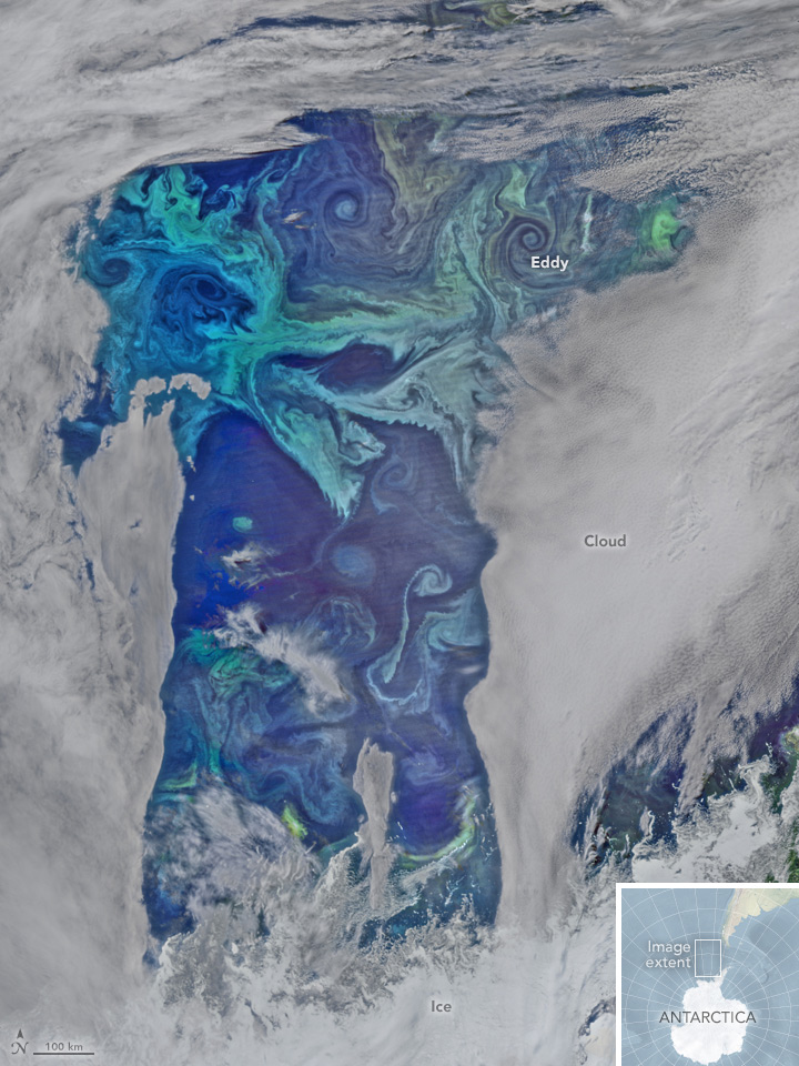
Plankton Swirl -- Climate Dance

Phytoplankton Oxygen Factories in the Southern Ocean
NASA Earth Observatory
Phytoplankton are essential ecosystems of the seas. They are floating, drifting, plant-like organisms that harness the energy of the Sun, mix it with carbon dioxide that they take up from the atmosphere, and turn it into carbohydrates and oxygen.
Scientific estimates speak of approximately half the oxygen in the Earth's atmosphere being the result of plankton photosynthesis and phytoplankton are critical to the marine food web, being the primary producers of food in the oceans, from phytoplankton to zooplankton to fish and shellfish to whales.
Like plants and trees on land, "phytoplankton give us a lot more than food". Whether the current science estimates that 50 or 80 percent of the oxygen in our atmosphere has been produced by phytoplankton, the health of the blue-green ocean life is essential for sustainable ocean ecosystems. The tiniest of living organisms exert an outsized influence on the planet.
https://eoimages.gsfc.nasa.gov/images/imagerecords/87000/87465/sepacific_vir_2016013.jpg
○ ○ ○ ○ ○ ○ ○ ○ ○ ○ ○ ○ ○ ○ ○ ○ ○ ○ ○ ○ ○ ○ ○ ○ ○
Phytoplankton rapidly disappearing
Loss of mini marine plants at base of food web threatens sea’s ecology
A rapid loss of phytoplankton threatens to turn the western Indian Ocean into an “ecological desert,” a new study warns. The research reveals that phytoplankton populations in the region fell an alarming 30 percent over the last 16 years.
A decline in ocean mixing due to warming surface waters is to blame for that phytoplankton plummet, researchers propose online January 19 in Geophysical Research Letters. The mixing of the ocean’s layers ferries phytoplankton nutrients from the ocean’s dark depths up into the sunlit layers that the mini plants inhabit.
The loss of these microbes, which form the foundation of the ocean food web, may undermine the region’s ecosystem, warns study coauthor Raghu Murtugudde, an oceanographer at the University of Maryland in College Park.
“If you reduce the bottom of the food chain, it’s going to cascade...”
Blue-Green in the Oceans & Connection to Life on Earth
- "A single kind of blue-green algae in the ocean produces the oxygen in one of every five breaths we take"
- ~ from "The World Is Blue: How Our Fate and the Ocean’s Are One" by Sylvia Earle / National Geographic
○ ○ ○ ○ ○ ○ ○ ○ ○ ○ ○ ○
New NASA ERA
Sept 08, 2014 - NASA opens another era in its exploration of our home planet with the launch of the first in a series of Earth science instruments to the International Space Station, Earth-observing instruments to be mounted on the exterior of the #ISS. ISS-RapidScat will monitor ocean winds for climate research, weather predictions and hurricane monitoring. The second instrument is the Cloud-Aerosol Transport System (CATS), a laser instrument that will measure clouds and the location and distribution of pollution, dust, smoke, and other particulates in the atmosphere. Look closer at the array of instruments #RapidScat #EarthRightNow
○ ○ ○ ○ ○ ○ ○ ○ ○ ○ ○ ○ ○ ○ ○ ○ ○ ○ ○ ○ ○ ○
Ice impacts of Climate Change -- Arctic/Antarctic
The Antarctic: Big Melt Accelerates

The Antarctic: Big Melt Accelerates - Cryosat - Greenland
Antarctica's Flowing Ice - Antarctica
○
The Arctic Ice Is Melting: Why?
Permafrost Loss, Potential Impacts, Time to Measure
Scientists estimate that five times as much carbon might be stored in frozen Arctic soils — permafrost — as has been emitted by all human activities since 1850. This worries people who study global warming. While emissions from permafrost currently account for less than 1 percent of global methane emissions, some researchers think this could change in dramatic ways as the world warms and that carbon-rich frozen soil breaks down.

The map above, based on data provided by the National Snow and Ice Data Center, shows the extent of Arctic permafrost. Any rock or soil remaining at or below 0 degrees Celsius (32 degrees Fahrenheit) for two or more years is considered permafrost.
Continuous permafrost, which occurs in the coldest areas, refers to areas where frozen soil underlies more than 90 percent of the surface. Discontinuous permafrost occurs in slightly warmer areas, where frozen soils underlie 50 to 90 percent of the surface, while certain features such as rivers and south-facing slopes may be ice-free. In areas with sporadic permafrost, frozen soils underlie 10 to 50 percent of the surface. In areas with isolated permafrost, frozen soils underlie less than 10 percent of the surface, usually only occurring in depressions or north-facing slopes.
○ ○ ○ ○ ○ ○ ○ ○ ○ ○ ○ ○ ○ ○ ○ ○ ○
November 2015
As Earth Warms, NASA Targets 'Other Half' of Carbon, Climate Equation

Permafrost Threatened
Using statistically modeled maps drawn from satellite data and other sources, U.S. Geological Survey scientists have projected that the near-surface permafrost that presently underlies 38 percent of boreal and arctic Alaska would be reduced by 16 to 24 percent by the end of the 21st century under widely accepted climate scenarios. Permafrost declines are more likely in central Alaska than northern Alaska.
Northern latitude tundra and boreal forests are experiencing an accelerated warming trend that is greater than in other parts of the world. This warming trend degrades permafrost, defined as ground that stays below freezing for at least two consecutive years. Some of the adverse impacts of melting permafrost are changing pathways of ground and surface water, interruptions of regional transportation, and the release to the atmosphere of previously stored carbon.
“A warming climate is affecting the Arctic in the most complex ways,” said Virginia Burkett, USGS Associate Director for Climate and Land Use Change. “Understanding the current distribution of permafrost and estimating where it is likely to disappear are key factors in predicting the future responses of northern ecosystems to climate change.”
○ ○ ○ ○ ○ ○ ○ ○ ○ ○ ○ ○ ○ ○
A severe threat to tundra is global warming, which causes permafrost to melt. The melting of the permafrost in a given area on human time scales (decades or centuries) could radically change which species can survive there.
Another concern is that about one third of the world's soil-bound carbon is in taiga and tundra areas. When the permafrost melts, it releases carbon in the form of carbon dioxide and methane, both of which are greenhouse gases. The effect has been observed in Alaska. In the 1970s the tundra was a carbon sink, but today, it is a carbon source. Methane is produced when vegetation decays in lakes and wetlands.
The amount of greenhouse gases which will be released under projected scenarios for global warming have not been reliably quantified by scientific studies, although a few studies were reported to be underway in 2011. It is uncertain whether the impact of increased greenhouse gases from this source will be minimal or massive.
* https://en.wikipedia.org/wiki/Tundra
* https://en.wikipedia.org/wiki/Methanogenesis -- https://en.wikipedia.org/wiki/Greenhouse_gas
○ ○ ○ ○ ○ ○ ○ ○ ○ ○ ○ ○ ○ ○ ○
What Happens in the North, Doesn't Stay in the North
A self-reinforcing positive feedback loop is akin to a "vicious circle": It accelerates the impacts of anthropogenic climate disruption (ACD). An example would be methane releases in the Arctic. Massive amounts of methane are currently locked in the permafrost, which is now melting rapidly. As the permafrost melts, methane - a greenhouse gas 100 times more potent than carbon dioxide on a short timescale - is released into the atmosphere, warming it further, which in turn causes more permafrost to melt, and so on...
○ ○ ○ ○ ○ ○ ○ ○ ○ ○ ○ ○ ○ ○ ○ ○
Predicted rate of temperature change in Arctic
Arctic temperatures are expected to increase at roughly twice the global rate. The Intergovernmental Panel on Climate Change (IPCC) will in their fifth report establish scenarios for the future, where the temperature in the Arctic will rise between 1.5 and 2.5°C by 2040 and with 2 to 7.5°C by 2100. Estimates vary on how many tons of greenhouse gases are emitted from thawed permafrost soils. One estimate suggests that 110-231 billion tons of CO2 equivalents (about half from carbon dioxide and the other half from methane) will be emitted by 2040, and 850-1400 billion tons by 2100. This corresponds to an average annual emission rate of 4-8 billion tons of CO2 equivalents in the period 2011-2040 and annually 10-16 billion tons of CO2 equivalents in the period 2011-2100 as a result of thawing permafrost. For comparison, the anthropogenic emission of all greenhouse gases in 2010 is approximately 48 billion tons of CO2 equivalents. Release of greenhouse gases from thawed permafrost to the atmosphere may increase global warming.
Via Berkeley Lab -- A Simpler Way to Estimate the Feedback Between Permafrost Carbon and Climate
Simplified, data-constrained approach to estimate the permafrost carbon–climate feedback
Via University of Cambridge -- Analysis of the effects of melting permafrost in the Arctic points to $43 trillion in extra economic damage by the end of the next century, on top of the more than the $300 trillion economic damage already predicted

Alaska's Stirring Permafrost
Landsat data continues, as GreenPolicy360 recalls the beginnings of the Earth Science research from space, those who envisioned the NASA missions as a way of 'protecting the home planet'
The Melting North: As the Arctic Ice Retreats
○
Targeting Methane
This 2012 program augers a future of earth science research from space that is used for oil/gas 'clean-up' and environmental protection
'You have to measure to manage' and the measurement of methane, its locality, its 'provenance' is a step forward
··································
Watching the Ice Melt
New assessments of impacts of global warming via Europe's Cryosat spacecraft
The CryoSat is part of the Living Planet Programme
- https://en.wikipedia.org/wiki/Living_Planet_Programme]
- https://www.esa.int/Our_Activities/Observing_the_Earth/The_Living_Planet_Programme
- https://en.wikipedia.org/wiki/European_Space_Agency ESA]
Cooperative earth monitoring science between US-Europe ...
More data re ice melt-GRACE/US-NASA / [1] GRACE
··································································
The European Space Agency's(ESA) Mission:
To benefit citizens "asking for a better quality of life on earth... for greater security and economic wealth... to pursue dreams, to increase knowledge... for younger people to be attracted to the pursuit of science and technology... ESA's purpose shall be to provide for, and to promote, for exclusively peaceful purposes, cooperation in space research and technology and space applications, with a view to their being used for scientific purposes..."
ESA Earth Observing System satellites -- ESA Earth monitoring from Space
Earth-observing satellites for earth system monitoring include:
The European Space Agency (ESA) "Living Planet Programme" managed by Earth Observation Programmes - [2]
- GOCE – Gravity Field and Steady-State Ocean Circulation Explorer - launched on March 17, 2009 - [3]
- SMOS – Soil Moisture and Ocean Salinity satellite - studying ocean salinity and soil moisture; launched in 2 November 2009 - [4]
- CryoSat is designed to map the Earth's ice cover. CryoSat-1 was lost in 2005. CryoSat-2 was launched 8 April 2010 - [5]
- Swarm – is a trio of satellites to map the Earth's magnetism. The SWARM constellation was launched successfully on 22 November 2013 - [6]
- Aeolus – Atmospheric Dynamics Mission will use an innovative laser to measure winds. Due for launch in 2015 - [7]
- EarthCARE – Earth Clouds Aerosols and Radiation Explorer will examine the formation and effects of clouds. Due for launch in 2016 - [8]
- BIOMASS is designed to calculate the amount of carbon stored in the world's forests, and to monitor for any changes over the course of its five-year mission. Due to launch in 2020 - [9]

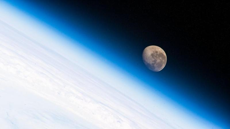

- About Us
- Aquifers
- Arctic
- Atmosphere
- Biodiversity
- Climate Change
- Climate Policy
- Digital Citizen
- Earth360
- Earth Imaging
- Earth Law
- Earth Observations
- Earth Science
- Earth Science from Space
- Earth System Science
- Eco-nomics
- Eco-ethics
- Eco-Spirituality
- Ecology Studies
- Ecoregions
- Education
- Environmental Full-cost Accounting
- Environmental Security
- Environmental Security, National Security
- EOS eco Operating System
- ESA
- Externalities
- Fisheries
- Forests
- Food-Related Policies
- Global Security
- Global Warming
- ISS
- Land Ethic
- Land Use
- Maps
- NASA
- Natural Resources
- New Definitions of National Security
- New Space
- NOAA
- Oceans
- Ocean Ecosystem
- Ocean Science
- Ocean Sustainability
- Planet API
- Planet Citizen
- Planet Citizens
- Planet Scientist
- Planet Citizens, Planet Scientists
- PlanetLabs
- Sea-Level Rise & Mitigation
- Soil
- Solar Energy
- Strategic Demands
- Sustainability
- Sustainability Policies
- ThinBlueLayer
- Threat Multiplier
- US Environmental Protection Agency
- Water
- Whole Earth
- World Wide Web
- Atmospheric Science
- Biogeosciences
- Cryosphere
- Geophysics and Geochemistry
- Mineralogy
- Geology
- Geophysics
- Hydrology
- Planetary Science
- Space Science and Space Physics