Landsat data users handbook


First, a Map of the Entire U.S.—and Then the World
The USGS Earth Resources Observation and Science (EROS) Center, celebrating its 50th anniversary this year, was developed at the beginning of the Landsat Earth observation satellite program as a place to store and distribute the imagery. Through the years, EROS has become much more—including a place to advance land cover mapping and monitoring through an unbiased scientific lens...
In the 1980s, as EROS began its International Program, a different type of satellite data factored in. TheAdvanced Very High Resolution Radiometer (AVHRR) sensor aboard National Oceanic and Atmospheric Administration (NOAA) meteorological satellites could cover the entire Earth in one day at a coarse scale and reveal information about vegetation cover and conditions.
Examples of applications of the global database included the World Resource Institute Global Watersheds Vulnerability Assessment, the United Nations Food and Agriculture Organization Global Forest Resources Assessment and the National Geographic Society Satellite Atlas of the World.

NASA Earth
Over Five Decades of Unique Earth Science Imaging from Space
- A Profoundly Vital Resource of Digital Data Mapping Earth's Systems
- Beginning with the Work of 'the MSS', the Multispectral Scanning System

- 'Multispectral', Digital and Dynamic -- https://landsat.gsfc.nasa.gov/
🌎
Planet Citizens, Landsat Visionaries - George E. Brown & Virginia Tower Norwood
🌎

50th + Anniversary of Landsat

http://www.greenpolicy360.net/mw/images/Landsat8DataUsersHandbook.pdf
Envisioned as an Intergenerational Science Mission
The first land-focused Earth-observation satellite, Landsat 1 (initially called the 'Earth Resources Technology Satellite-1 / ERTS-1) is launched to Earth orbit from Vandenberg, CA.
Beginnings of Earth Science from Space #RemoteSensing #AtmosphericScience #EarthScience #OceanScience


The Landsat Vision and Mission Continues with the Launch of Landsat 9


9 Things About Landsat 9 !!!!!!!!!
- NASA (2021)
New Landsat Mission Launches Successfully
Interior Department Secretary Deb Haaland says the program provides "a rich form of data" that helps people in their everyday lives and is vital in dealing with climate change.
The U.S. Interior Department, the U.S. Geological Survey, NASA with the Congressional Science and Technology Committee (originally the Science and Astronautics Committee were responsible for building the original Landsat program (which overcame much opposition within the military). ERTS-1, the Earth Resources Technology Satellite, as the original Landsat satellite was officially first called, was 'greenlighted' to go as a real time earth observation mission in 1970. The vast digital database it gathered has proven over the years the wisdom of the visionaries who first proposed, drafted legislation creating, funding, then engineering, testing, launching and ably defending the Landsat mission from critics over the decades. Now the results are being re-considered for the unique value they provide in guiding policy discussion, debate and decisions. The Landsat library of imagery, millions of images, multispectrum observations of change on earth over the first fifty years of the mission's existence, are seen in a new light.
"We're in the thick of the climate crisis right now, we see that every day — drought, wildfires, hurricanes, Hurricane Ida that devastated parts of the South and went all the way up to New England," the current Interior Department head, Ms Haaland, the first Native American to hold the post said.
"Images like the ones that Landsat 9 will bring back to us will help to guide us in how we are approaching climate change, working to make sure that we can make the best decisions possible, so that folks have water into the future, that we can grow our food into the future."
🌎
2020 / Another anniversary / Social media takes a look -- https://www.facebook.com/nasaearth/videos/287188646049566/
The Landsat Program has provided decades of calibrated high spatial resolution data of the Earth's surface to a broad and varied user community, including agribusiness, global change researchers, academia, state and local governments, commercial users, national security agencies, the international community, decision makers, and the general public. Landsat images provide information meeting the broad and diverse needs of business, science, education, government, and national security.
The mission of the Landsat Program is to provide repetitive acquisition of moderate-resolution multispectral data of the Earth's surface on a global basis. Landsat represents the only source of global, calibrated, moderate spatial resolution measurements of the Earth's surface that are preserved in a national archive and freely available to the public. The data from the Landsat spacecraft constitute the longest record of the Earth's continental surfaces as seen from space. It is a record unmatched in quality, detail, coverage, and value.
The Landsat 8 observatory offers these features:
Data Continuity: Landsat 8 is the latest in a continuous series of land remote sensing satellites that began in 1972.
Global Survey Mission: Landsat 8 data systematically builds and periodically refreshes a global archive of sun-lit, substantially cloud-free images of the Earth's landmass.
Free Standard Data Products: Landsat 8 data products are available through the USGS EROS Center at no charge.
- See #IC, International Collaborators -- http://landsat.usgs.gov/BenefitsofBecominganIC.php
Radiometric and Geometric Calibration: Data from the two sensors, the Operational Land Imager (OLI) and the Thermal Infrared Sensor (TIRS), are calibrated to better than 5% uncertainty in terms of top-of-atmosphere reflectance or absolute spectral radiance, and having an absolute geodetic accuracy better than 65 meters circular error at 90% confidence (CE 90).
Responsive Delivery: Automated request processing systems provide products electronically within 48 hours of order (nominally much faster).
The continuation of the Landsat Program is an integral component of the U.S. Global Change Research Program and will be used to address a number of science priorities, such as land cover change and land use dynamics. Landsat 8 is part of a global research program known as NASA’s Science Mission Directorate, a long-term program that is studying changes in Earth's global environment. In the Landsat Program tradition, Landsat 8 continues to provide critical information to those who characterize, monitor, manage, explore, and observe the land surfaces of Earth over time.
The U.S. Geological Survey has a long history as a national leader in land cover and land use mapping and monitoring. Landsat data, including Landsat 8 and archive holdings, are essential for USGS efforts to document the rates and causes of land cover and land use change, and to address the linkages between land cover and use dynamics on water quality and quantity, biodiversity, energy development, and many other environmental topics. In addition, the USGS is working toward the provision of long-term environmental records that describe ecosystem disturbances and conditions...
Version 1.0 / June 2015
• http://www.satimagingcorp.com/satellite-sensors/other-satellite-sensors/landsat-8/
• http://www.greenpolicy360.net/w/Landsat_data_users_handbook
○
Landsat Continues to Create New Ways of Seeing
- 'Open' satellite imagery, science and data
- Applying science to real-world mapping
- Creating new industries, reshaping how business works
- And providing essential environmental, eco-nomic guidance
• https://www.doi.gov/employees/news/landsat-view-50
• http://gisgeography.com/usgs-earth-explorer-download-free-landsat-imagery/
October 11, 2016 / Looking into the past to see the future on Earth Observation Day
https://www.usgs.gov/news/imaging-past
Background
At the USGS EROS Center, the Interior Dept/USGS studies land change and produces land change data products used by researchers, resource managers, and policy makers across the nation and around the world.
They also operate the Landsat satellite program with NASA, and maintain the largest civilian collection of images of the Earth’s land surface in existence, including tens of millions of satellite images.
Stewart Udall proposes 'Earth Observation' program, 1966 launch
Stewart Udall, 1966, proposing an EROS earth science from space program
In a September 21, 1966 press release, Secretary of the Interior Stewart Udall announced that the DOI was launching "Project EROS (Earth Resources Observation Satellites)". Udall's vision was to observe the Earth for the benefit of all. He stated that "the program will provide us with the opportunity to collect valuable resource data and use it to improve the quality of our environment."
○

GreenPolicy360 Siterunner: When Congressman Brown drafted originating legislation establishing a national climate change research program via the National Climate Program Act of 1978, the scientific community and nation were just beginning to awaken to a new national security threat. I remember his concern, our concern. He was trained as a scientist, an engineer, with an ability to see facts and data sets in a way others could not.
Representative Brown was out in front of "Big Science". In his decades on the House Science, Space & Technology Committee, he worked to expand the reach of science. He knew that good data enabled good policy decisions. He pressed for first-generation earth science satellites and ongoing earth monitoring missions and data sharing.
Among his many initiatives, George Brown was a key figure in proposing, establishing, and then saving the Landsat program and its unique 'open-access' database of Earth Science imaging when President Reagan attempted to shut Landsat down. Landsat was a model for all the following earth science research missions from space and is now moving into its fifth decade with Landsat 9.
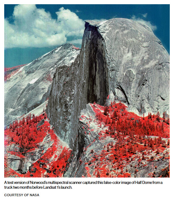
- Landsat and Virginia Tower Norwood
President Reagan moves to cancel Landsat, George Brown acts to continue Landsat
George Brown's political action saved the Landsat program. The Congressman out in front of "big science" for decades was a key figure in the Landsat program, the long-running database of imagery of Earth that is moving on to its fifth decade with Landsat 9 (and open access) as a result of Brown's efforts. On the House science committee for over 30 years, George led an array of science efforts, including one that greens look to as prescient -- he drafted legislation establishing the first national climate change research program via the National Climate Program Act of 1978. Congressman Brown, from 1964 until his untimely passing in 1999, was a mentor for your GreenPolicy Siterunner.
○
Big Picture Visionaries from California
Two who worked to make Earth Science from Space a reality, George Brown, California representative from East LA, and Jerry Brown, "Governor Moonbeam", per Mike Royko.
"Now some people say they're going to turn off the satellites that are monitoring the climate... low-earth phenomena, the LANDSAT and all the various measuring satellites that we have...
"Well, I remember back in 1978 I proposed a LANDSAT satellite for California. They called me 'Governor Moonbeam' because of that. I didn't get that moniker for nothing."
○
NASA: Earth Sciences

Landsat 9 will propel the program past 50 years of collecting global land cover data
A New Satellite for One of the Great U.S. Space Programs
Landsat 9 is scheduled to launch in 2021, and promises the continuity of a critical, long-running database for imagery of the Earth's surface
#EarthScience -- https://www.greenpolicy360.net/w/Category:Earth_Science_from_Space

○
Landsat Science: Gavin Schmidt EarthSky Science Communicator of the Year
EarthSky, a radio program that brings current science ideas, strategies, and research results to people worldwide, has announced the selection of Dr. Gavin A. Schmidt as the 2011 EarthSky Science Communicator of the Year. Schmidt was voted for this honor overwhelmingly by EarthSky’s Global Science Advisor committee made up of over a thousand participants.
Schmidt works on climate modeling at NASA’s Goddard Institute for Space Studies (GISS) in New York. He coauthored Climate Change: Picturing the Science in 2009. In his recent EarthSky interview, Schmidt talked about the importance of describing science as a work in progress, an ongoing process. He is convinced that sharing scientists’ stories with the public—the details of how and why they conduct their research—is as important as the results that make the news. Schmidt considers science “one of the greatest, most successful human endeavors that we’ve ever embarked upon.” While looking at graphs and equations can be an esoteric endeavor, people generally have a visceral response to images of changes in the landscape and of scientist at work.
Dr. Schmidt interviewed / March 2012 -- http://earthsky.org/earth/gavin-schmidt-on-communicating-climate-change

__________________________________________________________________
Making the Dream Real
Remembering Stewart and George, Two Who Dreamt Was Could Be -- and Made It Happen
- And here's to today's generation who are making dreams of 'big science' a living reality


○
Read More / The first decades of Earth Science from space:
#PlanetCitizen -- http://www.planetcitizen.org
○
○
How Landsat Data Can Become Amazing Maps

○
Landsat is shaping the new Google Mapping future... A science dream made real as we see change-over-time --- the Columbia Glacier
○

○
Measuring the Ocean's Depths, Landsat pioneers ocean science with Jacques Cousteau
To establish if Landsat could accurately measure ocean depth from space, simultaneous measurements from ships, divers and the satellite were needed.
Schweickart knew a coordinated bathymetry expedition was an essential step. He had honed his diving expertise while training for his Skylab mission in NASA’s water immersion facility and was enthusiastic about scuba work. Teaming with Cousteau was a natural fit.
An elaborate experiment was designed to determine definitively if multispectral data from the Landsat satellites could be used to calculate water depth. The clear waters of the Bahamas and coastal Florida were selected as the test site.
The experiment design involved two research vessels, the Calypso and Johns Hopkins University Applied Physics Lab’s Beadonyan, being in position, or “on station,” when the Landsat 1 and 2 satellites went overhead on eight different days (four consecutive days on each of two weeks).
The overall concept was simple: the research ships would use their fathometers to measure water depth at the exact same time that the satellite flew overhead and then those measurements would be compared (the simultaneous measurements eliminated any environmental or atmospheric differences that could have complicated comparisons).
Using these measurements, scientists developed mathematical models describing the relationship between the satellite data and water depth, accounting for how far the light could travel through water, and how reflective the ocean floor was.
“Particular thanks” was given to Cousteau’s team of divers in the experiment’s final report “for their dedication and expertise in the underwater phases of the experiment, without which, measurements of key experimental parameters could not have been made.”
The diving prowess of Cousteau, Delemotte, and the Calypso crew added inextricably to the realm of satellite-derived bathymetry. Because of data collected during the NASA-Cousteau expedition, charts in clear water areas around the world were updated, making sea navigation safer. It was the precision measurements made by Delemotte and Cousteau’s team of divers that made bathymetry calculations for those chart updates possible.
🌎
- Maps
- Agricultural Economics
- Agriculture
- Democratization of Space
- Earth360
- EarthPOV
- Earth Art
- Earth Day
- Earth Imaging
- Earth Observations
- Earth Science
- Earth Science from Space
- Earth System Science
- Environmental Protection
- Environmental Security
- Global Security
- GreenPolicy360
- Green Politics
- Land Use
- NASA
- NOAA
- New Definitions of National Security
- New Space
- Planet API
- Planet Citizen
- Planet Citizens
- Planet Citizens, Planet Scientists
- Policies
- Space Science and Space Physics
- US
- Whole Earth
- Youth
- Alternative Agriculture
- Aquifers
- Appropriate Technology
- Biodiversity
- Bioneers
- Biogeosciences
- Bioregionalism
- Eco-ethics
- Eco-nomics
- Ecology Studies
- Ecoregions
- EOS eco Operating System
- Energy
- Farm-Related Policies
- Food
- Food-Related Policies
- Global Warming
- Green Best Practices
- Land Ethic
- Permaculture
- Renewable Energy
- Resilience
- Sea-level Rise
- Soil
- Strategic Demands
- Sustainability
- Sustainability Policies
- Water
- Watersheds
- Wetlands
- Atmospheric Science
- Climate Change
- Climate Policy
- Geology
- Planetary Science