Category:Earth Science from Space
Earth Sciences from Space

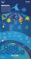
Geoscience -- #Earth360: Eyes in the Sky, Monitoring the Earth by Satellite
Updated - August 2014
Earth Imaging -- Micro-satellites [1]
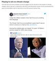
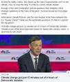
Nextgen #earthscience in era of #climatechange and #globalsecurity threat
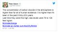
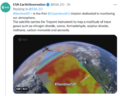
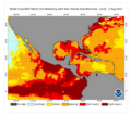
Observing Global Warming with #OCO-2 Historic launch #planetcitizen mission to study #earthsatmosphere
"First Light!" [2] [3] OCO-2 tweets - https://twitter.com/IamOCO2 OCO-2 announces 'We have data!'
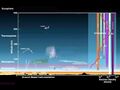
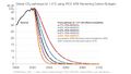
What monitoring a potential existential crisis looks like...spectra from #OCO-2 #Earth360 [4]
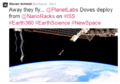
Earth observing satellites, the "Afternoon Constellation", the "A-Train" joined by #OCO-2 newly launched and historic in its mission to study global warming Orbiting Carbon Observatory
Looking closer at OCO-2 [5] [6] [7]
Earth science data is coming in and being openly distributed. Take up the challenge, perhaps with NEX here and multiple venues that are being made available for the first time.
Add your resources. With the launch of OCO-2, a 'game changer', the data of #Earth360 will grow in unprecedented ways.
Add your #PlanetCitizen talent to a future of seeing with an #EarthPOV -- #Earthdata enables informed decisions and policy
"You can manage only what you can measure"

http://www.greenpolicy360.net/w/NASA_EarthSciences,_Challenges_Public_to_Join_In
Ω
Geoscience Satellites -- Start-up companies
BlackBridge [8], Dauria [9], DigitalGlobe [10] [11] [12] GeoEye [13],
GeoOptics [14], NovaWurks [15], OmniEarth [16] [17] [18] [19]
OrbitLogic [20], PlanetiQ [21], Planet Lab [22] [23]
RapidEye [24], Skybox [25] [26] [27]
Teledyne [28], Tyvak Nano-Sat [29], Urthecast [30]

June 2014 Google Buys Skybox
[31]
[32]
[33]
[34]
[Background] June 18, 2013 Inside a Startup’s Plan to Turn a Swarm of DIY Satellites Into an All-Seeing Eye [35]
June 16, 2014 - Wall Street Journal / by Christopher Mims [36]
Amid the Crazy Valuations, Google Finds a Steal
By 2016 or so, Skybox will be able to take full images of the Earth twice a day, at a resolution that until last week was illegal to sell commercially — all with just a half-dozen satellites.
By the time its entire fleet of 24 satellites has launched in 2018, Skybox will be imaging the entire Earth at a resolution sufficient to capture, for example, real-time video of cars driving down the highway. And it will be doing it three times a day.
You might think, thanks to weather maps and the satellite view on Google Maps, that such imagery already is readily available. But because satellites were, until recently, so expensive to build and launch, that isn't the case. There are only nine satellites in orbit now that capture high resolution images for the commercial market, and their capabilities are regularly commandeered for national-security purposes by the U.S. government. That means most of the pictures of the Earth that you've seen are of poor quality and years out of date.
And yet, as I discovered when I visited Skybox recently at its modest, low-slung headquarters in Mountain View, Calif., satellite imagery isn't even the business in which the company's founders see themselves. As at Google, the business of Skybox isn't data, but knowledge.
"We think we are going to fundamentally change humanity's understanding of the economic landscape on a daily basis," says co-founder Dan Berkenstock...
Skybox's images will inevitably lead to apps and services no one can envision — with unknowable disruptive potential. Skybox executives tell me they hope to offer their data to outside developers... In the short term, Google has said it would use Skybox's images to improve the search company's maps.
A patent revealed in May indicates that Google builds its superaccurate maps directly from satellite imagery, and the company has long had a deal with Skybox competitor DigitalGlobe, whose satellites cost 10 times as much as Skybox's and are 10 times heavier, leading to much higher launch costs. DigitalGlobe's stock dipped 4% on news of the Skybox deal...
_ _ _ _ _ _ _ _ _ _ _ _ _ _ _ _ _ _ _ _ _
“With all these start-ups, the things you’ll be able to do with satellite images will grow exponentially..." - IEEE, May 2014
June 16, 2014
- U.S. Department of Commerce lifts ban on satellite images showing features smaller than 20 inches - DigitalGlobe [37] [38] [39] [40]
- "Companies had not been allowed to make use of images where features smaller than 50cm were visible"
- Satellites Are Cleared to Take Photos at Mailbox-Level Detail per DigitalGlobe petition
- Worldview-3 satellite is set to launch in August. Digital Globe [41] [42] says it will now be able to sell images that show features as small as 31cm [43]
- Sites like Google and Bing Maps will be able to use higher-quality satellite images in near real-time [44] [45]... eventually real-time
GP360: Earth-monitoring, data-sharing, open source, is in the wings...
Citizen-networking/schools-education space-earth projects, first-ever...
- 24/7 high-definition video of Earth <Urthecast-ISS> [46]
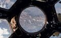
Live from the International Space Station [47] [48] [49] [50] [51]

Feb 2014 – Planet Labs
Since the launch of the original Landsat program in 1972, generating images of Earth from space has been the near-exclusive domain of enormous, multi-million dollar satellites sponsored by nations and major defense corporations.
New micro-satellites, including those launched from the ISS, aim to make real-time imaging available for a fraction of the past decades price and move us from military-defense-communication operations to earth systems-defense, monitoring, sustainability and eco-nomics functions.
Earth systems, monitoring over time - http://www.earthzine.org/geo-and-geoss-the-group-on-earth-observations-and-the-global-earth-observations-system-of-systems/
<more> http://gizmodo.com/meet-the-flockers-iss-launches-low-cost-earth-imaging-1517232660
Earth Imaging - background – 2007 - Acquiring large data sets of Earth imagery in a simple, low-cost way, represents a new market opportunity that has yet to be addressed. New telescope design enables low-cost satellite with that purpose.

Jan 2014 - "Flocking" "Doves" "Nanosatellites" - http://www.scientificamerican.com/article/flock-of-nano-satellites-to-capture-high-res-views-of-whole-earth/
Google goes mapping - http://gizmodo.com/how-swarms-of-tiny-satellites-are-creating-a-real-time-1497890594
Swarms of small satellites set to deliver close to real-time imagery - http://www.nature.com/news/many-eyes-on-earth-1.14475

Dec 2013
"How Planet Labs Is Saving the Earth with 'Homemade' Satellites. It took less than six months to build twenty-eight of them"...
<more> http://www.businessinsider.com/planet-labs-fleet-of-homemade-satellites-2013-12?op=1
http://www.space.com/23739-tiny-earth-satellite-fleet-launching-december.html
Nov 2013
Flock of Mini- and Micro-sats delivered to space with international Dnepr co-venture - http://www.space.com/23738-dnepr-rocket-launches-32-satellites.html
Minotaur 1 delivers 29 mini's/CubeSats including first-ever design/build satellite project of a US high school
http://www.orbital.com/NewsInfo/MissionUpdates/MinotaurI_ORS-3/
Sept 2013
Sensors and Systems - “Every year the technology improves, with better computers and storage and payloads. The technological evolution improves, price points continue to come down, and now with a small 150 to 300 kg spacecraft for $10 to $20 million you can do what you were doing with a 1,000 kg spacecraft five to 10 years ago for $500 million.” Surrey Satellite Technology-RapidEye satellite imagery “Changing the Economics of Space” ... co-ventures/joint ventures/'ride-alongs'/shared platforms/accessible data
<more> http://www.sstl.co.uk/ - note connection to SpaceX - Elon Musk - note Elon Muck opening up the Tesla platform on June 12, 2014 - http://en.wikipedia.org/wiki/Surrey_Satellite_Technology - http://www.teslamotors.com/blog/all-our-patent-are-belong-you
June 2013
Citizens in Space - http://www.citizensinspace.org/2013/06/planet-labs-to-launch-flock-1/
Opening up to understanding and interacting with our eco-operating systems
eOS http://www.scribd.com/doc/189078245/eOS-EcoOperatingSystem-1
_ _ _ _ _ _ _ _ _ _ _ _ _ _ _ _ _ _ _ _ _
Earth systems, monitoring over time - http://www.earthzine.org/geo-and-geoss-the-group-on-earth-observations-and-the-global-earth-observations-system-of-systems/
GEO - Group on Earth Observations - http://www.earthobservations.org/about_geo.shtml
- GEOSS - Global Earth Observation System of Systems - http://www.earthobservations.org/geoss.shtml
_ _ _ _ _ _ _ _ _ _ _ _ _ _ _ _ _ _ _ _ _ _ _ _ _ _ _ _ _ _ _ _ _ _ _ _ _ _ _ _ _

Subcategories
This category has the following 19 subcategories, out of 19 total.
A
C
D
E
G
N
O
P
S
T
W
Pages in category "Earth Science from Space"
The following 82 pages are in this category, out of 82 total.
C
- Carbon Brief
- Clearcutting
- Climate Change - Global Warming Keyword-Terms
- Climate Change Denier Talking Points -- and Rebuttals
- Climate Conference - Paris 2015
- Climate Desk
- Climate Law Blog @Columbia Law School
- Climate migration
- Climate News
- Climate News Events Archive ... 1970 to Today
- Climate Plans Enforcement - Resources
E
- Each of us can make a positive difference
- Earth
- Earth from NASA
- Earth Imaging-New Space
- Earth Right Now
- Earth Science Eco-Fields
- Earth Science Research from Space
- Earth Science Vital Signs
- EarthPOV
- EarthTime
- Earthviews
- Earthviews from Astronauts
- Environmental full-cost accounting
- Environmental Rules Rolled Back
- Environmental Security Organizations
- ESA Living Planet Announcement - May 2022
- Ethics and Climate Change
- European Union Green Deal - Fit for 55
- ExxonMobil and US House Science Committee v US Attorneys General and Environmental Groups
G
I
L
P
S
Media in category "Earth Science from Space"
The following 200 files are in this category, out of 832 total.
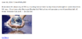
(previous page) (next page) 'Thin Blue Layer' of Earth's Atmosphere 2.jpg 800 × 486; 46 KB
 'Thin Blue Layer' of Earth's Atmosphere l.jpg 853 × 486; 46 KB
 'Thin Blue Layer' of Earth's Atmosphere xl.jpg 1,152 × 648; 79 KB
 -HelloEarth.png 579 × 381; 0 bytes
 03-Scott-Kelly-NASA.jpg 800 × 500; 113 KB
 1977 from the Office of Science and Technology Policy.jpg 661 × 711; 177 KB
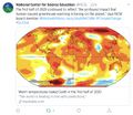
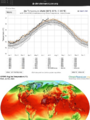
 2020 record temperatures.png 800 × 502; 358 KB
 3-15-2016 10-49-38 AM.png 702 × 862; 396 KB
 3-15-2016 12-29-07 PM.png 538 × 701; 201 KB
 5 19 14 andrew antarcticaelevationchanges-640x547.jpg 640 × 547; 59 KB
 7-20-2020 GreenPolicy360 RT No.2.jpg 591 × 510; 125 KB
 @AstroSamantha HelloEarth Jan30,2015.png 998 × 699; 851 KB
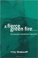 A Fierce Green Fire.jpg 208 × 314; 13 KB
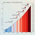
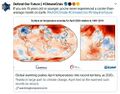
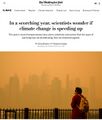 A scorching year, what about the 360 warming data.jpg 600 × 706; 106 KB
 About Baselines and Change.png 592 × 312; 33 KB
 About website of The Invading Sea.png 800 × 343; 126 KB
 Above.png 500 × 375; 173 KB
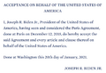 Acceptance on behalf of the United States of America.png 448 × 306; 62 KB
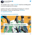
 Act now for a livable future.png 501 × 275; 272 KB
 Acting to make a positive difference - in St Petersburg Florida.png 600 × 723; 645 KB
 Actually watching the planet breathe.png 800 × 446; 649 KB
 Ag production and GHG emissions.jpg 680 × 510; 33 KB
 Against the Tide - Cover - by Cornelia Dean.jpg 308 × 475; 57 KB
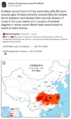
 Air pollution moves globally.png 620 × 412; 256 KB
 Alaska Willow - March 12 2023.png 576 × 230; 99 KB
 Alaska Willow News-March 12 2023.png 576 × 625; 235 KB
 Aldis zone blog.jpg 500 × 498; 67 KB
 Amazon fires burn across the rainforest.jpg 800 × 504; 76 KB
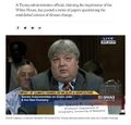
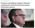 Andrew Wheeler confirmed to head EPA.jpg 753 × 600; 85 KB
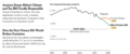
 Another year, another record.png 800 × 294; 251 KB
 Antarctica ice shelf-glaciers 2012.png 956 × 714; 805 KB
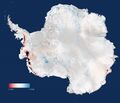
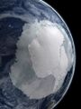 Antarctica-2018.jpg 768 × 1,024; 82 KB
 Anthropocene bks016.png 800 × 248; 227 KB
 Anthropocene-crutzen.jpg 628 × 347; 79 KB
 Anthropocene-the-geology-of-humanity.jpg 628 × 347; 79 KB
 AOC re climate task force - july 8 2020.jpg 585 × 203; 38 KB
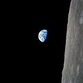 Apollo Earth 350x350.jpg 350 × 350; 32 KB
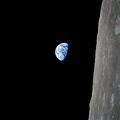 Apollo.jpg 715 × 715; 102 KB
 April 28, 2016.png 586 × 415; 159 KB
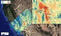
 Aquifers earthsciencefromspace Grace CA3.png 772 × 652; 559 KB
 Aquifers global earth observations by grace20150616-16 m.jpg 800 × 450; 117 KB
 Aquifers global earth observations by grace20150616-16.jpg 1,600 × 900; 317 KB
 Aquifers globalstudy 2015.png 668 × 451; 299 KB
 Aquifers June2015 past the tipping point.png 533 × 615; 195 KB
 Arctic - Antarctic - Breaking.png 639 × 600; 903 KB
 Arctic - Kolbert - 2023.png 553 × 476; 274 KB
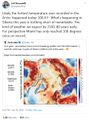
 Arctic 30.1 C at 62.5 N.jpg 800 × 432; 80 KB
 Arctic drilling ban Dec 21, 2016.png 692 × 536; 119 KB
 Arctic heat in Russia-Siberia 2020.gif 784 × 408; 3.6 MB
 Arctic Melt - 1950-2020.png 640 × 349; 287 KB
 Arctic Sea Ice 2015.png 1,008 × 756; 542 KB
 Arctic Sea Ice Area graphic thru 2016.png 640 × 355; 382 KB
 Arctic sea ice watch 25 yrs of ice cover change.png 697 × 386; 314 KB
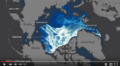
 Arctic Sea Ice.png 525 × 103; 97 KB
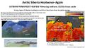 Arctic Siberia Heatwave - Again - June 2021.jpg 640 × 360; 83 KB
 Arctic-March30,2019.jpg 797 × 600; 126 KB
 Arctic-Siberia-6-20-2020.jpg 478 × 644; 148 KB
 Arctic-swipa-spm.pdf ; 4.58 MB
 AskNatureAvatar s.png 200 × 200; 14 KB
 Atmosphere Science.jpg 800 × 600; 45 KB
 Atmospheric Experiment of Humanity.jpg 519 × 574; 201 KB
 AU Too Hot.png 640 × 413; 286 KB
 Away fly the Doves March4,2015.png 582 × 409; 167 KB
 Banking - finance - climate - Mann-1.jpg 452 × 640; 162 KB
 Banking - finance - climate - Mann-2.jpg 452 × 640; 164 KB
 Barrier island hubris 6-29-2021.jpg 490 × 635; 111 KB
 Biden - clean energy ambitions.JPG 640 × 334; 31 KB
 Biden introduces leadership team - Nov 24 2020.jpg 800 × 644; 173 KB
 Biden re Earth Day 2023.png 640 × 400; 155 KB
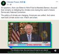
 Biden selects Kerry as special climate envoy.jpg 592 × 505; 87 KB
 Biden urged to act - Oct 18 2021 - The Guardian.png 663 × 600; 497 KB
 Biden's assembled an all-star climate team 4-21-2021.jpg 682 × 732; 309 KB
 Biden-Sanders Unity Task Force on Climate.jpg 701 × 780; 139 KB
 Big Oil Rocked by News May 27 2021.jpg 639 × 600; 84 KB
 Bill McKibben switches gears-Sept 2021.jpg 518 × 265; 78 KB
 Bill Nelson on Global Temp Rise and Climate Change.png 640 × 353; 100 KB
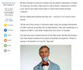
 Bill Nye explains.jpg 543 × 508; 88 KB
 Bill Nye The Planet's on Fire.jpg 800 × 675; 106 KB
 Bloomberg Carbon Clock 10-26-2021 8-47-05 AM EST.png 800 × 195; 356 KB
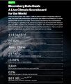 Bloomberg Live Climate Data Dashboard.jpg 640 × 756; 156 KB
 Blue Horizon Sept21,2015 by Astro Scott Kelly.jpg 1,023 × 681; 11 KB
 Blue-Green & Planet Citizens, Planet Scientists.png 549 × 844; 94 KB
 Brazil INDC 2015.png 592 × 366; 301 KB
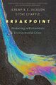 Breakpoint - Reckoning with America's Environmental Crisis.jpg 329 × 500; 49 KB
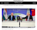
 Bridenstine talks.png 1,485 × 911; 223 KB
 Burst of climate denial as Trump presidency ends.jpg 632 × 604; 92 KB
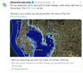
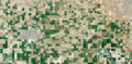 California's Central Valley Earth View June 2015.png 1,571 × 767; 0 bytes
 California's kelp forests and coastal biodiversity diminished.png 532 × 754; 307 KB
 Car heating and cooling.png 465 × 635; 261 KB
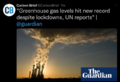 Carbon Brief - Greenhouse gas levels 2021.png 640 × 436; 292 KB
 Carbon Clock March 23, 2017.png 800 × 194; 44 KB
 Carbon Footprint - BP-McKibben-Solnit-Aug2021.jpg 516 × 264; 66 KB
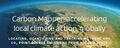 Carbon Mapper - Launch - April 2021.jpg 800 × 323; 92 KB
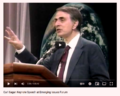
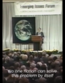 Carl Sagan at the Emerging Issues Forum - 1990.png 360 × 460; 192 KB
 Carl Sagan at the Emerging Issues Forum.png 747 × 600; 600 KB
 Carl Sagan, 1985.PNG 480 × 566; 331 KB
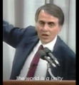 Carl Sagan, the atmosphere unifies and connects all of our world.png 360 × 390; 229 KB
 CCI-June29,2016.png 760 × 902; 201 KB
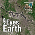 Celebrating 50 Years of Landsat.png 600 × 610; 909 KB
 CFCs then HFCs.png 800 × 382; 169 KB
 CFSV2 world temp July 3, 2023.png 600 × 800; 513 KB
 CH4 graph - 1980-2020.JPG 640 × 446; 22 KB
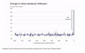 Changes in carbon dioxide per 1000 years - via Climate Central.jpg 682 × 424; 34 KB
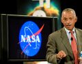 Charles Bolden.jpg 575 × 449; 153 KB
 Chasing Coral.jpg 800 × 437; 65 KB
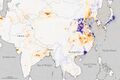 China air 2005 2014.jpg 720 × 480; 160 KB
 China Record Heat - August 2022.png 800 × 1,343; 812 KB
 Chloro1.jpg 432 × 216; 71 KB
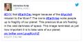 Christina Korp Earth Day and Apollo 8.jpg 519 × 264; 80 KB
 Citizens Climate Lobby - Tampa Bay.jpg 586 × 515; 125 KB
 Climate Action 25th conf in Madrid.jpg 680 × 510; 22 KB
 Climate activist - Steven Schmidt - 1978 on.png 600 × 480; 174 KB
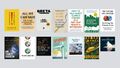 Climate Books - 2020.jpg 800 × 450; 69 KB
 Climate Change Agr Nov 4, 2016.png 800 × 523; 296 KB
 Climate Change Conf Nov 6-17.png 464 × 488; 107 KB
 Climate Change COP27 - Nov 11 2022 US Representatives.jpg 712 × 444; 54 KB
 Climate Change COP27 - Nov 11 Kathy Castor.jpg 712 × 710; 77 KB
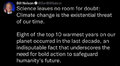
 Climate change unique threat to national security.png 800 × 42; 20 KB
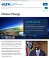 Climate Change US EPA.jpg 600 × 703; 95 KB
 Climate Conferences 1979-2020.jpg 768 × 768; 121 KB
 Climate Crisis - Emily Atkin Heated No. 1.jpg 537 × 453; 61 KB
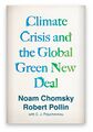 Climate Crisis and the Global Green New Deal.jpg 293 × 418; 33 KB
 Climate debate.jpg 493 × 580; 129 KB
 Climate Desk.jpg 390 × 226; 21 KB
 Climate diplomacy is failing - June 2020.jpg 592 × 440; 71 KB
 Climate Emergency Institute - Oct 2022.png 610 × 600; 274 KB
 Climate Emergency Institute -- 2021.jpg 800 × 450; 55 KB
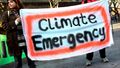 Climate emergency.jpg 800 × 450; 69 KB
 Climate Headline News around the World - July 2023.jpg 600 × 704; 151 KB
 Climate Lawsuit-Our Childrens Trust-Florida.png 462 × 760; 289 KB
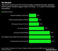 Climate Models.png 639 × 558; 123 KB
 Climate News - Oct 28 2022.jpg 626 × 600; 88 KB
 Climate News - United Nations Report - Feb 2022.png 768 × 878; 539 KB
 Climate News Dec 4 2023 in Dubai.png 800 × 1,037; 649 KB
 Climate Plan pledges as Oct6,2015.png 529 × 409; 101 KB
 Climate Plans Enforcement - Resources - GreenPolicy.png 768 × 897; 686 KB
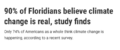 Climate poll - Florida.png 640 × 267; 36 KB
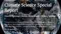 Climate Science Special Report - US - November 2017.jpg 800 × 445; 122 KB
 Climate strike - Week 171.png 739 × 600; 834 KB
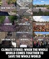 Climate Strike Around the World - Sep20,2019.jpg 700 × 830; 119 KB
 Climate Summit - Leonardo DiCaprio.png 600 × 663; 521 KB
 Climate Summit live updates - Nov 2 2021.png 751 × 600; 420 KB
 Climate Summit planned-1.jpg 800 × 301; 53 KB
 Climate Summit planned-2.jpg 800 × 187; 31 KB
 Climate Summit planned-3.jpg 800 × 278; 44 KB
 Climate Summit planned-4.jpg 800 × 241; 41 KB
 Climate usa 60 years on.jpg 800 × 480; 34 KB
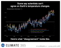 Climate365 NASA and science orgs measure and monitor.png 798 × 633; 165 KB
 ClimateNews 360.jpg 172 × 172; 9 KB
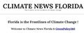 ClimateNewsFlorida.jpg 448 × 191; 36 KB
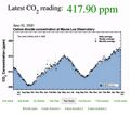 CO2 at Mauna Loa data - June 02, 2020 - 417.90 ppm.jpg 640 × 566; 66 KB
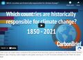 CO2 cumulative emissions 1850 - 2021 - countries.jpg 640 × 462; 211 KB
 CO2 Emissions per Capita by Country 1960-2014.png 800 × 451; 424 KB
 CO2 emissions-around-the-world.png 800 × 595; 123 KB
 CO2 global pathways via IPCC AR6 - how will we respond.jpg 800 × 450; 57 KB
 CO2 higher than in the past 5 million yrs.jpg 514 × 285; 62 KB
 Coastal Connecticut sea level rise.png 480 × 549; 396 KB
 Congressman george.e.brown.gif 235 × 305; 41 KB
 COP26 Climate Summit concludes.jpg 600 × 800; 160 KB
 COP26 concludes - 2.png 648 × 467; 177 KB
 COP26 concludes - 3.png 648 × 713; 416 KB
 COP26 concludes.png 648 × 528; 329 KB
 COP26 in GLASGOW - 31 OCT-12 NOV 2021.jpg 800 × 264; 51 KB
 COP27 'opening speech'.png 640 × 460; 160 KB
 COP28 News - Dec 13 2023.png 800 × 898; 410 KB
 CopernicusEU - Sentinel5P Atmosphere Monitoring Mission - 2.jpg 795 × 1,477; 654 KB
 CopernicusEU - Sentinel5P Atmosphere Monitoring Mission.png 583 × 465; 222 KB
 Coral bleaching - August 2023.png 488 × 430; 261 KB
 Coral bleaching - NOAA - August 2023.png 488 × 338; 201 KB
 Covering Climate Now.jpg 493 × 498; 67 KB
 Cradle of Civilization - and climate change.jpg 640 × 360; 70 KB
 CSDA Program and Planet.jpg 800 × 379; 99 KB
 Cube Launch from the ISS via Tim Peake.png 640 × 409; 218 KB
 Cumulative CO2 Emissions by Country Since 1850.png 800 × 445; 445 KB
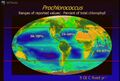 Cyanobacteria Prochlorococcus worldmapping MIT.jpg 473 × 321; 60 KB
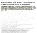 Dated record of Earths climate - Science Report Sept 10 2020.jpg 735 × 669; 192 KB
 Day before Earth Day, April 21, 2015.png 1,275 × 752; 1.66 MB
 Day before Earth Day-m April 21, 2015.png 800 × 472; 896 KB
 Dead Sea evaporation ponds.jpeg 800 × 600; 170 KB
 Death Valley ... the heat, what its like.jpg 640 × 381; 62 KB
 Defend Our Future 6-1-2020.jpg 585 × 458; 103 KB
 Democratic Climate Plan-Introduced June 2020.jpg 528 × 561; 117 KB
 Democratic National Convention-62 climate speakers.jpg 443 × 407; 57 KB
 Democratic Party Climate Bill - Aug 2022.png 640 × 269; 70 KB
 Democratic Party pres candidates debate in Miami-June 2019.jpg 800 × 534; 124 KB
 Democratic presidential candidates on the Green New Deal.jpg 800 × 359; 57 KB
 Democratising access to information about the planet Planet Labs.jpg 804 × 452; 43 KB
 Denying human-caused climate change.jpg 639 × 620; 129 KB
 Diane Walder in Miami Beach.jpg 775 × 787; 147 KB
 Discover Your Planet.png 1,176 × 608; 1.11 MB
 Don't Look Up ....jpg 430 × 543; 172 KB
 Don't Look Up.jpg 800 × 450; 104 KB


.png)


