Aquifers
Aquifers at Risk
'Water is Life'
And the Taking of Water Resources
'Heartland America', Spreading across the Central United States, Confronts Continued Depletion of Underground Water Resources
Spanning approximately 174,000 square miles across eight states from South Dakota to Texas, the Ogallala Aquifer (High Plains Aquifer) is the lifeblood of American agriculture, providing roughly 30% of all groundwater used for U.S. irrigation. However, the aquifer faces an existential crisis as massive agricultural extraction severely outpaces natural replenishment from rainfall. In some heavily farmed regions like the Texas High Plains, water levels have plunged by up to 80 meters (262 feet), leaving parts of the reservoir entirely depleted and threatening the long-term viability of the region's farming communities. The consequences of this groundwater collapse extend far beyond localized dry wells.
The Ogallala sustains a $35+ billion agricultural economy, and as the water table drops, farmers are hit with skyrocketing extraction costs and dwindling crop yields.
Without aggressive water management and shift toward sustainable farming practices, the depletion of these non-renewable resources risks destabilizing the nation's food supply and transforming once-fertile plains back into arid dust bowls.
Source: USGS
2025
Via Circle of Blue
The importance of the Ogallala Aquifer to the economy of the High Plains is difficult to understate. Spanning eight states from South Dakota in the north to Texas in the south, the Ogallala is North America’s largest source of underground fresh water. In a region with few flowing rivers and sporadic rain, its groundwater nurtures vast harvests of cotton, corn, soybeans, and wheat, in addition to some of the nation’s biggest cattle feedlots. All told, the Ogallala supports an agriculture industry worth $35 billion.
Because of limited precipitation, the Ogallala as it has been managed is essentially a finite resource, a bank account slowly being drawn down to produce immense quantities of grain. Some areas on the aquifer’s fringe are already too depleted for irrigation.
○
"America Is Using Up Its Groundwater Like There’s No Tomorrow"
Overuse is damaging, draining, and polluting aquifers nationwide, a New York Times (2022) data investigation reveals (Unlocked/Free to share)
○
GreenPolicy360 says 'water is life' and nations of the world must protect and sustain fresh water resources:
- Climate Change and Drought are Real-World Threats & Preventing Non-sustainable Overuse of Water Must Be a High Priority for All
Measure, Monitor, Manage Aquifers

- Earth Science Research from Space begins to monitor and demonstrate depletion of fresh water sources
November 2015 / For the first time since 'back-of-the-envelope' estimates of groundwater use were calculated in the 1970s, "hydrologists have produced a first 'data-driven estimate' of the Earth's total supply of groundwater..."
The challenge going forward is to develop systems that are improved to continuously monitor the use of water -- depletion and recharging-resupply -- and the social systems that are capable of developing and employing ecological economics, production systems to maintain ongoing fresh water for all needed uses, from agriculture to home, personal to business.
○
- Click on maps and graphics

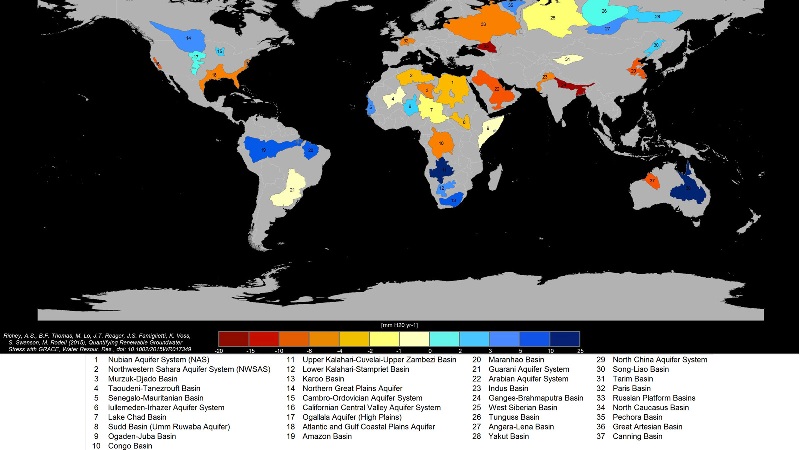

First Global Study of Aquifers from Space
"Quantifying renewable groundwater stress with GRACE", 16 June 2015
The GRACE earth observation system (EOS) mission is to measure gravity variations including:
- changes due to surface and deep currents in the ocean;
- runoff and ground water (aquifer) storage on land masses;
- exchanges between ice sheets or glaciers and the oceans; and
- variations of mass within the Earth.
An additional goal of the mission is to create a better profile of the Earth's atmosphere.
"The results from GRACE make a huge contribution to NASA's Earth science goals, Earth Observation System (EOS) and global climate change studies."
○ ○ ○ ○ ○ ○ ○ ○ ○ ○ ○ ○ ○ ○ ○ ○ ○
Earth Aquifer Observations / June 2015
The world’s largest underground aquifers – a source of fresh water for hundreds of millions of people — are being depleted at alarming rates, according to new NASA satellite data that provides the most detailed picture yet of vital water reserves hidden under the Earth’s surface.
Twenty-one of the world’s 37 largest aquifers — in locations from India and China to the United States and France — have passed their sustainability tipping points, meaning more water was removed than replaced during the decade-long study period, researchers announced Tuesday. Thirteen aquifers declined at rates that put them into the most troubled category. The researchers said this indicated a long-term problem that’s likely to worsen as reliance on aquifers grows.
Scientists had long suspected that humans were taxing the world’s underground water supply, but the NASA data was the first detailed assessment to demonstrate that major aquifers were indeed struggling to keep pace with demands...
“The situation is quite critical,” said Jay Famiglietti, senior water scientist at NASA’s Jet Propulsion Laboratory in California and principal investigator of the University of California Irvine-led studies.
Problems with groundwater are exacerbated by global warming, which has caused the regions closest to the equator to get drier and more extreme latitudes to experience wetter and heavier rains. A self-reinforcing cycle begins.
People living in mid-range latitudes not only pump more water from aquifers to contend with drier conditions, but that water — once removed from the ground — also then evaporates and gets recirculated to areas far north and south...
○
Underground aquifers supply 35 percent of the water used by humans worldwide...
The researchers used NASA’s GRACE satellites to take precise measurements of the world’s groundwater aquifers. The satellites detected subtle changes in the Earth’s gravitational pull, noting where the heavier weight of water exerted a greater pull on the orbiting spacecraft. Slight changes in aquifer water levels were charted over a decade, from 2003 to 2013.
“This has really been our first chance to see how these large reservoirs change over time,” said Gordon Grant, a research hydrologist at Oregon State University, who was not involved in the studies...

○
Many previous studies of groundwater storage relied on statistical calculations and looked mostly at how much water was being pumped from the ground. These limited estimates were too uncertain to improve groundwater management, researchers said. For example, past storage estimates for the Northwest Sahara Aquifer System ranged from 10 to 21,000 years.
"This work clearly demonstrates that it is no longer adequate to continue citing decades-old ... estimates of total groundwater storage," according to the new studies, which were published in the journal Water Resources Research.
Studies used 11 years of data from NASA satellites and included a number of other factors, such as population, climate and how people use water.
The twin satellites — known as Gravity Recover and Climate Experiment, or GRACE, satellites — orbit the Earth and measure the gravitational pull of water over time. The difference in measurements over time shows how much water the aquifers are gaining or losing...
○
Aquifer depletion and solutions http://earthsky.org/human-world/bridget-scanlon-on-the-accelerating-depletion-of-groundwater-worldwide -- http://web.mit.edu/12.000/www/m2012/finalwebsite/solution/groundwater.shtml -- http://news.utexas.edu/2012/05/29/groundwater
Aquifers-- https://en.wikipedia.org/?title=Aquifer
Industrial agriculture globally: Water and Agriculture
One of the issues rarely confronted when considering high intensive agriculture is the use of water in unsustainable irrigation. The draw down and depletion of aquifers is a rising cost and only recently, with the advent of earth observation and monitoring systems, are technologies becoming available to measure the extent of groundwater basins and recharging capabilities. The new satellite measurements of aquifers/ground water globally, as are now being reported with NASA GRACE satellites, comprise both a warning and a capability of needed sustainable environmental security. Water saving and water security are essential to a lasting agriculture policy...
○ ○ ○ ○ ○ ○ ○


○
Drop in U.S. underground water levels has accelerated: USGS
- http://www.greenpolicy360.net/w/File:USGS_Groundwater_depletion_map_2013.png
- http://research.msu.edu/saving-the-great-plains-water-supply-2/

- Large areas of the Ogallala Aquifer, one of the most important sources of water for agricultural crops in the United States, are at risk of drying up if the aquifer continues to be drained at its current rate.
- The Ogallala, also known as the High Plains Aquifer (HPA), spans from Texas to South Dakota and provides water to grow $35 billion in crops each year. However, since the 1950s, when high-volume pumping began, the HPA’s saturated volume has declined by roughly the volume of Lake Erie...

More:
Agriculture, Farms & Farming, Food & Food Production, Soil, Sustainability Policies, Water & Water Saving

Agriculture[edit]


- Agricultural Economics
- Agriculture
- Aquifers
- Citizen Science
- Climate Change
- Climate Smart Agriculture
- Desertification
- Earth360
- Earth Observations
- Earth Science
- Earth Science from Space
- Ecological Economics
- Ecology Studies
- Eco-nomics
- Economic Development
- Environmental Full-cost Accounting
- Environmental Security
- Environmental Security, National Security
- EOS eco Operating System
- Farm-Related Policies
- Food
- Food-Related Policies
- Geophysics and Geochemistry
- Geology
- Geophysics
- Green Politics
- Health
- Hydrology
- Kansas
- Natural Resources
- Permaculture
- Planet API
- Planet Citizen
- Planet Scientist
- Planet Citizens, Planet Scientists
- Planetary Science
- Soil
- Sustainability
- Sustainability Policies
- Virtual Earth
- Virtual Planet
- US
- Water
- Water Quality
- Water Saving
- Wetlands
- Whole Earth