Weather - Global Forecast System Visualized: Difference between revisions
Siterunner (talk | contribs) No edit summary |
Siterunner (talk | contribs) No edit summary |
||
| (6 intermediate revisions by the same user not shown) | |||
| Line 6: | Line 6: | ||
'''Weather -- Global Forecast System Visualized''' | '''Weather -- Global Forecast System Visualized''' | ||
http://en.wikipedia.org/wiki/Global_Forecast_System | * http://en.wikipedia.org/wiki/Global_Forecast_System | ||
http://www.slate.com/blogs/future_tense/2013/12/18/global_wind_map_cameron_baccario_s_visualization_of_world_weather_patterns.html | * http://www.slate.com/blogs/future_tense/2013/12/18/global_wind_map_cameron_baccario_s_visualization_of_world_weather_patterns.html | ||
🌎 | |||
http://earth.nullschool.net/ | |||
<big><big>'''Global / Planet Earth'''</big></big> | |||
* http://earth.nullschool.net/ | |||
User tips: Click on the “Earth” box at the map’s lower left corner. That opens up the map to a wider view. Click “Earth” again, and you’ll get a bunch of visualization options, including looking at ocean currents or viewing the winds at different atmospheric pressure layers (the view below shows surface winds, but take a look at the 500-millibar level, for instance, to see how fast the winds are moving high overhead). The line marked “control” lets you set the visualization time: click on “Now” to see conditions at the most recent update (the visualization is refreshed from new data every three hours), and click on the arrows to go back in time or forward (future views use data from forecast models). | User tips: Click on the “Earth” box at the map’s lower left corner. That opens up the map to a wider view. Click “Earth” again, and you’ll get a bunch of visualization options, including looking at ocean currents or viewing the winds at different atmospheric pressure layers (the view below shows surface winds, but take a look at the 500-millibar level, for instance, to see how fast the winds are moving high overhead). The line marked “control” lets you set the visualization time: click on “Now” to see conditions at the most recent update (the visualization is refreshed from new data every three hours), and click on the arrows to go back in time or forward (future views use data from forecast models). | ||
| Line 21: | Line 24: | ||
[[File:Earth2.png | link=http://earth.nullschool.net/]] | [[File:Earth2.png | link=http://earth.nullschool.net/]] | ||
<big><big>'''Weather Satellites'''</big></big> | |||
* https://en.wikipedia.org/wiki/Weather_satellite | |||
* https://en.wikipedia.org/wiki/Earth_observation_satellite | |||
* https://en.wikipedia.org/wiki/List_of_Earth_observation_satellites | |||
Meteorological Satellites (List of Weather Satellites) | |||
* https://commons.wikimedia.org/wiki/Category:Meteorological_satellites | |||
NOAA GOES Satellite Servers Data | |||
* https://www.star.nesdis.noaa.gov/goes/ | |||
* https://www.goes.noaa.gov/ | |||
* https://www.goes.noaa.gov/sat-explanation.html | |||
* https://www.goes.noaa.gov/f_himawari-8.html | |||
* https://www.goes.noaa.gov/msg.html | |||
Archive / Wayback Machine / InternationalWeatherArchive.org (with viewer) | |||
* https://web.archive.org/web/20100201214229/http://internationalweatherarchive.org/satellites/goesEast.aspx | |||
* https://web.archive.org/web/20100202021807/http://internationalweatherarchive.org/satellites/goesWest.aspx | |||
* https://web.archive.org/web/20100202032428/http://internationalweatherarchive.org/satellites/meteosat7.aspx | |||
* https://web.archive.org/web/20100202032500/http://internationalweatherarchive.org/satellites/meteosat9.aspx | |||
* https://web.archive.org/web/20100202032505/http://internationalweatherarchive.org/satellites/mtsat1R.aspx | |||
🌎 | |||
: [[File:Hurricanes - Typhoons via NASA data.png]] | |||
[[Category:Climate Change]] | [[Category:Climate Change]] | ||
[[Category:Countries]] | |||
[[Category:Earth Observations]] | [[Category:Earth Observations]] | ||
[[Category:Earth Science]] | [[Category:Earth Science]] | ||
[[Category:Planet Citizen]] | [[Category:Planet Citizen]] | ||
[[Category:Planet Scientist]] | [[Category:Planet Scientist]] | ||
[[Category:Anthropocene]] | |||
[[Category:Aquifers]] | |||
[[Category:Atmospheric Science]] | |||
[[Category:Building Standards]] | |||
[[Category:Climate Change]] | |||
[[Category:Climate Policy]] | |||
[[Category:Cryosphere]] | |||
[[Category:Divestment from Fossil Fuels]] | |||
[[Category:Earth]] | |||
[[Category:Earth360]] | |||
[[Category:Earth Imaging]] | |||
[[Category:Earth Observations]] | |||
[[Category:Earth Science]] | |||
[[Category:Earth Science from Space]] | |||
[[Category:Eco-nomics]] | |||
[[Category:Ecology Studies]] | |||
[[Category:Environmental Full-cost Accounting]] | |||
[[Category:Environmental Protection]] | |||
[[Category:Environmental Security]] | |||
[[Category:Environmental Security, National Security]] | |||
[[Category:ESA]] | |||
[[Category:Global Security]] | |||
[[Category:Green Best Practices]] | |||
[[Category:Green Politics]] | |||
[[Category:Land Use]] | |||
[[Category:NASA]] | |||
[[Category:Nature]] | |||
[[Category:New Definitions of National Security]] | |||
[[Category:NOAA]] | |||
[[Category:Ocean Ecosystem]] | |||
[[Category:Oceans]] | |||
[[Category:Ocean Science]] | |||
[[Category:Planet Citizens]] | |||
[[Category:Planet Scientist]] | |||
[[Category:Planet Citizens, Planet Scientists]] | |||
[[Category:Renewable Energy]] | |||
[[Category:Resilience]] | |||
[[Category:Sea-level Rise]] | |||
[[Category:Sea-Level Rise & Mitigation]] | |||
[[Category:Solar Energy]] | |||
[[Category:Strategic Demands]] | |||
[[Category:Sustainability]] | |||
[[Category:Sustainability Policies]] | |||
[[Category:US Environmental Protection Agency]] | |||
[[Category:Whole Earth]] | |||
Latest revision as of 14:56, 12 July 2022
Weather -- Global Forecast System Visualized
🌎
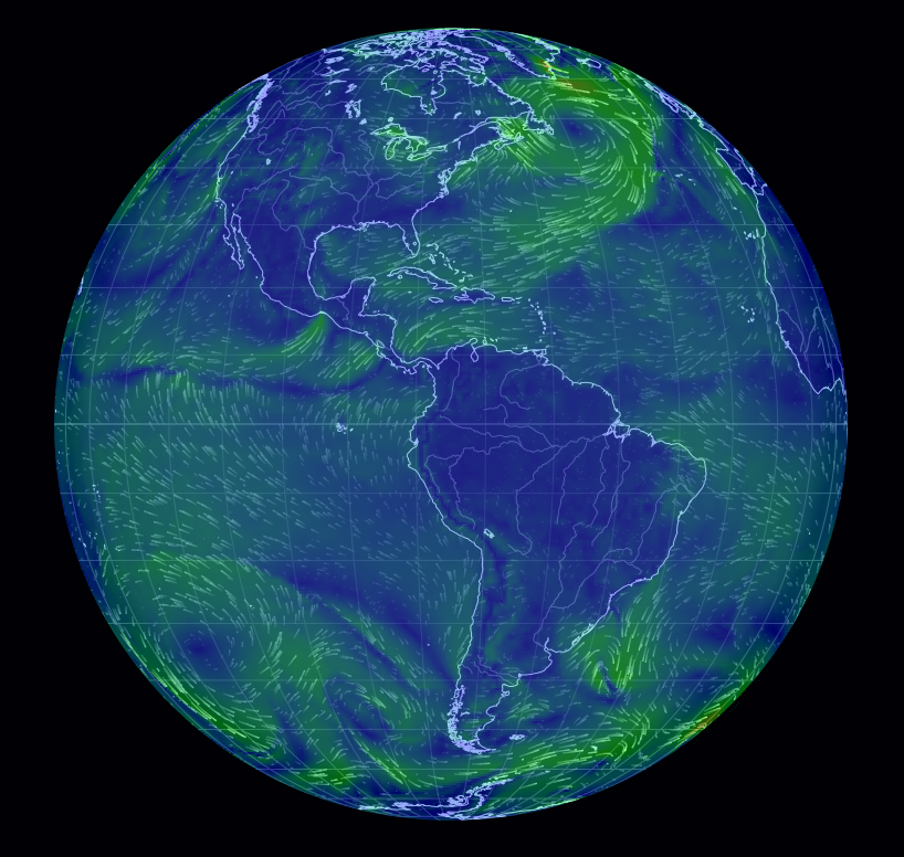
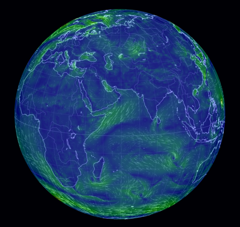
Global / Planet Earth
User tips: Click on the “Earth” box at the map’s lower left corner. That opens up the map to a wider view. Click “Earth” again, and you’ll get a bunch of visualization options, including looking at ocean currents or viewing the winds at different atmospheric pressure layers (the view below shows surface winds, but take a look at the 500-millibar level, for instance, to see how fast the winds are moving high overhead). The line marked “control” lets you set the visualization time: click on “Now” to see conditions at the most recent update (the visualization is refreshed from new data every three hours), and click on the arrows to go back in time or forward (future views use data from forecast models).
Weather Satellites
Meteorological Satellites (List of Weather Satellites)
NOAA GOES Satellite Servers Data
Archive / Wayback Machine / InternationalWeatherArchive.org (with viewer)
🌎

- Climate Change
- Countries
- Earth Observations
- Earth Science
- Planet Citizen
- Planet Scientist
- Anthropocene
- Aquifers
- Atmospheric Science
- Building Standards
- Climate Policy
- Cryosphere
- Divestment from Fossil Fuels
- Earth
- Earth360
- Earth Imaging
- Earth Science from Space
- Eco-nomics
- Ecology Studies
- Environmental Full-cost Accounting
- Environmental Protection
- Environmental Security
- Environmental Security, National Security
- ESA
- Global Security
- Green Best Practices
- Green Politics
- Land Use
- NASA
- Nature
- New Definitions of National Security
- NOAA
- Ocean Ecosystem
- Oceans
- Ocean Science
- Planet Citizens
- Planet Citizens, Planet Scientists
- Renewable Energy
- Resilience
- Sea-level Rise
- Sea-Level Rise & Mitigation
- Solar Energy
- Strategic Demands
- Sustainability
- Sustainability Policies
- US Environmental Protection Agency
- Whole Earth