File:Reefscape.png
Reefscape.png (582 × 567 pixels, file size: 537 KB, MIME type: image/png)
<addthis />
Coral Reefs in Danger:
- Earth Research from Space Takes on the Challenge
Leonardo DiCaprio, Planet Citizen
Reefscape
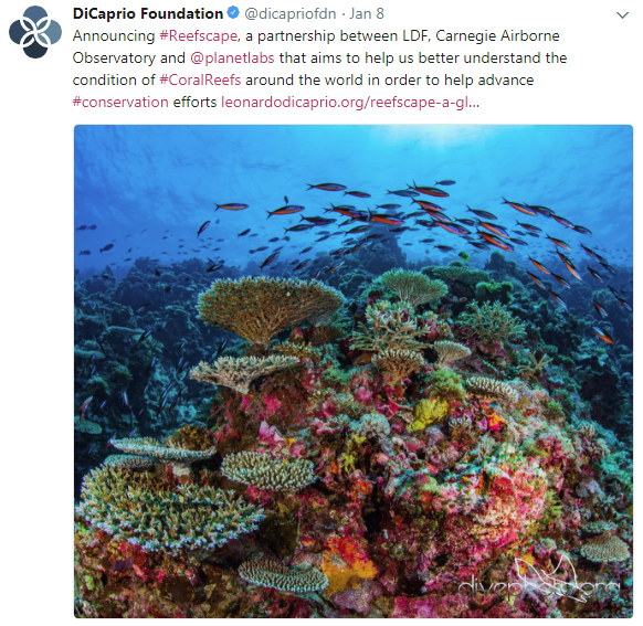
Despite our growing knowledge of how coral reefs are changing around the world, the geography of these changes remains extremely hard to piece together. Reefs in one region respond to stressors differently than reefs in another, and within a reef, individual species react differently. During coral-bleaching events, for example, there are often winners and losers within a given reef, making it difficult to predict whether the ecosystem as a whole will bounce back. This variation among corals is matched by unknown variation among key reef-dwelling fish and invertebrates, the fates of which are linked to that of corals. Given that coral reefs span an estimated 500,000 square kilometers (193,000 square miles) in total area, spread over more than 200 million square kilometers (77.2 million square miles) of ocean, it is no wonder that the state of global reefs remains poorly known today.
To gather a more comprehensive understanding of the condition of global reef ecosystems, we need a way to assess and monitor them on a large geographic scale. New satellites, such as those from Planet (formerly Planet Labs), are, as of 2017, able to capture near-daily imagery of coral reefs worldwide. Planet’s high-resolution imagery of reef location provides us with an at-your-fingertips understanding of the extent of shallow, horizontally oriented reefs. Satellites miss the vertically inclined reefs — the so-called reef walls — but are evolving to facilitate monitoring the most vulnerable shallow horizontal reef areas over time. Currently, no satellites can provide a way to assess reef health at the resolution of individual or clusters of corals and other reef inhabitants. For this, we need a new satellite mission.
With our partners, we are planning a new satellite mission for global reef ecosystems, a mission that will advance our ability not only to map reef extent, as we can do now with Planet’s current fleet of satellites, but also to monitor changes in coral reef health.
The mission concept centers on global-scale reef monitoring using detailed spectral information, which we and others have advanced from high-flying aircraft.
A high-tech approach called imaging spectroscopy measures the spectrum of sunlight scattered and absorbed by an object. These spectral patterns differ based on a given object’s unique chemical signature, and so can be used to assess changes in reef health over time.
Earth Science Research from Space
Planet Citizens, Planet Scientists
···································

File history
Click on a date/time to view the file as it appeared at that time.
| Date/Time | Thumbnail | Dimensions | User | Comment | |
|---|---|---|---|---|---|
| current | 16:04, 12 January 2018 | | 582 × 567 (537 KB) | Siterunner (talk | contribs) |
You cannot overwrite this file.
File usage
The following 11 pages use this file:
- Anthropocene
- Atmospheric Science
- Biodiversity
- Bioneers
- Biosphere
- Citizen Science
- Climate Change
- Climate Policy
- Earth Observations
- Earth Science
- Earth Science from Space
- Ecology Studies
- Environmental Full-cost Accounting
- Environmental Security, National Security
- EOS eco Operating System
- Externalities
- Geoengineering
- PlanetLabs
- Planet API
- Planet Citizen
- Planet Scientist
- Planet Citizens, Planet Scientists
- Sea-Level Rise & Mitigation
- Sustainability
- Sustainability Policies
- ThinBlueLayer