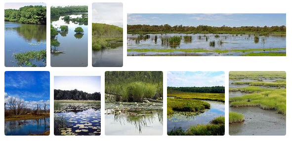
Living coastline
The terms “coastline” and “shoreline” are often used interchangeably, but they have different meanings. The coastline of a place is defined as the boundary between the coast and the shore. In other words, a coastline is a big-picture view of the approximate line between the land and the sea. A shoreline is an ever-changing line that marks the specific place where the water and shore meet...
Also visit Sea-Level Rise @GreenPolicy360
Living Shorelines, Natural Defenses, Smart Design
····················
2024
The Word Is Getting Out -- Natural Environmental Defenses Are Smart Solutions
Surfrider Foundation gives Florida a D- grade in coastal management
Florida relies heavily on sand replenishment and would benefit from drastically increasing funding to implement dune restoration and living shoreline projects to lessen its need for beach fill.
It found that “Florida has decent regulations to guide development” but there are loopholes that should be closed. The report also recommends other changes, such as incentivizing nature-based solutions and coastal restoration.
(Full disclosure: In the 1980s, the founder of GreenPolicy360 was involved in the initial years of the Surfrider Foundation:
····················
2023
GreenPolicy360: Join Our "Living Coastlines, Living Shorelines" Action
- Managed Wetlands Can Protect Shorelines and Communities
- Eco-system Designs (e.g. Mangrove biospheres) Are Natural Solutions
- Eco-systems Proved Defense Against Hurricanes/Typhoons/Extreme Weather/Ocean Surges/Flooding
- Eco-systems Managed with Local Support Can Work Better than Sea Walls and Constructed Barriers
····················
2022

Mangroves and Living Coastlines, Living Shorelines
Mapping Missing Mangroves
The Landsat program’s 50 years of Earth observations have revolutionized the study of long-term global change, including the losses and gains of tidal wetlands...
Read about the historic Landsat program, its vision, goals, mission and Earth imaging/Earth science data
Landsat info and resources @GreenPolicy360
Visit NASA Earth Observatory
Mapping Mangroves by Satellite
Downloads from NASA
Mapping mangroves using Landsat / Sentinel 1&2
Mapping the Mighty Mangroves | Landsat Science
Landsat Enables World’s Most Comprehensive Mangrove Assessment
- https://landsat.gsfc.nasa.gov/article/landsat-enables-worlds-most-comprehensive-mangrove-assessment/
··················································································

- Landsat, 50+ years of measuring and monitoring
- Providing observation data of coastlines and wetlands change
- 'Measuring and Monitoring to Manage' ... #EarthScience

Planet Citizens, Planet Scientists, Preserving & Protecting the Home Planet Earth
GreenPolicy360: The original Mission Statement of the newly launched U.S. space program spoke of our planet and our responsibilities. GreenPolicy360's founder was fortunate, beginning in the 1960s, to listen to Congressman Brown Congressman George E. Brown point to the NASA plan and explain how he saw Congress put into action the reality of a multi-year, coordinated, multi-agency program to achieve mission goals. Earth science, measuring and monitoring Earth's life-enabling systems was given highest priority. Landsat's program was set in motion as a decades long, first-ever digital scanning remote satellites data collecting study. An array of satellites began to launch, creating and combining the expanding resources of NASA, USGS, NOAA, and an array of educational and scientific institutions and aeronautics business.
The overall goal, Representative Brown would continue to explain in his Congressional Science, Space & Technology leadership roles over the decades, was to understand, preserve and protect our planet as we, humanity, develop the science to look beyond the Earth and study 'the heavens'.
Steve Schmidt, GreenPolicy360 founder, writes of "My friend George"
George E. Brown, the Congressman who pushed for, supported, and saved the Landsat earth imaging mission with its unique earth science and data collection
🌎
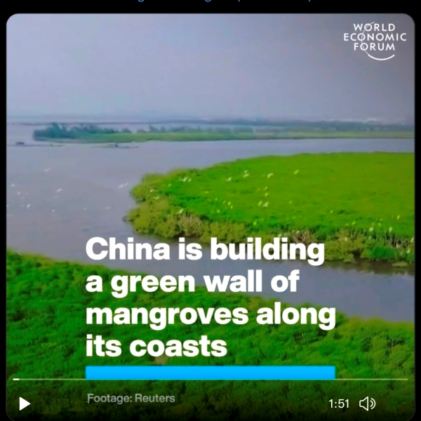
Mangroves across China's Coast Wetlands
- China is building a green wall of mangroves along its coasts
- @FriendsofOcean #MangroveWorkingGroup
·············································································
Worldview International Foundation
- Blue Carbon Climate Impact Projects in support of UN Paris Climate Agreement and UN Sustainable Development Goals
·······················································
Mangrove Tree-Planting Drones
These drones fire ‘seed missiles’ into the ground to plant up to 400K trees a day — and they're working
·····································
BioCarbon Engineering
Drones plant one billion trees a year
An ex-NASA engineer is waging war against the global scourge of industrial scale deforestation by using industrial scale reforestation to solve the problem. Lauren Fletcher plans to speed up the expensive process of hand-planting with his start-up, BioCarbon Engineering. Their motto is ‘Changing the world… 1 billion trees at a time’ and Fletcher is bringing out the big guns. Or, in this case, drones.
As 26 billion trees are currently burned down annually, with only 15 billion replanted, he has calculated his team can replant one billion a year with two men manning multiple quad-copters – first mapping potential areas for restoration, then firing biodegradable, spherical pods with pre-germinated seeds from the air. Having been recognised by the Drones for Good competition and awarded the Skoll Venture Award, full field tests to reverse the damage done to the ecosystem over hundreds of years will start within six months.
(As of 2022)
Biocarbon Engineering (BCE) provides ecosystem restoration services using data-driven automation. BioCarbon Engineering’s drone-enabled technology plants seeds with both speed and accuracy across diverse landscapes, including remote and challenging terrain. The BCE system uses satellite and drone-collected data to determine the best location to plant each tree. The planting drones fire a biodegradable seedpod into the ground with pressurized air at each predetermined position at 120 seedpods per minute. The seedpods are filled with a germinated seed, nutrients, and other vital components. These penetrate the earth, and, activated by moisture, grow into healthy trees.
Biocarbon Engineering is headquartered in Oxford, United Kingdom
···································································
Concrete and Metal Sea Walls as Answers?
- Are Sea Walls a Practical Solution for Rising Seas? Often Not a Smart Solution
- Living Coastlines / Shorelines Often Provide Resilient Answers to Sea-level Rise
Via NOAA -- Florida has 8,436 miles (13,576 km) of coastline, according to the National Oceanic and Atmospheric Administration, the second highest number of shore miles in the U.S. by distance.
The following Opinion piece by Julie Wraithmell takes Florida's largest newspaper to task. GreenPolicy360 does not sees alternatives to failed concrete and sea wall projects and we agree with Julie Wraithmell's point of view that begins with local conditions.
As the state of Florida is at the frontlines of climate change and climate change's impacts including sea-level rise, the best solutions are not more sea walls. The Editorial Board of the Tampa Bay Times missed the mark in its editorial this week and the director of Audubon Florida writes here of deeper issues, including the multiple problems in building sea walls.
We are republishing the Wraithmell Opinion column in its entirety in keeping with her wish to increase public awareness of this exceptionally important issue as Florida's citizens make choices that will effect the future well being of all on a near sea-level peninsula, one that is surrounded by water and whose geology features porous limestone and karst. Rising seas go over -- and under Florida's topography...

We are adding several links to further extend the importance of what we have called in a GreenPolicy360 campaign, Florida's need for Living Coastlines, Living Shorelines ... Natural Defenses.
Review the coastline science in Cornelia Dean's book "Against the Tide".

············································································
Federal action to protect and extend the Clean Water Act
The current U.S. Clean Water Act was originally passed (in 1972) with objectives to:
>restore and maintain the chemical, physical, and biological integrity of the nation's waters; recognizing the responsibilities of the states in addressing pollution and providing assistance to states to do so, including funding for publicly owned treatment works for the improvement of wastewater treatment; and maintaining the integrity of wetlands.
A Half Century of Progress: Water Quality
GreenPolicy360's 2019 "Living Coastlines, Living Shorelines" initiative in Florida envisions continuing the progress intended by the U.S. Congress in protecting and "maintaining the integrity of wetlands".
Coastal wetlands are now a half century later in extreme danger for disruption of their integrity and, as must now be recognized, in "addressing pollution" and "providing assistance" to "restore and maintain" their functionality and importance, especially in their capacity to prevent damaging extreme weather events (e.g. storm surge, wave action, flooding...) and highly damaging consequences of current and scientifically predicted climate change, sea-level rise and demonstrated costs (e.g., billions annually in the U.S.).
····················
June 2019
GreenPolicy360 initiates "Florida: Living Coastline, Living Shoreline Resilience" campaign
A 'Coastal Waters Resilience Initiative' proposes the following:
~ A state-by-state, Federally-supported program to identify coastal waters that a measurably at risk due to changes in climate- and man-made coastal high-density development.
~ A revisiting of the original Clean Water Act to address measurably new risks and threats to the nation's waterways, and especially coastal waterways/tidelands/inter-coastal zones and regions.
~ A legal review and extended plan of advocacy to provide model legislation for state and local governments to bring their sustainability and resilience plans up to date with the latest 'best practices' in preventing and adapting to threats to coastal waterways and human high-density development along coastlines and shorelines. Some of the highest density development in the U.S. is now in a danger zone of being impacted by changes in climate and, as a direct result, impacted by changes in coastal waterways.
~ A networking inter- and intra-state politics that is multi-platform, bringing together business and spectrum of educational and political resources. We see this Coastal Waters campaign and initiative as drawing on community knowledge that varies community-by-community.
~ A focus on scientific studies and key findings will be an essential part of the planning process, e.g,
• https://www.greenpolicy360.net/w/File:Against_the_Tide_by_Cornelia_Dean.jpg

The terrestrial home of GreenPolicy360 is Clearwater, Florida. Here is a local example of educational resources being envisioned and provided to inform and motivate as part of the effort to become a leader in regional resilience and sustainability efforts. The Tampa Bay region is regarded as one of the 'most at risk' regions in the U.S. and world. The proximity to the ocean, coastal waterways, bays, estuaries, tidelands, near sea-level geography and limestone/karst porous Florida peninsula setting, combine to present a case study of threats and needed best practices, planning and engineering needed going forward.
Here is the Discovery Center at the new St. Petersburg Pier, address the importance of Living Shorelines, Living Coastline.
The biodiversity of mangroves and sea-grass, wetlands and protected 'buffer zones' is a key element to dealing intelligently and successfully with coming sea-level rise, storm surges and mid- and long-term security threats.

Protecting Coastal Waters, Protecting Living Coastal Environments
Natural Resilience to Extreme Threats
- Coastal mangroves are an effective and resilient defense against sea-level rise, extreme weather events, storm surge and flooding
- The challenges in protecting these coastal water environments is an exceptional 'generational challenge'
Researchers have provided high-resolution estimates of the economic value of mangrove forests for flood risk reduction across more than 700,000 kilometers of coastlines worldwide... engineering and economic models provide the best analyses of coastal flood risk and mangrove benefits... when, where, and how mangroves reduce flooding, and they identified innovative ways to fund mangrove protection using economic incentives, insurance, and climate risk financing.
"Now that we can value these flood protection benefits, it opens all kinds of new opportunities to fund mangrove conservation and restoration with savings for insurance premiums, storm rebuilding, climate adaptation, and community development," said Mangrove study coauthor Michael Beck, research professor in the Institute of Marine Sciences at UC Santa Cruz.
How do mangroves protect against wave action and storm surge? (vid)

Via Scientific American
• Surprising data show that in many places marshes protect shorelines better than walls and are cheaper to construct.
• Scientists are perfecting techniques for rebuilding tattered wetlands, creating custom configurations for individual shorelines.
• Governments and disaster planners are starting to give more consideration to living shorelines, and money to restore them is rising.
🌎
ClimateNewsFlorida.com

🌎

"The 'living shoreline' is the best defense against sea-level rise."
-- Jack E. Davis, author of "The Gulf: The Making of An American Sea"
Florida, one of the lowest lying and most vulnerable states in the United States, begins to seriously look at sea-level rise.
Southeast Florida, Advancing Resilience Solutions Through Regional Action
• Southeast Florida Regional Compact Climate Change
• Report: 40 percent of Florida property will be ‘highly exposed’ to flooding
One of Florida’s biggest draws is also one if its biggest liabilities — its coastline. A new report projects that Florida is at the greatest risk of any state for tidal flooding caused by rising sea levels. And Tampa Bay faces some of the greatest risk within the Sunshine State.
According to a report by the Union of Concerned Scientists, nearly 40 percent of the state’s property tax base is expected to be "highly exposed" to such flooding within the next 30 years.
• Within 20 years, by 2035, nearly 170 coastal US communities — roughly twice as many as today — will reach or exceed the threshold for chronic inundation, given moderate sea level rise. Seventy percent of these will be in Louisiana and Maryland, where land subsidence is contributing to rapid rates of sea level rise. More than half of these 170 communities are currently home to socioeconomically vulnerable neighborhoods.
• Within 45 years, by 2060, more than 270 coastal US communities — including many that seldom or never experience tidal flooding today — will be chronically inundated, given moderate sea level rise.
• By the end of the century, given moderate sea level rise, nearly 490 communities — including 40 percent of all East and Gulf Coast oceanfront communities — will be chronically inundated.
• Given more rapid sea level rise, nearly 670 coastal US communities will face chronic inundation by the end of the century. This number includes nearly 60 percent of East and Gulf Coast oceanfront communities as well as a small but growing number of West Coast communities.
• Worldwide, the impacts of climate change and sea-level rise will produce profound challenges and test whether humanity is capable of organizing cooperatively to acknowledge, face and confront global environmental change across borders and nations.
Mangrove Forests for the Future / Via World Economic Forum
•https://www.weforum.org/agenda/2019/02/5-reasons-to-protect-mangrove-forests-for-the-future/
We are destroying a coastal ecosystem that helps sustain life and livelihoods. Here are five of the many reasons we should be doing much more to preserve mangrove forests.
1. They are a natural coastal defence
The sturdy root systems of mangrove trees help form a natural barrier against violent storm surges and floods. River and land sediment is trapped by the roots, which protects coastline areas and slows erosion. This filtering process also prevents harmful sediment reaching coral reefs and seagrass meadows.
In 2017, the UN Ocean Conference estimated that nearly 2.4 billion people live within 100 km of the coast. Mangroves provide valuable protection for communities at risk from sea-level rises and severe weather events caused by climate change.
2. They are carbon sinks
Coastal forests help the fight against global warming by removing carbon dioxide from the atmosphere, most of which is stored within the plant. When mangrove tree roots, branches and leaves die they are usually covered by soil, which is then submerged under tidal water, slowing the breakdown of materials and boosting carbon storage.
Research shows that coastal mangroves outperform most other forests in their capacity to store carbon. An examination of 25 mangrove forests across the Indo-Pacific region found that per hectare, they held up to four times more carbon than other tropical rainforests.
3. They provide livelihoods
Many people living in and around mangroves depend on them for their livelihood. The trees are a reliable source of wood for construction and fuel, which is prized for its hardy resistance to both rot and insects. However, in some areas, the wood has been harvested commercially for pulp, wood chip and charcoal, raising concerns about sustainability.
Plant extracts are collected by locals for their medicinal qualities and the leaves of mangrove trees are often used for animal fodder.
The forest waters provide local fishermen with a rich supply of fish, crabs and shellfish to sell for income.
4. They encourage ecotourism
Sustainable tourism offers a stimulus to preserve existing mangrove areas, with potential to generate income for local inhabitants.
Often located near to coral reefs and sandy beaches, the forests provide a rich environment for activities like sports fishing, kayaking and birdwatching tours.
Of course, it is important to maintain a balance between visitor numbers and protecting the forests’ delicate ecosystem.
If held at sustainable levels, ecotourism could provide the perfect motivation to protect mangroves, instead of clearing them for mass tourism developments.
5. They are rich in biodiversity
Human activity has caused huge biodiversity loss in land and marine ecosystems around the globe, endangering many plant and animal species.
By filtering coastal waters, mangroves form a nutrient-rich breeding ground for numerous species that thrive above and below the waterline.
A huge variety of wildlife lives or breeds in the mangrove ecosystem, including numerous fish, crab and shrimp species, molluscs, and mammals like sea turtles. The trees are home to an array of nesting, breeding and migratory birds. When mangrove forests are cleared valuable habitat is lost, threatening the survival of myriad species.
But that’s not the whole story. The forests are also a potential source of undiscovered biological materials that could benefit mankind, such as antibacterial compounds and pest-resistant genes, which are also lost when coastal areas are cleared.
Land clearance of mangrove areas and other forests like the Amazon has had a major impact on different species. The International Union for Conservation of Nature’s (IUCN) Red List shows that of 68,574 species of invertebrates, 8,374 were on the brink of extinction.
Protecting natural ecosystems like mangrove forests not only helps preserve biodiversity, it also helps preserve a vital resource for local communities.
It is essential to control invasive species that are damaging mangrove forests and coastal ecosystems, most expansively the Brazilian Pepper Tree in Florida, Gulf and Southern Coastal Regions
Brazilian Pepper Management Plan for Florida
Brazilian pepper is a pioneer of disturbed sites such as highway, canal and powerline rights-of-way,fallow fields, and drained cypress stands, but it is also successful in many undisturbed natural environments (Woodall, 1982). Brazilian pepper successfully colonizes many native plant communities, including pine flatwoods, tropical hardwood hammocks, and mangrove forest (Loope and Dunevitz 1981, Ewel, et al., 1982, Woodall 1982). The invasion of this aggressive, woody weed poses a serious threat to species diversity in many of Florida’s native ecosystems, and is eliminating many indigenous sources of food for wildlife (Morton, 1979). In 1969, biologists at Everglades National Park were expressing, with alarming concern, that Brazilian pepper had the potential to destroy many of South Florida’s natural areas (Morton, 1979). Brazilian pepper now covers hundreds of thousands of acres in south and central Florida, as well as many of the islands on the east and west coasts of the state (Bennett and Habeck, 1991). Biannual exotics surveys conducted by the South Florida Water Management District indicate that Brazilian pepper is the most widespread exotic plant in the state - occupying more than 700,000 acres.
More on preservation/conservation of biodiversity at https://www.greenpolicy360.net/w/File:IPBES-assessment_stages-a.jpg
More on resilience planning and green best practices https://www.greenpolicy360.net/w/Resilience -- https://www.greenpolicy360.net/w/Category:Green_Best_Practices
More on sea-level rise at https://www.greenpolicy360.net/w/Sea-Level_Rise
···················································································
(Excerpt from GreenPolicy360/Sea-level Rise, June 2019)
Prep Now for Storm Surge, Flooding, Sea-level Rise
GreenPolicy360 initiates "Living Coastline, Living Shoreline Resilience" campaign
Over the years, we have encouraged many ideas that have proven over time to provide effective solutions and "green best practices". In Florida for example, the terrestrial home base of GreenPolicy360, we have focused on the work of Jack E. Davis, author of the Pulitzer prize-winning book, The Gulf, and his sage advice:
"The 'living shoreline' is the best defense against sea-level rise."
-- Jack E. Davis, author of "The Gulf: The Making of An American Sea
Design principals of #resilience
GreenPolicy360 and green best practices, case studies and models, we're about making a positive difference. Sea-level rise is a threatening challenge and we are beginning to prepare NOW.
The recent visit to Florida by Dutch engineering ambassador, Henk Ovink, provides many solutions to Florida with its highly vulnerable coastal geography and porous limestone geology. Perhaps a "Think like the Dutch" motto, given the country's centuries of below sea-level experience, should be a beginning of a statewide education campaign. Although some politicians continue attempting to deny the reality, Florida is on the frontlines of global climate change and the cost of denial is, in a harsh reality, unacceptable.
○
California is a global leader in environmental initiatives, with many front-of-market solutions that are models designed for forward-looking communities. In alignment with GreenPolicy360's "Living Coastline, Living Shoreline Resilience" campaign, the San Francisco Bay areas living levee is a case study in smart planning.
Green Infrastructure for Rising Sea Levels - The Oro Loma Project
It’s time we “start to think of our natural systems as this incredibly valuable technology,” according to Letitia Grenier, a conservation biologist who directs the Resilient Landscapes Program at the nonprofit San Francisco Estuary Institute. She says vegetation can be a better flood barrier than hard infrastructure.
Natural infrastructure, effective, resilient, smart...
• https://youtu.be/Ecj81mkD-cA
··························
Another Engineered Sea Wall?
Florida could face $76 billion in climate change costs by 2040, report says
The Center for Climate Integrity
"It is not just seawalls that should or are being considered as part of an effective sea level rise strategy"
At What Point Managed Retreat? Resilience Building in the Coastal Zone
• https://twitter.com/search?q=%23ManagedRetreatCU2019&src=typd
• http://www.climatecosts2040.org/
·········································
The Dutch Have Solutions to Rising Seas. The World Is Watching.
Preparing now for profound change and the coming storm is more than smart planning -- preparing now is critical to protecting and preserving life as we know it.
Intrusion
21st century challenge
- Mid- and Long-Term: the Low-lying Everglades region faces salt-water intrusion and inundation
Southern Florida: A Case Study


Geo-Facts to Keep in Mind
As of 2021, about ten percent of the world's population, some 770 million people, live on land less than 5 meters above the high tide line.
Sea-Level change over time... Satellites began measuring sea level precisely in 1993.
Globally, 410 million people at risk from sea level rise
The first global elevation model derived from satellite LiDAR data (2021)... finds the worldwide land area less than 2 meters above mean sea level that is most vulnerable to Sea-Level Rise is 649,000 km2 ... 62% is in the tropics. Even assuming a low-end relative SLR of 1 meter by 2100 and a stable lowland population number and distribution, the 2020 population of 267 million on such land would increase to at least 410 million of which 72% is in the tropics and 59% in tropical Asia alone.
Climate Change, Sea-Level Rise + Extreme Weather = 'Climate Migration'
Climate change is increasing the threat posed by hurricanes and cyclones in at least three ways. Rising sea levels mean more storm surge and flooding. Warmer sea surface temperatures increase the frequency and severity of the most intense and damaging storms. And a warmer atmosphere holds more moisture, which leads to elevated rainfall and extreme weather events...
For hundreds of millions living in high threat areas with limited resilience to extreme weather shocks and evacuations, the destruction of recurrent temporary displacement can lead to permanent displacement. For others the risks, costs, and danger of living in high risk coastal areas will produced 'managed retreat' to higher ground to reduce costs and threats. The future of coastline living will recall today's weather, climate, lifestyle decisions and changes producing good and/or damaging outcomes induced by humanity.

GreenPolicy360 Sea-level rise pages: Tens of thousands of views, engagements and shares
Sea-level Rise category; Sea-Level Rise & Mitigation category; and Sea-Level Rise page
🌎

Living coastlines and shorelines, environmental, natural habitats
Providing rich biospheres for replenishing bird populations and wildlife

○
- Best Practices
- Biodiversity
- Biomimicry
- City Governments
- City-County Governments
- Climate Change
- Climate Policy
- Citizen Science
- County Governments
- Earth Science
- Ecology Studies
- Ecoregions
- Environmental Protection
- Environmental Security
- Florida
- Forests
- Global Warming
- Green Best Practices
- Green Politics
- Land Ethic
- Land Use
- Natural Resources
- Nature
- Networking
- Oceans
- Permaculture
- Planet Citizens, Planet Scientists
- Pollution
- Resilience
- Sea-level Rise
- Sea-Level Rise & Mitigation
- Strategic Demands
- Sustainability
- Sustainability Policies
- US
- US Environmental Protection Agency
- Water
- Water Pollution
- Water Quality
- Wetlands
- Wildlife