File:Multispectral Scanning Systen - MSS.jpg
Multispectral_Scanning_Systen_-_MSS.jpg (688 × 587 pixels, file size: 103 KB, MIME type: image/jpeg)
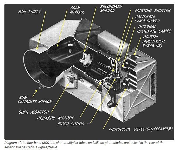
The Multispectral Scanning System
Virginia Tower Norwood decided to quantize the MSS data into 6-bits. Both image data and calibration data (from the onboard internal lamp calibrator) were sent to the ground digitally. Even though the digital MSS data had a small dynamic range (able to show only 64 different radiance values), it could be calibrated, so images could be confidently compared from date-to-date and place-to-place.
The MSS radiometrically-corrected digital data pioneered quantitative satellite remote sensing, taking the science of Earth observation digital, where it has stayed ever since...

50th + Anniversary of Landsat

http://www.greenpolicy360.net/mw/images/Landsat8DataUsersHandbook.pdf
Envisioned as an Intergenerational Science Mission
The first land-focused Earth-observation satellite, Landsat 1 (initially called the 'Earth Resources Technology Satellite-1 / ERTS-1) is launched to Earth orbit from Vandenberg, CA.
Beginnings of Earth Science from Space #RemoteSensing #AtmosphericScience #EarthScience #OceanScience

File history
Click on a date/time to view the file as it appeared at that time.
| Date/Time | Thumbnail | Dimensions | User | Comment | |
|---|---|---|---|---|---|
| current | 18:19, 20 September 2022 | | 688 × 587 (103 KB) | Siterunner (talk | contribs) |
You cannot overwrite this file.
File usage
- Atmosphere
- Atmospheric Science
- Biodiversity
- Citizen Science
- Clean Air
- Clean Water
- Climate Change
- Climate Policy
- Earth
- Earth360
- EarthPOV
- Earth Day
- Earth Imaging
- Earth Observations
- Earth Science
- Earth Science from Space
- Earth System Science
- Eco-nomics
- Ecological Economics
- Ecology Studies
- Environmental Laws
- Environmental Protection
- Environmental Security
- Environmental Security, National Security
- EOS eco Operating System
- Global Security
- Global Warming
- GreenPolicy360
- Green Graphics
- Land Use
- Maps
- NASA
- New Definitions of National Security
- NOAA
- Oceans
- Planet Citizen
- Planet Citizens
- Planet Citizens, Planet Scientists
- Pollution
- Resilience
- Rivers
- Strategic Demands
- Sustainability
- Sustainability Policies
- Toxics and Pollution
- US Environmental Protection Agency
- Water Quality
- Whole Earth