File:Landsat data site.png: Difference between revisions
Siterunner (talk | contribs) No edit summary |
Siterunner (talk | contribs) No edit summary |
||
| (2 intermediate revisions by the same user not shown) | |||
| Line 2: | Line 2: | ||
<big>[[Landsat data users handbook]]</big> | <big>'''[[Landsat data users handbook]]'''</big> | ||
* https://www.usgs.gov/centers/eros/news/eros-50th-history-a-leader-mapping-land-cover-and-change | * https://www.usgs.gov/centers/eros/news/eros-50th-history-a-leader-mapping-land-cover-and-change | ||
* https://www.greenpolicy360.net/w/Landsat_data_users_handbook | |||
| Line 16: | Line 17: | ||
<big><big>'''[[Earth Science Research from Space]] -- [[Earth Imaging-New Space]]'''</big></big> | |||
🌎 | |||
[[File:Earth-NASA.jpg]] | |||
Steve Schmidt/GreenPolicy360 founder: Look back with me to the beginnings of Landsat and Earth Science, digital 'inventories' of our green, living planet that were set in motion with satellite missions that carried forward an original NASA mission statement -- “To understand and protect our home planet..." | |||
Visit our GreenPolicy page dedicated to George E. Brown, the man who was key to the start-up and advancement of Landsat, and a multi-decade constellation of foundational science studying the dynamics of Earth's systems, land, water, life, and our life-enabling atmosphere. | |||
* https://www.greenpolicy360.net/w/George_E._Brown_Jr | |||
* https://www.greenpolicy360.net/w/PlanetCitizen | |||
* https://www.greenpolicy360.net/w/Look_at_how_thin_our_atmosphere_is | |||
* https://www.greenpolicy360.net/w/Earth_Science_Research_from_Space | |||
* https://www.greenpolicy360.net/w/New_Definitions_of_National_Security | |||
[[File:Living Earth.png]] | |||
🌎 | |||
| Line 27: | Line 55: | ||
[[Category:EarthPOV]] | [[Category:EarthPOV]] | ||
[[Category:Earth Art]] | [[Category:Earth Art]] | ||
[[Category:Earth Day]] | |||
[[Category:Earth Observations]] | [[Category:Earth Observations]] | ||
[[Category:Earth Science]] | [[Category:Earth Science]] | ||
[[Category:Earth Science from Space]] | [[Category:Earth Science from Space]] | ||
[[Category:Environmental Protection]] | [[Category:Environmental Protection]] | ||
[[Category:Environmental Security]] | |||
[[Category:Global Security]] | [[Category:Global Security]] | ||
[[Category:GreenPolicy360]] | |||
[[Category:Green Politics]] | [[Category:Green Politics]] | ||
[[Category:Land Use]] | [[Category:Land Use]] | ||
[[Category:NASA]] | [[Category:NASA]] | ||
[[Category:New Definitions of National Security]] | |||
[[Category:New Space]] | [[Category:New Space]] | ||
[[Category:Planet API]] | [[Category:Planet API]] | ||
| Line 41: | Line 73: | ||
[[Category:Space Science and Space Physics]] | [[Category:Space Science and Space Physics]] | ||
[[Category:Whole Earth]] | [[Category:Whole Earth]] | ||
[[Category:Youth]] | |||
[[Category:Alternative Agriculture]] | [[Category:Alternative Agriculture]] | ||
| Line 53: | Line 86: | ||
[[Category:Ecoregions]] | [[Category:Ecoregions]] | ||
[[Category:EOS eco Operating System]] | [[Category:EOS eco Operating System]] | ||
[[Category:Energy]] | |||
[[Category:Farm-Related Policies]] | [[Category:Farm-Related Policies]] | ||
[[Category:Food]] | [[Category:Food]] | ||
[[Category:Food-Related Policies]] | [[Category:Food-Related Policies]] | ||
[[Category:Global Security]] | [[Category:Global Security]] | ||
[[Category:Global Warming]] | |||
[[Category:Green Best Practices]] | [[Category:Green Best Practices]] | ||
[[Category:Green Graphics]] | [[Category:Green Graphics]] | ||
| Line 62: | Line 97: | ||
[[Category:Land Ethic]] | [[Category:Land Ethic]] | ||
[[Category:Permaculture]] | [[Category:Permaculture]] | ||
[[Category:Renewable Energy]] | |||
[[Category:Resilience]] | [[Category:Resilience]] | ||
[[Category:Sea-level Rise]] | [[Category:Sea-level Rise]] | ||
Latest revision as of 15:22, 10 November 2023
- https://www.usgs.gov/centers/eros/news/eros-50th-history-a-leader-mapping-land-cover-and-change
- https://www.greenpolicy360.net/w/Landsat_data_users_handbook
First, a Map of the Entire U.S.—and Then the World
The USGS Earth Resources Observation and Science (EROS) Center, celebrating its 50th anniversary this year, was developed at the beginning of the Landsat Earth observation satellite program as a place to store and distribute the imagery. Through the years, EROS has become much more—including a place to advance land cover mapping and monitoring through an unbiased scientific lens...
In the 1980s, as EROS began its International Program, a different type of satellite data factored in. TheAdvanced Very High Resolution Radiometer (AVHRR) sensor aboard National Oceanic and Atmospheric Administration (NOAA) meteorological satellites could cover the entire Earth in one day at a coarse scale and reveal information about vegetation cover and conditions.
Examples of applications of the global database included the World Resource Institute Global Watersheds Vulnerability Assessment, the United Nations Food and Agriculture Organization Global Forest Resources Assessment and the National Geographic Society Satellite Atlas of the World.
Earth Science Research from Space -- Earth Imaging-New Space
🌎

Steve Schmidt/GreenPolicy360 founder: Look back with me to the beginnings of Landsat and Earth Science, digital 'inventories' of our green, living planet that were set in motion with satellite missions that carried forward an original NASA mission statement -- “To understand and protect our home planet..."
Visit our GreenPolicy page dedicated to George E. Brown, the man who was key to the start-up and advancement of Landsat, and a multi-decade constellation of foundational science studying the dynamics of Earth's systems, land, water, life, and our life-enabling atmosphere.
- https://www.greenpolicy360.net/w/George_E._Brown_Jr
- https://www.greenpolicy360.net/w/PlanetCitizen
- https://www.greenpolicy360.net/w/Look_at_how_thin_our_atmosphere_is
- https://www.greenpolicy360.net/w/Earth_Science_Research_from_Space
- https://www.greenpolicy360.net/w/New_Definitions_of_National_Security

🌎
File history
Click on a date/time to view the file as it appeared at that time.
| Date/Time | Thumbnail | Dimensions | User | Comment | |
|---|---|---|---|---|---|
| current | 12:37, 17 September 2023 | 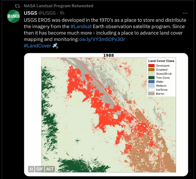 | 657 × 600 (499 KB) | Siterunner (talk | contribs) |
You cannot overwrite this file.
File usage
The following 2 pages use this file:
- Maps
- Agricultural Economics
- Agriculture
- Democratization of Space
- Earth360
- EarthPOV
- Earth Art
- Earth Day
- Earth Observations
- Earth Science
- Earth Science from Space
- Environmental Protection
- Environmental Security
- Global Security
- GreenPolicy360
- Green Politics
- Land Use
- NASA
- New Definitions of National Security
- New Space
- Planet API
- Planet Citizen
- Planet Citizens, Planet Scientists
- Space Science and Space Physics
- Whole Earth
- Youth
- Alternative Agriculture
- Aquifers
- Appropriate Technology
- Biodiversity
- Bioneers
- Biogeosciences
- Bioregionalism
- Eco-nomics
- Ecology Studies
- Ecoregions
- EOS eco Operating System
- Energy
- Farm-Related Policies
- Food
- Food-Related Policies
- Global Warming
- Green Best Practices
- Green Graphics
- Land Ethic
- Permaculture
- Renewable Energy
- Resilience
- Sea-level Rise
- Soil
- Strategic Demands
- Sustainability
- Sustainability Policies
- Water
- Watersheds
- Wetlands
- Atmospheric Science
- Climate Change
- Climate Policy
- Planetary Science