File:Landsat at AT.png
Landsat_at_AT.png (762 × 598 pixels, file size: 972 KB, MIME type: image/png)
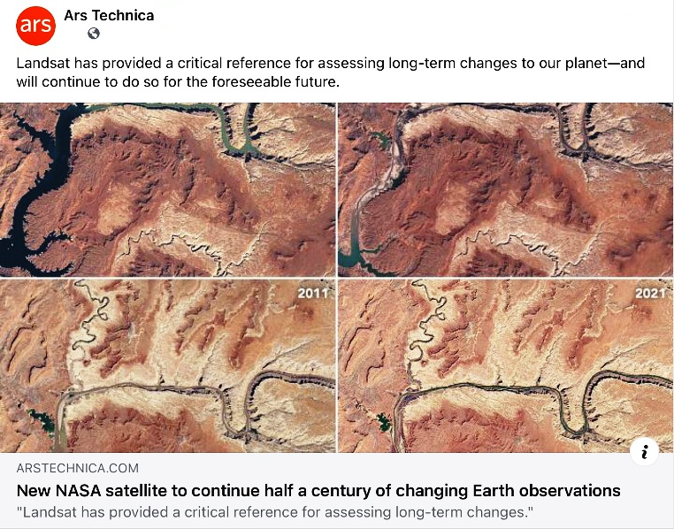
Lake Powell 1999-2020
Changing planet
New NASA satellite to continue half a century of changing Earth observations
"Landsat has provided a critical reference for assessing long-term changes."
Via Ars Technica
We now have a nearly half-century-long record of changes to the planet's surface—from farms and forests to glaciers and urban areas... "Landsat has provided a critical reference for assessing long-term changes to Earth's land environment due to both natural and human forcing."
Landsat 9: Empowering open science and applications through continuity
Highlights
• The Landsat 9 mission will continue, and improve on, the capabilities of Landsat 8.
• Performance of OLI-2 and TIRS-2 instruments appears to be excellent.
• USGS will provide standard surface reflectance and temperature products.
• Surface temperature will initially be derived via single-channel algorithm.
The history of Earth observation from space is well reflected through the Landsat program. With data collection beginning with Landsat-1 in 1972, the program has evolved technical capabilities while maintaining continuity of land observations. In so doing, Landsat has provided a critical reference for assessing long-term changes to Earth's land environment due to both natural and human forcing. Poised for launch in mid-2021, the joint NASA-USGS Landsat 9 mission will continue this important data record. In many respects Landsat 9 is a clone of Landsat-8. The Operational Land Imager-2 (OLI-2) is largely identical to Landsat 8 OLI, providing calibrated imagery covering the solar reflected wavelengths. The Thermal Infrared Sensor-2 (TIRS-2) improves upon Landsat 8 TIRS, addressing known issues including stray light incursion and a malfunction of the instrument scene select mirror. In addition, Landsat 9 adds redundancy to TIRS-2, thus upgrading the instrument to a 5-year design life commensurate with other elements of the mission. Initial performance testing of OLI-2 and TIRS-2 indicate that the instruments are of excellent quality and expected to match or improve on Landsat 8 data quality. Landsat-9 will maintain the current data acquisition rate of up to 740 scenes per day, with these scenes available from the Landsat archive at no cost to users. In this communication, we provide background and rationale for the Landsat 9 mission, describe the instrument payloads and ground system, and discuss data products available from the Landsat 9 mission through USGS.
🌎
File history
Click on a date/time to view the file as it appeared at that time.
| Date/Time | Thumbnail | Dimensions | User | Comment | |
|---|---|---|---|---|---|
| current | 14:02, 11 October 2021 | | 762 × 598 (972 KB) | Siterunner (talk | contribs) |
You cannot overwrite this file.
File usage
The following page uses this file:
- Anthropocene
- Atmospheric Science
- Citizen Science
- Climate Change
- Climate Policy
- Democratization of Space
- Earth360
- Earth Imaging
- Earth Observations
- Earth Science
- Eco-nomics
- Environmental Full-cost Accounting
- Environmental Laws
- Environmental Protection
- Environmental Security
- Environmental Security, National Security
- ESA
- Externalities
- Fossil Fuels
- Global Security
- Global Warming
- Green Graphics
- Money in Politics
- NASA
- NOAA
- Natural Resources
- New Definitions of National Security
- New Space
- Orbital Perspective
- Planet Citizen
- Planet Citizens
- Planet Scientist
- Planet Citizens, Planet Scientists
- Planetary Science
- Sea-Level Rise & Mitigation
- Space Science and Space Physics
- Strategic Demands
- ThinBlueLayer
- Threat Multiplier
- US Environmental Protection Agency
- Whole Earth