File:DSCOVR w EPICcam.png: Difference between revisions
Siterunner (talk | contribs) No edit summary |
Siterunner (talk | contribs) No edit summary |
||
| (14 intermediate revisions by the same user not shown) | |||
| Line 1: | Line 1: | ||
<addthis /> | |||
<big><big>'''The DSCOVR Deep-Space Mission'''</big></big> | |||
'''February 12, 2015 / DSCOVR-EPIC Is Launched with SpaceX''' | |||
GreenPolicy360 assists NASA's mission team | |||
We/GreenPolicy360 are cooperating with NASA DSCOVR mission managers and will be delivering a stream of home planet imagery and data as NASA/NOAA begin uploading EPIC-cam and instrument 'pictures of home'! | |||
[[Planet Citizens, Planet Scientists]] | |||
The DSCOVR satellite with its EPIC cam, PlasMag & NISTAR instrument package is on the way... a million miles toward the Sun then 'parked' in orbit to send data of our Earth to us everyday on Earth, including the first Whole Earth photos taken since 1972. | |||
<big><big>'''DSCOVR with EPIC Cam'''</big></big> | |||
<small>''Sometimes it is worth stepping back and simply admiring Earth. It is a beautiful, awe-inspiring place, and it is the only world most of us will ever know. Of all celestial bodies within reach or view, as far as we can see, out to the edge, the most wonderful and marvelous and mysterious is turning out to be our own planet earth. There is nothing to match it anywhere, not yet anyway. — Lewis Thomas'' </small> | |||
The Earth science data will be processed at NASA’s DSCOVR Science Operations Center and archived and distributed by NASA’s Atmospheric Science Data Center. | |||
Earth Polychromatic Imaging Camera (EPIC) | |||
• http://www.nasa.gov/content/goddard/noaas-dscovr-to-provide-epic-views-of-earth/ | |||
• http://www.nesdis.noaa.gov/DSCOVR/pdf/DSCOVR%20-%20EPIC%20Instrument%20Info%20Sheet.pdf | |||
• http://www.nesdis.noaa.gov/DSCOVR/ | |||
• http://mediaarchive.ksc.nasa.gov/search.cfm?cat=278%C2%A0%C2%A0%C2%A0 | |||
| |||
<small>http://www.greenpolicy360.net/w/File:EPIC_cam.jpg</small> | |||
[[File:EPIC cam.jpg]] | |||
=='''[[EarthPOV]]'''== | |||
'''For GreenPolicy360, the centerpiece of the mission will be the EPIC cam images of Earth 360''' | |||
First whole earth pictures to be delivered from deep space [https://www.greenpolicy360.net/w/File:Blue_Marble_photo_-_Apollo_17.jpg since 1972] -- images we are looking to share as a life message of our home planet | |||
'''Planet Citizens we are -- together''' | |||
| |||
:<big>''[[Earth Science Research from Space]]''</big> | |||
:<big>''[[Earth and Space, Politics]]''</big> | |||
:<big>''[[Climate News]]''</big> | |||
:<big>''[[OCO-2]]''</big> | |||
:<big>''[[HelloEarth]]''</big> | |||
:<big>''[[Earth Right Now]]''</big> | |||
:<big>''[[Earth Science Vital Signs]]''</big> | |||
| |||
::::::::[https://www.greenpolicy360.net/w/File:DSCOVR_looks_back_at_earth_from_a_million_miles_away_m.jpg <big><big><big>'''''NASA's DSCOVR Mission'''''</big></big></big>] | |||
::::::::<big><big>'''''GreenPolicy360's in on the Mission'''''</big></big> | |||
'''''GreenPolicy360 stepped up as [http://www.planetcitizen.org Planet Citizens] to assist the NASA/NOAA team to deliver the first DSCOVR/EPIC data and imagery''''' | |||
''[http://www.greenpolicy360.net/w/Category:NASA '''NASA's'''] [https://www.greenpolicy360.net/w/File:DSCOVR_looks_back_at_earth_from_a_million_miles_away_m.jpg '''DSCOVR/EPIC'''] website of Earth images is now being made available online daily...'' | |||
''Unprecedented accompanying data and imagery made available open source for #EarthScience and climate/atmospheric monitoring.'' | |||
''NASA Goddard communications to us, including this March 11th correspondence with GreenPolicy360, discussed calibrated data products to come from DSCOVR...'' | |||
''The individual 10 different wavelength EPIC data will be (and is now being) served from the [https://eosweb.larc.nasa.gov Atmospheric Science Data Center (ASDC) at Langley.]'' | |||
:[[File:DSCOVR-2015-First Set of Images-test.png]] | |||
| |||
<big><big><big>'''Welcome to Daily Views of Our Home Planet'''</big></big></big> | |||
[https://www.greenpolicy360.net/w/File:DSCOVR_w_EPICcam,_PlasMag_%26_NISTAR.png ''The DSCOVR satellite with its EPIC cam, PlasMag & NISTAR instrument package]... is on a million mile journey and in approx four months, DSCOVR will "light up", be tested, and begin delivering data to Earth. In its historic mission, DSCOVR and its EPIC imaging system will begin sending near real-time images of the whole Earth... it has been many years since whole Earth images have been readily available...'' | |||
[http://www.nasa.gov/press-release/nasa-satellite-camera-provides-epic-view-of-earth <big><big>'''DSCOVR 'Selfies' '''</big></big>] | |||
::• ''http://www.nesdis.noaa.gov/DSCOVR/'' | |||
::• ''http://epic.gsfc.nasa.gov/'' | |||
················································ | |||
[http://www.greenpolicy360.net/w/File:DSCOVR-EPIC_187_1003705_americas_dxm.png <big><big>'''The Ultimate "Big Picture"'''</big></big>] | |||
::[http://www.nasa.gov/press-release/daily-views-of-earth-available-on-new-nasa-website/ '''''DSCOVR/EPIC News'''''] | |||
················································ | |||
<big><big>'''"Blue Marble"'''</big></big> | |||
'''In Memory of the Apollo 17 1972 Image of Our Home Planet''' | |||
* [http://www.greenpolicy360.net/w/Earthviews '''''Earthviews'''''] — [http://www.nasa.gov/content/celebrating-earths-beauty'''''Celebrating Earth's Beauty'''''] | |||
| |||
[[File:Blue Marble photo - Apollo 17.jpg]] | |||
[https://www.greenpolicy360.net/w/File:Earth-NASA.jpg <big><big><big>'''Earth'''</big></big></big>] | |||
[[File:Earth-NASA.jpg]] | |||
○ | |||
[[Category:Atmospheric Science]] | |||
[[Category:Climate Policy]] | |||
[[Category:Democratization of Space]] | |||
[[Category:Earth360]] | |||
[[Category:Earth Imaging]] | |||
[[Category:Earth Observations]] | |||
[[Category:Earth Science]] | |||
[[Category:Ecology Studies]] | |||
[[Category:Environmental Security]] | |||
[[Category:EOS eco Operating System]] | |||
[[Category:Green Graphics]] | |||
[[Category:NASA]] | |||
[[Category:New Definitions of National Security]] | |||
[[Category:New Space]] | |||
[[Category:Online Education]] | |||
[[Category:Planet Citizen]] | |||
[[Category:Planet Citizens]] | |||
[[Category:Planet Citizens, Planet Scientists]] | |||
[[Category:Strategic Demands]] | |||
[[Category:Whole Earth]] | |||
[[Category:Climate Change]] | |||
[[Category:Cryosphere]] | |||
[[Category:Geophysics and Geochemistry]] | |||
[[Category:Mineralogy]] | |||
[[Category:Geology]] | |||
[[Category:Geophysics]] | |||
[[Category:Hydrology]] | |||
[[Category:Natural Resources]] | |||
[[Category:Ocean Science]] | |||
[[Category:Planetary Science]] | |||
[[Category:Space Science and Space Physics]] | |||
Latest revision as of 18:36, 26 March 2020
<addthis />
The DSCOVR Deep-Space Mission
February 12, 2015 / DSCOVR-EPIC Is Launched with SpaceX
GreenPolicy360 assists NASA's mission team
We/GreenPolicy360 are cooperating with NASA DSCOVR mission managers and will be delivering a stream of home planet imagery and data as NASA/NOAA begin uploading EPIC-cam and instrument 'pictures of home'!
Planet Citizens, Planet Scientists
The DSCOVR satellite with its EPIC cam, PlasMag & NISTAR instrument package is on the way... a million miles toward the Sun then 'parked' in orbit to send data of our Earth to us everyday on Earth, including the first Whole Earth photos taken since 1972.
DSCOVR with EPIC Cam
Sometimes it is worth stepping back and simply admiring Earth. It is a beautiful, awe-inspiring place, and it is the only world most of us will ever know. Of all celestial bodies within reach or view, as far as we can see, out to the edge, the most wonderful and marvelous and mysterious is turning out to be our own planet earth. There is nothing to match it anywhere, not yet anyway. — Lewis Thomas
The Earth science data will be processed at NASA’s DSCOVR Science Operations Center and archived and distributed by NASA’s Atmospheric Science Data Center.
Earth Polychromatic Imaging Camera (EPIC)
• http://www.nasa.gov/content/goddard/noaas-dscovr-to-provide-epic-views-of-earth/
• http://www.nesdis.noaa.gov/DSCOVR/pdf/DSCOVR%20-%20EPIC%20Instrument%20Info%20Sheet.pdf
• http://www.nesdis.noaa.gov/DSCOVR/
• http://mediaarchive.ksc.nasa.gov/search.cfm?cat=278%C2%A0%C2%A0%C2%A0
http://www.greenpolicy360.net/w/File:EPIC_cam.jpg

EarthPOV
For GreenPolicy360, the centerpiece of the mission will be the EPIC cam images of Earth 360
First whole earth pictures to be delivered from deep space since 1972 -- images we are looking to share as a life message of our home planet
Planet Citizens we are -- together
- GreenPolicy360's in on the Mission
GreenPolicy360 stepped up as Planet Citizens to assist the NASA/NOAA team to deliver the first DSCOVR/EPIC data and imagery
NASA's DSCOVR/EPIC website of Earth images is now being made available online daily...
Unprecedented accompanying data and imagery made available open source for #EarthScience and climate/atmospheric monitoring.
NASA Goddard communications to us, including this March 11th correspondence with GreenPolicy360, discussed calibrated data products to come from DSCOVR...
The individual 10 different wavelength EPIC data will be (and is now being) served from the Atmospheric Science Data Center (ASDC) at Langley.

Welcome to Daily Views of Our Home Planet
The DSCOVR satellite with its EPIC cam, PlasMag & NISTAR instrument package... is on a million mile journey and in approx four months, DSCOVR will "light up", be tested, and begin delivering data to Earth. In its historic mission, DSCOVR and its EPIC imaging system will begin sending near real-time images of the whole Earth... it has been many years since whole Earth images have been readily available...
················································
················································
"Blue Marble"
In Memory of the Apollo 17 1972 Image of Our Home Planet


○
File history
Click on a date/time to view the file as it appeared at that time.
| Date/Time | Thumbnail | Dimensions | User | Comment | |
|---|---|---|---|---|---|
| current | 14:06, 20 March 2020 | 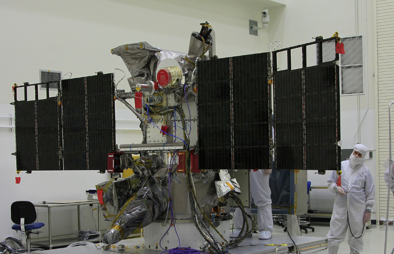 | 800 × 515 (968 KB) | Siterunner (talk | contribs) |
You cannot overwrite this file.
File usage
The following page uses this file:
- Atmospheric Science
- Climate Policy
- Democratization of Space
- Earth360
- Earth Imaging
- Earth Observations
- Earth Science
- Ecology Studies
- Environmental Security
- EOS eco Operating System
- Green Graphics
- NASA
- New Definitions of National Security
- New Space
- Online Education
- Planet Citizen
- Planet Citizens
- Planet Citizens, Planet Scientists
- Strategic Demands
- Whole Earth
- Climate Change
- Cryosphere
- Geophysics and Geochemistry
- Mineralogy
- Geology
- Geophysics
- Hydrology
- Natural Resources
- Ocean Science
- Planetary Science
- Space Science and Space Physics