Category:Sea-level Rise
<addthis />

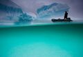
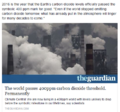
Denial Problem?

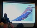
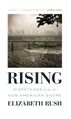
by Isaac Cordel
○
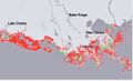
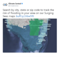
Take a Closer Look at Florida in the U.S.
- The Terrestrial Home Base of GreenPolicy360

○
At Ground Zero for Rising Seas, TV Weatherman Talks Climate

○
Florida, a Limestone Peninsula" Who Cares About Karst?
The Florida Peninsula is a limestone plateau formed many millions of years ago when the area was a warm, shallow sea. Millions of years of deposits from small sea creatures make up the limestone, which is several thousand feet thick.
The Karst formation, caves, tunnels, underground springs, porous geology adding impact to sea-level rise and salt water intrusion...
Re: Florida topography:
What we see of Florida is just part of an enormous carbonate platform that developed over millions of years. When the bit of metamorphic rock that would become Florida's basement rifted off of proto-Africa in the time of Pangea, a basin formed as the baby Atlantic Ocean was born. That's where the Florida Platform began to form: in shallow, warm seas filled with coral reefs and algae with calcium carbonate skeletons, living happily under the sun, producing those calcium carbonate bits that built up incrementally as they died. And this went on for ages, right up through the Paleogene, the geologic age after the death of the dinosaurs. There are cliffs bounding the Florida Platform that are nearly 1,828 meters (6,000 feet) high, beneath the waters of the Gulf of Mexico. That immense carbonate mass may be more than 6,096 meters (20,000 feet) deep. That's a huge amount of potential karst. (From Scientific American)
Thick carbonate deposits under most of Florida comprise the Floridan aquifer system... The high productivity of this aquifer is due to the development of secondary porosity caused by dissolution or karst processes.
Karst topography is the geological name given to an area of limestone bedrock featuring caves, sinkholes, underground streams and natural springs (Florida has one of the highest concentrations of springs on Earth). In laymen terms, karst topography is anywhere the lower levels of the soil horizon has been dissolved by the physical or chemical weathering of the bedrock. These environments are comprised of carbonate rocks, such as dolomite and limestone, or having high amounts of evaporites, for example, salt and gypsum, as these materials tend to be highly soluble in water. Having these conditions within humid climate like Florida invites faster weathering. Another erosion accelerator is groundwater mixed with vegetation creates a weak acid that dissolves the limestone. (think baking soda mixing with vinegar) Over time, cracks become caves, and when caves collapse they form exposed openings known as karst windows.
Karst processes characteristically develop zones of enhanced porosity within carbonate rocks creating a highly heterogeneous aquifer system with rapid rates of ground-water movement and recharge. Subsidence events caused by the collapse of materials into overlying caverns and caves can result in structural damage at land surface. More importantly karst-related features can create direct pathways for introducing surface contaminants into the ground-water system where remediation is difficult.
USGS / United States Geological Survey: Groundwater contamination is the most significant problem in karst. The formation of solution channels and sinkholes create a direct avenue for the movement of inadequately treated stormwater and wastewater into the aquifer. In karst aquifers, turbulently flowing underground streams have velocities approaching those of surface streams. The nature of the groundwater flow system causes karst areas to be extremely vulnerable to groundwater contamination.
Most of Florida is prone to karst-related water-resource problems...
○
Rising seas/climate change will have a special impact on FL due to the underground systems
- Saltwater intrusion and groundwater contamination will be and already is a critical issue in the region's future.....

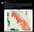
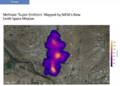
https://blogs.scientificamerican.com/rosetta-stones/files/2013/03/Sinkhole-zones-in-fl.jpg

- ○ ○ ○ ○ ○ ○ ○ ○ ○ ○ ○ ○ ○ ○ ○ ○ ○ ○ ○ ○ ○ ○ ○ ○ ○ ○ ○ ○ ○ ○
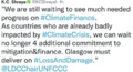
Banned in Florida: Government Frowns on the Use of the Term -- "Climate Change"
- Political Denial of Climate Impacts
- Sea Rise, Flooding, Underground Contamination of Fresh Water
- Statewide Community Impact... Economic Disruption, Cost and Economic Loss
Can't Happen Here, Not Happening Here, Don't Wanna Here About It

https://in.reuters.com/article/2015/03/09/us-usa-florida-climatechange-idINKBN0M51P520150309
https://www.miamiherald.com/news/state/florida/article12983720.html
https://mashable.com/2015/03/09/florida-bans-global-warming/
https://qz.com/358675/floridas-authorities-want-to-wish-climate-change-away/
https://www.motherjones.com/blue-marble/2015/03/florida-climate-change
https://www.salon.com/2015/03/09/the_term_climate_change_is_reportedly_banned_in_florida/
https://www.engadget.com/2015/03/09/rick-scott-climate-change-denial-in-florida/
https://www.theguardian.com/us-news/2015/mar/08/florida-banned-terms-climate-change-global-warming
https://www.cnn.com/2015/03/09/politics/florida-officials-climate-change-banned/
○

○
Florida International University Researchers Tackle Sea Level Rise
Rising seas in South Florida, PBS-2014 - South Florida Rising Seas - PBS
○
Big Energy companies in Florida look to "gut energy savings goals"
In Florida, fossil fuel energy co's have their way in a pro-fossil fueled legis and w/ the gov. Today we read the energy co's are officially against renewables, incl solar in the "Sunshine State", claiming to the PSC that energy 'savings' are bad (for them) and then there's the 'if they can't grow, they'll die' argument (so pay more, use more, pollute more, greenhouse more, sea rise more, not to worry, bigger better, more better.) What's wrong w/ this picture?
○
Scientists petition the governor
Southeast Florida Climate Compact
Resiliency against sea-level rise
NASA study of Southeast Florida Vulnerability to Sea-Level Rise
Florida and the Surging Seas, a Vulnerability Assessment
South Florida Faces Ominous Prospects from Rising Waters / NYT
Rising Seas: South Florida, Inching toward Disaster
Florida - Impact of Sea Level Rise on Energy and Water
○
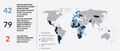
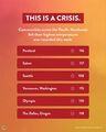
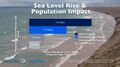
A 2014 report released by the research and journalism group Climate Central found that 2,120 square miles of land lie less than 3 feet above the high tide line in Florida. That means 300,000 homes, or around $145 billion in property value, are at risk.... Climate Central found that $71 billion of Florida property sits on land less than two feet above the high tide line.
Florida (sea-level mapping)
Sea-rise near-, mid-, long-term projections


[2]]

Rising Seas_Art


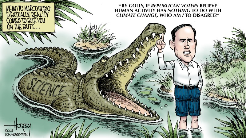
In Denial, Not a River
Senator Marco Rubio (Republican-FLA) on Climate Change
Marco Rubio ... Deny, deny, deny
○
Subcategories
This category has the following 9 subcategories, out of 9 total.
A
C
E
F
G
W
Pages in category "Sea-level Rise"
The following 36 pages are in this category, out of 36 total.
C
D
E
G
Media in category "Sea-level Rise"
The following 200 files are in this category, out of 582 total.
(previous page) (next page) Jerry Brown-Climate Week, NYC, Sept2018.jpg 800 × 534; 242 KB
 Jerry Brown-Global Climate Action Summit.png 800 × 453; 900 KB
 Jerry-Brown-quote.jpg 800 × 552; 69 KB
 John Kerry - Climate Envoy - 2021-09-26.png 640 × 410; 349 KB
 Journey of a Climate Pixel - May 2022.png 800 × 399; 114 KB
 June 2019 - NASA GISS data - hottest on record.jpg 640 × 560; 58 KB
 Kamala Harris-GND-Jan 28,2019.png 679 × 609; 243 KB
 Katharine Hayhoe - Nov 26, 2019.jpg 508 × 466; 80 KB
 Kathy-castor-tampa-bay-florida.jpg 750 × 600; 41 KB
 Kim Cobb - Georgia Tech professor of climate science.jpeg 800 × 533; 87 KB
 LA Times - July 2023 on the world's response to the climate crisis-1a.png 800 × 1,011; 657 KB
 LA Times on the world's response to the climate crisis-2.png 800 × 651; 297 KB
 LA Times on the world's response to the climate crisis-3.png 800 × 806; 302 KB
 LA Times on the world's response to the climate crisis-4.png 800 × 896; 321 KB
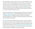
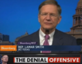
 Lamar accuses March 2017.png 800 × 439; 245 KB
 Lamar re science and Trumps truth.png 627 × 607; 206 KB
 Lamar Smith Denial Offensive.png 393 × 307; 224 KB
 Lamar's science.png 584 × 537; 204 KB
 Land Remote Sensing Policy Act of 1992.jpg 563 × 480; 144 KB
 Landsat 50th anniv Sept 2016.jpg 800 × 456; 94 KB
 Landsat at 50.png 800 × 713; 345 KB
 Landsat data site.png 657 × 600; 499 KB
 Landsat NASA - Feb 11 2023.png 763 × 600; 578 KB
 Landsat US collection of maps 1985-2021.png 768 × 775; 1,018 KB
 Launch complex 34, Cape Canaveral.jpg 800 × 363; 31 KB
 Launching soon.png 657 × 468; 225 KB
 LDCs face the climate crisis, raise the alarm - Nov 2021.png 419 × 226; 126 KB
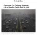 Like a speeding freight train.png 640 × 600; 492 KB
 Living Shoreline - St Pete Beach - July 2020.jpg 600 × 800; 221 KB
 Living-Shoreline.png 800 × 367; 128 KB
 LivingShorelines Graph.png 680 × 375; 73 KB
 LMDCs make their case at the Glasgow climate summit.png 427 × 480; 259 KB
 Louisiana sea level rise risks.jpg 600 × 364; 54 KB
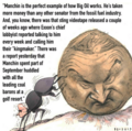
 Manchin kills the Biden climate plan.jpg 800 × 438; 71 KB
 Manchin News - Dec 20 2021.png 600 × 588; 307 KB
 Manchin News 2 - Dec 20 2021.png 600 × 600; 329 KB
 Mangroves 'green wall' in China.png 600 × 600; 466 KB
 Mangroves and Coastal Wetlands tracked by Landsat.png 600 × 716; 245 KB
 Mangroves regulate flooding - EDF.png 568 × 473; 328 KB
 Mapping changes in global temperature 1850-2022.png 656 × 680; 180 KB
 Mar a lagoon tba.jpg 540 × 405; 40 KB
 Mascot for Glasgow intl climate conference.jpg 575 × 396; 76 KB
 Master Plan by Chad Wright.jpg 1,320 × 354; 90 KB
 Master Plan-by-Chad-Wright-b.jpg 600 × 439; 59 KB
 Master-Plan-by-Chad-Wright c.jpg 784 × 560; 113 KB
 Master-Plan-Chad-Wright-a.jpg 570 × 570; 102 KB
 Master-Plan-Chad-Wright-d.jpg 1,024 × 1,024; 1.05 MB
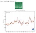
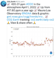 Mauna Loa CO2 - April 2022.png 600 × 618; 203 KB
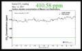 Mauna Loa CO2 week ending May 15, 2017.png 800 × 493; 77 KB
 Mauna Loa Observatory CO2 - April 2021 - New record high.jpg 656 × 600; 55 KB
 Maya Lin Ghost Forest 5-17-2021.jpg 618 × 454; 123 KB
 McKibben 350.org logo.jpg 300 × 170; 7 KB
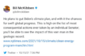
 McKibben re Manchin - Dec 2021.png 370 × 368; 261 KB
 McKibben reaction to Manchin blocking Biden's climate plan.png 640 × 423; 140 KB
 Message to-marco-rubio-on-climate.jpg 800 × 450; 191 KB
 Methane cuts pledge - COP27.png 399 × 336; 164 KB
 Methane emissions to be cut - COP26 pledges.png 640 × 464; 140 KB
 Methane Reduction proposal passes in EU Parliament - May 2023.png 620 × 600; 552 KB
 MethaneSat - 1.jpg 350 × 336; 58 KB
 MethaneSat - 2.PNG 448 × 336; 172 KB
 MethaneSat - 3.PNG 448 × 303; 248 KB
 Methods to enforce climate pledges-NDCs - Dec 2021.png 539 × 480; 333 KB
 Miami Dem debate - NBCs Savannah on scene.jpg 600 × 600; 105 KB
 Miami Reminder.jpg 411 × 292; 52 KB
 Miami sea level rise conf-May2018.jpg 800 × 600; 53 KB
 Miami-beach-waterworld-david-kamp.jpg 900 × 651; 222 KB
 Michael E Mann -- act with hope not fear.jpg 720 × 1,024; 122 KB
 Michael E Mann, act with hope not fear.jpg 1,246 × 1,772; 256 KB
 Michael Mann - Susan Joy Hassol after Glasgow.jpg 460 × 1,616; 299 KB
 Mick stands in support of the global climate strike.jpg 587 × 710; 123 KB
 Money in Politics - PoliticoPay.png 491 × 226; 31 KB
 Monitoring Greenhouse Gases from Satellite Missions 2021-2030.png 801 × 386; 143 KB
 Montana climate trial News - 2023-08-14.png 789 × 768; 389 KB
 Montreal Protocol - effects study 2021.jpg 640 × 401; 76 KB
 Move along Florida-May 2018.png 448 × 454; 342 KB
 Moving to Higher Ground.png 568 × 473; 307 KB
 Mulvaney says no lifestyle change.jpg 561 × 779; 128 KB
 NASA Climate Feb16,2017.png 593 × 526; 348 KB
 NASA co2-graph-061219.jpg 800 × 500; 214 KB
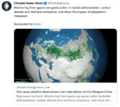
 NASA has a new mission... against Methane.png 800 × 576; 681 KB
 NASA orbiting fleet 2015 m.jpg 690 × 518; 234 KB
 National Climate Pledges Must Be Enforced.png 800 × 520; 122 KB
 National Climate Task Force - first mtg Feb 11 2021.jpg 591 × 654; 144 KB
 NationalGeographic SouthPole melt West Antarctica 2016.jpg 630 × 438; 89 KB
 NDC Tracker - 2020.jpg 800 × 340; 50 KB
 New Climate Maps for US - 2020.jpg 800 × 169; 34 KB
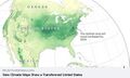 New Climate Maps for US.jpg 677 × 405; 47 KB
 New Climate Model.jpg 777 × 412; 70 KB
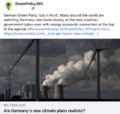 New German government announces far reaching climate plans.png 632 × 600; 446 KB
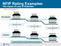 NFIP-Rates with and without subsidies.jpg 480 × 360; 40 KB
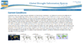 NIDIS Global Drought Conditions June 2016 Report .png 800 × 423; 214 KB
 NOAA - NCEI report on US temps 2023-2024.jpg 600 × 561; 109 KB
 NOAA Climate.Gov.png 589 × 99; 7 KB
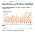
 NOAA data Temp Jan-Dec 2015.gif 990 × 765; 167 KB
 NOAA extreme weather events charting.png 663 × 600; 288 KB
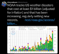
 NOAA report on heat records broken in US - 2023.jpg 600 × 480; 229 KB
 NOAA undergoes political changes - Oct 2020.jpg 800 × 719; 135 KB
 Nobel Prize 2021.jpg 551 × 473; 212 KB
 North America West Coast hot - Aug 2023.png 484 × 501; 308 KB
 Not to worry 2016.png 539 × 401; 347 KB
 NY Times - Nov 24, 2018.jpg 348 × 640; 56 KB
 NYT - Nov 1 - Day 1 headlines from Glasgow Climate Summit.png 600 × 800; 103 KB
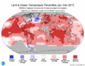
 Ocean temps 20013-2012 NASA.png 360 × 745; 247 KB
 Oceans and Climate Change - DeCaprio July 2022.png 600 × 689; 677 KB
 Oceans heat added 1955-2011 lawrencelivermorelab 2016.jpg 477 × 480; 30 KB
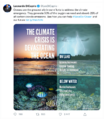
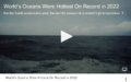 Oceans hottest in 2022.png 800 × 501; 358 KB
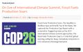 Oct 21, 2021 - On Eve of International Climate Summit.jpg 733 × 466; 119 KB
 October 2016-400PPM.png 494 × 463; 160 KB
 Octopus, canary in Miami.jpg 800 × 600; 55 KB
 OhClarence - Google News - Aug 10, 2023.png 800 × 856; 391 KB
 OhClarence 2 - Google News - Aug 10, 2023.png 800 × 819; 461 KB
 OhClarence 3 - Google News - Aug 10, 2023.png 800 × 842; 473 KB
 OhClarence 4- Google News - Aug 10, 2023.png 800 × 853; 491 KB
 Oil gas climate change response plans - circa 2022.png 729 × 837; 335 KB
 Oil production-global 2020.JPG 640 × 478; 56 KB
 Oil profits and US gas prices.png 378 × 336; 163 KB
 Our Biggest Experiment - by Alice Bell.jpg 333 × 499; 40 KB
 Our Fragile Moment.jpg 612 × 480; 80 KB
 Our Fragile Moment.png 301 × 448; 360 KB
 Ovink 3a.jpg 800 × 600; 89 KB
 Pacific Northwest-US-Too Hot-June 2021.jpg 336 × 420; 21 KB
 Paleoclimate-at the Museum of Natural History-2.png 800 × 449; 418 KB
 Paris 1.5.jpg 620 × 387; 189 KB
 Paris toward 100 percent renewable energy.jpg 620 × 416; 80 KB
 PBS NOVA on climate change resiliency.jpg 497 × 679; 122 KB
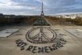
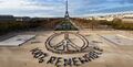 Peace-at-eiffel-tower l.jpg 2,632 × 1,345; 420 KB
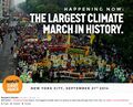 People Climate March Sept. 21st Sunday afternoon.jpg 890 × 717; 244 KB
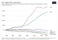 Per capita CO2 emissions - to 2020.png 640 × 442; 153 KB
 Picturing Earth from the International Space Station.jpg 800 × 470; 112 KB
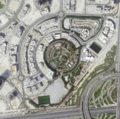 Planet Dove satellite image over Dubai.png 800 × 791; 1.58 MB
 Planet Plan B - for Senator Manchin.jpg 640 × 361; 89 KB
 Polar Sea - Netflix.jpg 459 × 761; 120 KB
 Politics and Science in the House un-Science Committee.png 619 × 352; 198 KB
 Pope meeting with oil execs - June 2019.png 640 × 360; 589 KB
 Price Reduced.png 640 × 292; 341 KB
 Production Gap - productiongap.org.png 600 × 762; 225 KB
 Production Gap - UN report on fossil fuel production.png 600 × 664; 342 KB
 Pruitt in the news daily.png 550 × 541; 148 KB
 Race to Zero - circa January 2022.png 480 × 591; 138 KB
 RacetoZero - Dec 2020 UNFCCC.jpg 585 × 518; 95 KB
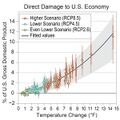 RCP-projections-damage to US economy.jpg 600 × 600; 62 KB
 Record tumble - climate change.png 727 × 333; 27 KB
 Red Line PPM.png 800 × 486; 163 KB
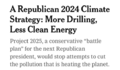 Republican Party 2024 Climate Strategy.png 589 × 344; 44 KB
 Revkin-Brown re AGU speech-Dec2016.png 494 × 343; 68 KB
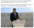
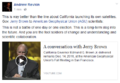
 Rising seas Isaac Cordel.jpg 718 × 466; 78 KB
 Rising Seas NatGeo M Sept13 s.jpg 226 × 66; 8 KB
 Rising Seas NatGeo M Sept13.jpg 275 × 400; 37 KB
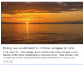 Rising Seas, refugees, Phys.org Land Use July 2017.png 488 × 385; 190 KB
 Rising.jpg 381 × 640; 33 KB
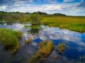 Salt-water marsh sea-level rise.jpg 684 × 512; 65 KB
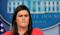 Sarah Sanders press conf-Nov 2018.png 448 × 262; 291 KB
 Saudi Arabia and Middle East - Hot in May 2024.png 640 × 410; 506 KB
 Scale of energy use-2000-2016.jpg 800 × 673; 69 KB
 School strike for climate countries.png 800 × 411; 106 KB
 Science & Solutions - 2020 - Project Drawdown - NCSE Conf.jpg 800 × 351; 56 KB
 Science & Solutions - 2020 - Project Drawdown - NCSE.jpg 800 × 261; 66 KB
 Science and Climate Hearing March29,2017.png 800 × 281; 240 KB
 SCOTUS decision on water protection.png 535 × 424; 299 KB
 SCOTUS EPA decision - June 30 2022.jpg 794 × 778; 168 KB
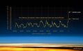
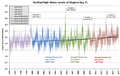 Sea level rise Miami area tide data 1996-2015.png 660 × 417; 115 KB
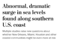 Sea levels surge along southern US coast.png 640 × 441; 69 KB
 Sea Wall of Miami +++.jpg 526 × 220; 48 KB
 Sea-level rise flooding map.png 448 × 426; 219 KB
 Sea-Level Rise Twice as High as Previously Predicted.png 701 × 225; 92 KB
 SeaLevelRise-populationimpact.jpg 634 × 356; 47 KB
 Senate votes on methane - April 28, 2021.jpg 640 × 377; 77 KB
 Sentinel-6 launched 11-21-2020.jpg 361 × 103; 12 KB
 Shell lawsuit Feb 2023.png 768 × 534; 229 KB
 Short Circuiting Policy - by Leah Stokes.jpg 595 × 423; 94 KB
 Shrinking Shores Florida.png 750 × 336; 328 KB
 Slash emission now or face climate disaster.jpg 800 × 579; 94 KB
 Small Island Developing States SIDS list as of Jan 2016.png 872 × 563; 278 KB
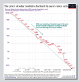 Solar panel price - 1976-2019.png 596 × 612; 92 KB
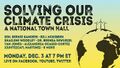 Solving our climate crisis a national townhall-dec3,2018.jpg 640 × 360; 55 KB
 SouthFloridaSLR 2s-.gif 800 × 471; 349 KB
 SSP Baselines-projections 2018-2100.png 393 × 406; 42 KB
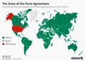 State of the paris agreement nov2019.jpg 800 × 570; 178 KB
 Storm surge can be deadly.png 457 × 640; 118 KB
 StratDem Strategic Demands.png 768 × 1,024; 626 KB
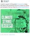
 Strike - Sept 20.jpg 754 × 754; 44 KB
 SunriseBmore March 1, 2021.jpg 593 × 622; 187 KB
 Supreme Court decision on GHG emission cost metric - May 2022.png 640 × 442; 419 KB
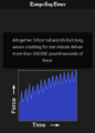
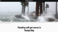 Tampa Bay Flooding Will Get Worse.png 800 × 439; 599 KB


.png)


![[1]](https://www.greenpolicy360.net/w/File:Florida_sea_rise_ab.jpg)
![[2]](https://www.greenpolicy360.net/w/File:Florida_sea_rise_c.jpg)
![[3]](https://www.greenpolicy360.net/w/File:Florida-sea-level-rise.jpg)