Earth Science Research from Space: Difference between revisions
Siterunner (talk | contribs) No edit summary |
Siterunner (talk | contribs) No edit summary |
||
| Line 9: | Line 9: | ||
○ ○ ○ ○ ○ ○ ○ ○ ○ ○ ○ ○ ○ ○ ○ ○ ○ ○ ○ ○ ○ ○ ○ ○ ○ ○ ○ ○ ○ ○ ○ ○ ○ ○ | ○ ○ ○ ○ ○ ○ ○ ○ ○ ○ ○ ○ ○ ○ ○ ○ ○ ○ ○ ○ ○ ○ ○ ○ ○ ○ ○ ○ ○ ○ ○ ○ ○ ○ | ||
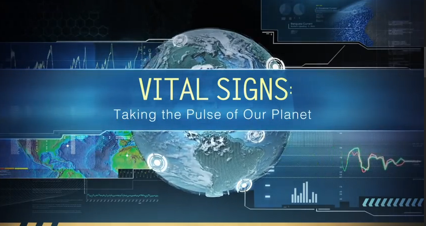
== ''"Vital Signs", Monitoring the Earth by Satellite'' == | == ''"Vital Signs", Monitoring the Earth by Satellite'' == | ||
Revision as of 18:12, 31 October 2015
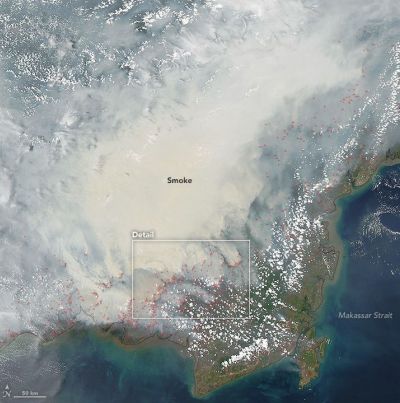
Only "the greatest environmental disaster of the 21st Century (so far)"
Eco-disaster viewed from Earth Observatory NASA satellite
○ ○ ○ ○ ○ ○ ○ ○ ○ ○ ○ ○ ○ ○ ○ ○ ○ ○ ○ ○ ○ ○ ○ ○ ○ ○ ○ ○ ○ ○ ○ ○ ○ ○
"Vital Signs", Monitoring the Earth by Satellite
○ ○ ○ ○ ○ ○ ○ ○ ○ ○ ○ ○ ○ ○ ○ ○ ○ ○ ○ ○ ○ ○ ○ ○ ○ ○ ○ ○ ○ ○ ○ ○ ○ ○ ○ ○ ○ ○ ○ ○ ○ ○ ○ ○ ○ ○
Latest from the Atmospheric Science Data Center (ASDC) at NASA Langley Research Center
NASA Earth science data in the areas of radiation budget, clouds, aerosols, and tropospheric chemistry
https://eosweb.larc.nasa.gov/ --- https://eosweb.larc.nasa.gov/projects-supported
April 2015
From Above We See Our Planet High Definition Video, from NASA
March 2015
One of the many critical NASA earth science missions from space reports:
http://www.nature.com/ngeo/journal/vaop/ncurrent/full/ngeo2388.html
http://www.ig.utexas.edu/research/projects/icecap/
http://www.nasa.gov/mission_pages/icebridge/
○
- DSCOVR is launched and on its way!
February 12, 2015 The DSCOVR satellite with its EPIC cam, PlasMag & NISTAR instrument package is on the way... a million mile journey, scheduled to light up, be tested and begin delivering data to Earth in August, including near-real-time imaging of Earth provided online – We will be delivering a stream of amazing imagery of our planet as NASA/NOAA begin uploading EPICs pictures of us!
○
It's been some time since December 7, 1972 when the only picture ever snapped by a human of the whole earth was captured -- our iconic "Blue Marble" -- Engineers that they are, NASA named the image -- AS17-148-22727
As we have been recalling the history, we haven't had returned to us a 'whole earth' image since 1972. Today, Feb 10, the Associated Press reports Sen. Bill Nelson, D-Florida, pointing out from Washington that there hasn't been a full, sunlit picture of the Earth since Apollo 17 in 1972 - NASA's last manned moon-landing mission. Subsequent images have been stitched together, the Senator explained, for composite shots. The Senator has an exceptional point of view as he was an astronaut -- In January 1986, Nelson spent six days orbiting Earth as a payload specialist aboard space shuttle Columbia. His NASA bio adds "The experience gave him a new perspective on the Earth’s fragile environment and a greater appreciation of the importance of our nation’s space exploration program."
The DSCOVR satellite launches into deep orbit with multiple missions -- to monitor space weather and, due to the satellite's orbital distance from Earth (1 mil miles), DSCOVR will be sending back daily images of the 'whole earth' via its EPIC image-taking system and via its NISTAR system measuring earth's earth's temperature, our "radiation balance" ("albedo").
○ ○ ○ ○
- ISS mission to monitor #planethome
○ ○ ○ ○
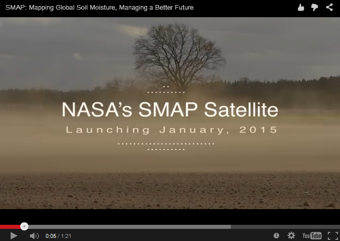
- Time to measure earth soil moisture content -- SMAP
January 2015
Scheduled to launch Jan 29th to "measure the moisture in Earth's soils with unprecedented accuracy and resolution.
○ ○ ○ ○
- Existential -- Monitoring "vital signs", over time a baseline of planet earth
December 2014
Global Warming / NASA OCO Satellite Sends Back Most Detailed CO2 View Ever / Dec 18
Initial round of CO2data is made available...
A first full set of CO2 data will likely be available after March 2015 for scientists and public to download and explore.
More on the history-making OCO-2 / Orbiting Carbon Observatory
According to JPL scientists: "Where OCO-2 really excels is the sheer amount of data being collected within a day, about one million measurements across a narrow swath... For fluorescence, this enables us, for the first time, to look at features on the five- to 10-kilometer scale on a daily basis." SIF can be measured even through moderately thick clouds, so it will be especially useful in understanding regions like the Amazon where cloud cover thwarts most spaceborne observations."
The changes in atmospheric carbon dioxide that OCO-2 seeks to measure are so small that the mission must take unusual precautions to ensure the instrument is free of errors. For that reason, the spacecraft was designed so that it can make an extra maneuver. In addition to gathering a straight line of data like a lawnmower swath, the instrument can point at a single target on the ground for a total of seven minutes as it passes overhead. That requires the spacecraft to turn sideways and make a half cartwheel to keep the target in its sights.
The targets OCO-2 uses are stations in the Total Carbon Column Observing Network (TCCON), a collaborative effort of multiple international institutions. TCCON has been collecting carbon dioxide data for about five years, and its measurements are fully calibrated and extremely accurate. At the same time that OCO-2 targets a TCCON site, a ground-based instrument at the site makes the same measurement. The extent to which the two measurements agree indicates how well calibrated the OCO-2 sensors are.
Additional maps released recently showed the results of these targeting maneuvers over two TCCON sites in California and one in Australia. "Early results are very promising," said Paul Wennberg, a professor at Caltech and head of the TCCON network. "Over the next few months, the team will refine the OCO-2 data, and we anticipate that these comparisons will continue to improve."
More about the OCO-2 mission, making history as it reveals the extent of atmospheric CO2
○ ○ ○ ○
- Tracking ocean currents, 'best-ever data
November 2014
Scientists produce "the most accurate space view yet of global ocean currents and the speed they move..."
http://www.greenpolicy360.net/mw/images/Ocean_currents_from_GOCE_20141125-jpg.jpg
○ ○ ○ ○
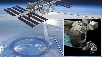
New NASA ERA
Sept 08, 2014 - NASA opens a new era in its exploration of our home planet with the launch of the first in a series of Earth science instruments to the International Space Station, Earth-observing instruments to be mounted on the exterior of the #ISS. ISS-RapidScat will monitor ocean winds for climate research, weather predictions and hurricane monitoring. The second instrument is the Cloud-Aerosol Transport System (CATS), a laser instrument that will measure clouds and the location and distribution of pollution, dust, smoke, and other particulates in the atmosphere. Look closer at the array of instruments #RapidScat #EarthRightNow
○ ○ ○ ○
Ice impacts of Climate Change -- Arctic/Antarctic
The Antarctic: Big Melt Accelerates / Antarctic Ice Sheet Expands

The Antarctic: Big Melt Accelerates [1] [2] Antarctic Ice Sheet Expands, Why? [3]
○
May 2014
Doubling-of-antarctic-ice-loss-revealed-by-european-satellite
Melting New assessments of impacts of global warming come from Europe's Cryosat spacecraft.
The CryoSat is part of the Living Planet Programme [4] [5] [6] [7] of the European Space Agency. [8]
Cooperative earth monitoring science between US-Europe
More data re ice melt-Grace/US-NASA [9] [10]
○ ○ ○ ○
Earth Observing System satellites -- first-gen earth monitoring from space / European space agency
Earth-observing satellites for earth system monitoring include:
The European Space Agency "Living Planet Programme" managed by Earth Observation Programmes - [11]
- GOCE – Gravity Field and Steady-State Ocean Circulation Explorer - launched on March 17, 2009 - [12]
- SMOS – Soil Moisture and Ocean Salinity satellite - studying ocean salinity and soil moisture; launched in 2 November 2009 - [13]
- CryoSat is designed to map the Earth's ice cover. CryoSat-1 was lost in 2005. CryoSat-2 was launched 8 April 2010 - [14]
- Swarm – is a trio of satellites to map the Earth's magnetism. The SWARM constellation was launched successfully on 22 November 2013 - [15]
- Aeolus – Atmospheric Dynamics Mission will use an innovative laser to measure winds. Due for launch in 2015 - [16]
- EarthCARE – Earth Clouds Aerosols and Radiation Explorer will examine the formation and effects of clouds. Due for launch in 2016 - [17]
- BIOMASS is designed to calculate the amount of carbon stored in the world's forests, and to monitor for any changes over the course of its five-year mission. Due to launch in 2020 - [18]
The European Space Agency's mission:
To benefit citizens "asking for a better quality of life on earth... for greater security and economic wealth... to pursue dreams, to increase knowledge... for younger people to be attracted to the pursuit of science and technology... ESA's purpose shall be to provide for, and to promote, for exclusively peaceful purposes, cooperation in space research and technology and space applications, with a view to their being used for scientific purposes..."
○ ○ ○ ○
New Space, "democratization of space", start-up ventures, #EarthScience with low-cost, microSats and open data
New Space, Monitoring the Earth by Satellite

Polar Clouds from the ISS, Sept. 2014
○ ○ ○ ○
Planet Citizen | #PlanetCitizen
GreenPolicy360 | #Earth360 | #EarthImaging | #EarthMonitoring
GP360 | #EarthObservations | #EarthScience | #NewSpace
#EarthPOV | Earth Point of View
○ ○ ○ ○
Beginnings of the Ocean Food Chain -- Ocean Ecosystem Monitored from Space http://en.wikipedia.org/wiki/Marine_ecosystem
http://www.greenpolicy360.net/w/File:Phytoplankton.jpg


- Biodiversity
- Earth360
- Earth Law
- Earth Observations
- Earth Science
- Earth Science from Space
- Ecology Studies
- Environmental Full-cost Accounting
- Environmental Security, National Security
- EOS eco Operating System
- Externalities
- ISS
- Land Ethic
- New Space
- Oceans
- Ocean Ecosystem
- Ocean Science
- Ocean Sustainability
- Planet Citizen
- Planet Scientist
- Planet Citizens, Planet Scientists
- Solar Energy
- Sustainability
- Sustainability Policies
- ThinBlueLayer
- Atmospheric Science
- Biogeosciences
- Climate Change
- Cryosphere
- Geophysics and Geochemistry
- Mineralogy
- Geology
- Geophysics
- Hydrology
- Natural Resources
- Planetary Science
- Space Science and Space Physics