File:US River basins - watersheds.jpg: Difference between revisions
Jump to navigation
Jump to search
Siterunner (talk | contribs) No edit summary |
Siterunner (talk | contribs) No edit summary |
||
| Line 2: | Line 2: | ||
River Basins-Watershed Maps avail at GrasshopperGeography - https://www.etsy.com/shop/GrasshopperGeography?section_id=20096462 | River Basins-Watershed Maps avail at GrasshopperGeography - https://www.etsy.com/shop/GrasshopperGeography?section_id=20096462 | ||
US Maps created by Imgur user Fejetlenfej | |||
Visit http://imgur.com/gallery/N4cUA for US mapping | Visit http://imgur.com/gallery/N4cUA for US mapping | ||
: http://www.dailymail.co.uk/sciencetech/article-3860062/The-veins-America-Stunning-map-shows-river-basin-US.html | |||
Read More / Oct 2016 | |||
:http://www.dailymail.co.uk/sciencetech/article-3860062/The-veins-America-Stunning-map-shows-river-basin-US.html | |||
:http://www.greenpolicy360.net/w/Landsat_data_users_handbook | |||
Revision as of 16:11, 22 October 2016
River Basins-Watershed Maps avail at GrasshopperGeography - https://www.etsy.com/shop/GrasshopperGeography?section_id=20096462
US Maps created by Imgur user Fejetlenfej
Visit http://imgur.com/gallery/N4cUA for US mapping
Read More / Oct 2016
File history
Click on a date/time to view the file as it appeared at that time.
| Date/Time | Thumbnail | Dimensions | User | Comment | |
|---|---|---|---|---|---|
| current | 16:08, 22 October 2016 | 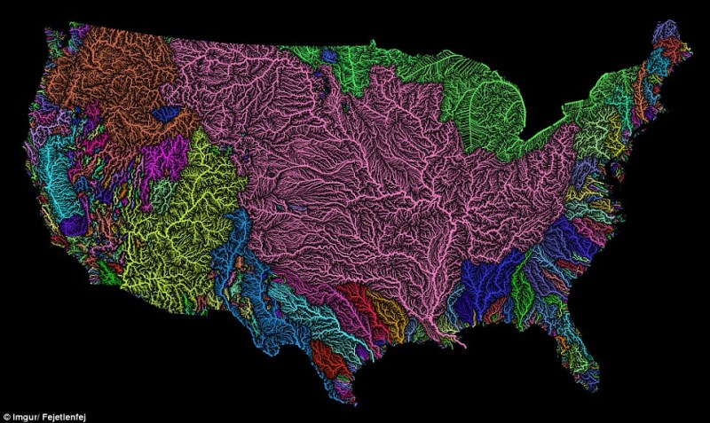 | 800 × 477 (131 KB) | Siterunner (talk | contribs) |
You cannot overwrite this file.
File usage
The following 4 pages use this file:
Categories:
- Agricultural Economics
- Agriculture
- Democratization of Space
- Earth360
- EarthPOV
- Earth Art
- Earth Observations
- Earth Science
- Earth Science from Space
- Environmental Protection
- Global Security
- NASA
- New Space
- Planet API
- Planet Citizen
- Planet Citizens, Planet Scientists
- Space Science and Space Physics
- Whole Earth
- Alternative Agriculture
- Aquifers
- Appropriate Technology
- Biodiversity
- Bioneers
- Biogeosciences
- Bioregionalism
- Eco-nomics
- Ecology Studies
- Ecoregions
- Farm-Related Policies
- Food
- Food-Related Policies
- Green Best Practices
- Land Ethic
- Permaculture
- Resilience
- Soil
- Sustainability
- Sustainability Policies
- Tasmania
- Water
- Watersheds
- Wetlands
- Atmospheric Science
- Climate Change
- Climate Policy
- Planetary Science