File:Landsat NASA - Feb 11 2023.png: Difference between revisions
Siterunner (talk | contribs) No edit summary |
Siterunner (talk | contribs) No edit summary |
||
| (3 intermediate revisions by the same user not shown) | |||
| Line 1: | Line 1: | ||
<big>'''Landsat Flying for Over Fifty Years'''</big> | |||
:The beginnings of digital imaging of Planet Earth | |||
::In memory of "Planet Citizens, Planet Scientists" George E. Brown & Virginia Tower Norwood | |||
Landsat 8 and memories of the team of visionaries back at the beginning of the Landsat program who proposed, developed, invented (digital scanning) and then protected the Landsat earth science/remote imaging program over the first decades. Now, as the data of earth imagery provides the unique resources for scientists/educators/climate study/earth system dynamics and changes over five+ decades, we at GreenPolicy360 give a generational green appreciation! The ''[[Generation Green]]''' work has made a positive difference in all of our lives!! The Landsat legacy carries on.... | |||
* https://www.greenpolicy360.net/w/George_E._Brown_Jr | |||
* https://www.greenpolicy360.net/w/LANDSAT_and_Virginia_Tower_Norwood | |||
* https://twitter.com/NASAEarth/status/1624530349265920000 | |||
* https://www.greenpolicy360.net/w/Landsat_data_users_handbook | |||
* https://www.greenpolicy360.net/w/New_Definitions_of_National_Security | |||
[[File:Landsat, a 50 year legacy.png]] | |||
[[File:Multispectral Scanning Systen - MSS.jpg]] | |||
🌎 | |||
[[Category:Maps]] | |||
[[Category:About Us]] | |||
[[Category:Agricultural Economics]] | |||
[[Category:Agriculture]] | |||
[[Category:Democratization of Space]] | |||
[[Category:Digital Citizen]] | |||
[[Category:Earth360]] | |||
[[Category:EarthPOV]] | |||
[[Category:Earth Art]] | |||
[[Category:Earth Imaging]] | |||
[[Category:Earth Observations]] | |||
[[Category:Earth Science]] | |||
[[Category:Earth Science from Space]] | |||
[[Category:Earth System Science]] | |||
[[Category:Ecology Studies]] | |||
[[Category:Education]] | |||
[[Category:Environmental Protection]] | |||
[[Category:Global Security]] | |||
[[Category:Green Graphics]] | |||
[[Category:GreenPolicy360]] | |||
[[Category:Green Politics]] | |||
[[Category:Land Use]] | |||
[[Category:NASA]] | |||
[[Category:New Definitions of National Security]] | |||
[[Category:New Space]] | |||
[[Category:Planet API]] | |||
[[Category:Planet Citizen]] | |||
[[Category:Planet Citizens, Planet Scientists]] | |||
[[Category:Planet Citizens, Planet Scientists]] | |||
[[Category:Space Science and Space Physics]] | |||
[[Category:Whole Earth]] | |||
[[Category:Alternative Agriculture]] | |||
[[Category:Aquifers]] | |||
[[Category:Appropriate Technology]] | |||
[[Category:Biodiversity]] | |||
[[Category:Bioneers]] | |||
[[Category:Biogeosciences]] | |||
[[Category:Bioregionalism]] | |||
[[Category:Eco-ethics]] | |||
[[Category:Eco-nomics]] | |||
[[Category:Ecoregions]] | |||
[[Category:EOS eco Operating System]] | |||
[[Category:Farm-Related Policies]] | |||
[[Category:Food]] | |||
[[Category:Food-Related Policies]] | |||
[[Category:Global Security]] | |||
[[Category:Green Best Practices]] | |||
[[Category:Land Ethic]] | |||
[[Category:Permaculture]] | |||
[[Category:Resilience]] | |||
[[Category:Sea-level Rise]] | |||
[[Category:Soil]] | |||
[[Category:Strategic Demands]] | |||
[[Category:Sustainability]] | |||
[[Category:Sustainability Policies]] | |||
[[Category:Water]] | |||
[[Category:Watersheds]] | |||
[[Category:Wetlands]] | |||
[[Category:Atmospheric Science]] | |||
[[Category:Biogeosciences]] | |||
[[Category:Climate Change]] | |||
[[Category:Climate Policy]] | |||
[[Category:Planetary Science]] | |||
Latest revision as of 20:28, 30 September 2023
Landsat Flying for Over Fifty Years
- The beginnings of digital imaging of Planet Earth
- In memory of "Planet Citizens, Planet Scientists" George E. Brown & Virginia Tower Norwood
Landsat 8 and memories of the team of visionaries back at the beginning of the Landsat program who proposed, developed, invented (digital scanning) and then protected the Landsat earth science/remote imaging program over the first decades. Now, as the data of earth imagery provides the unique resources for scientists/educators/climate study/earth system dynamics and changes over five+ decades, we at GreenPolicy360 give a generational green appreciation! The Generation Green' work has made a positive difference in all of our lives!! The Landsat legacy carries on....


🌎
File history
Click on a date/time to view the file as it appeared at that time.
| Date/Time | Thumbnail | Dimensions | User | Comment | |
|---|---|---|---|---|---|
| current | 19:48, 12 February 2023 | 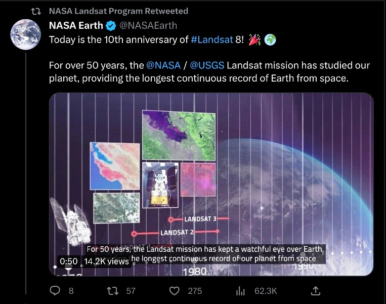 | 763 × 600 (578 KB) | Siterunner (talk | contribs) |
You cannot overwrite this file.
File usage
The following 2 pages use this file:
- Maps
- About Us
- Agricultural Economics
- Agriculture
- Democratization of Space
- Digital Citizen
- Earth360
- EarthPOV
- Earth Art
- Earth Imaging
- Earth Observations
- Earth Science
- Earth Science from Space
- Earth System Science
- Ecology Studies
- Education
- Environmental Protection
- Global Security
- Green Graphics
- GreenPolicy360
- Green Politics
- Land Use
- NASA
- New Definitions of National Security
- New Space
- Planet API
- Planet Citizen
- Planet Citizens, Planet Scientists
- Space Science and Space Physics
- Whole Earth
- Alternative Agriculture
- Aquifers
- Appropriate Technology
- Biodiversity
- Bioneers
- Biogeosciences
- Bioregionalism
- Eco-ethics
- Eco-nomics
- Ecoregions
- EOS eco Operating System
- Farm-Related Policies
- Food
- Food-Related Policies
- Green Best Practices
- Land Ethic
- Permaculture
- Resilience
- Sea-level Rise
- Soil
- Strategic Demands
- Sustainability
- Sustainability Policies
- Water
- Watersheds
- Wetlands
- Atmospheric Science
- Climate Change
- Climate Policy
- Planetary Science