File:Landsat data site.png: Difference between revisions
Siterunner (talk | contribs) No edit summary |
Siterunner (talk | contribs) No edit summary |
||
| Line 57: | Line 57: | ||
[[Category:Green Best Practices]] | [[Category:Green Best Practices]] | ||
[[Category:Green Graphics]] | [[Category:Green Graphics]] | ||
[[Category:GreenPolicy360]] | |||
[[Category:Land Ethic]] | [[Category:Land Ethic]] | ||
[[Category:Permaculture]] | [[Category:Permaculture]] | ||
Revision as of 12:49, 17 September 2023
First, a Map of the Entire U.S.—and Then the World
The USGS Earth Resources Observation and Science (EROS) Center, celebrating its 50th anniversary this year, was developed at the beginning of the Landsat Earth observation satellite program as a place to store and distribute the imagery. Through the years, EROS has become much more—including a place to advance land cover mapping and monitoring through an unbiased scientific lens...
In the 1980s, as EROS began its International Program, a different type of satellite data factored in. TheAdvanced Very High Resolution Radiometer (AVHRR) sensor aboard National Oceanic and Atmospheric Administration (NOAA) meteorological satellites could cover the entire Earth in one day at a coarse scale and reveal information about vegetation cover and conditions.
○
File history
Click on a date/time to view the file as it appeared at that time.
| Date/Time | Thumbnail | Dimensions | User | Comment | |
|---|---|---|---|---|---|
| current | 12:37, 17 September 2023 | 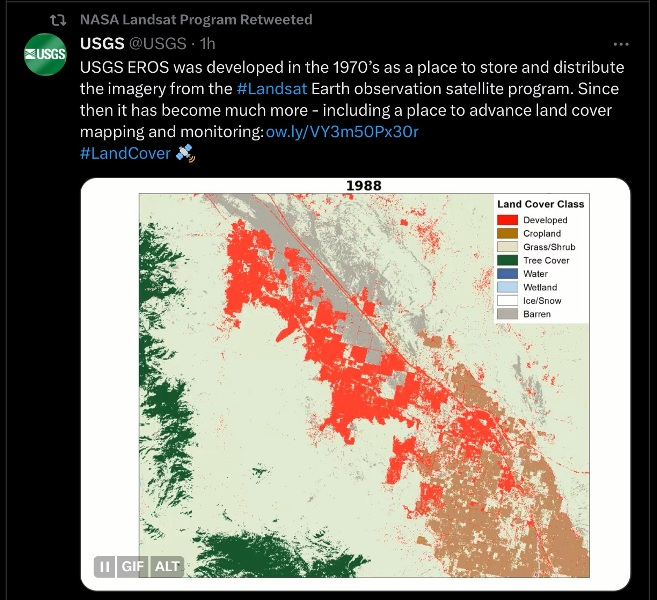 | 657 × 600 (499 KB) | Siterunner (talk | contribs) |
You cannot overwrite this file.
File usage
The following 2 pages use this file:
- Maps
- Agricultural Economics
- Agriculture
- Democratization of Space
- Earth360
- EarthPOV
- Earth Art
- Earth Observations
- Earth Science
- Earth Science from Space
- Environmental Protection
- Global Security
- Green Politics
- Land Use
- NASA
- New Space
- Planet API
- Planet Citizen
- Planet Citizens, Planet Scientists
- Space Science and Space Physics
- Whole Earth
- Alternative Agriculture
- Aquifers
- Appropriate Technology
- Biodiversity
- Bioneers
- Biogeosciences
- Bioregionalism
- Eco-nomics
- Ecology Studies
- Ecoregions
- EOS eco Operating System
- Farm-Related Policies
- Food
- Food-Related Policies
- Green Best Practices
- Green Graphics
- GreenPolicy360
- Land Ethic
- Permaculture
- Resilience
- Sea-level Rise
- Soil
- Strategic Demands
- Sustainability
- Sustainability Policies
- Water
- Watersheds
- Wetlands
- Atmospheric Science
- Climate Change
- Climate Policy
- Planetary Science