File:DSCOVR-EPIC ImagingofPlanetEarth.png
DSCOVR-EPIC_ImagingofPlanetEarth.png (316 × 266 pixels, file size: 19 KB, MIME type: image/png)
View DSCOVR Images -- http://epic.gsfc.nasa.gov/
Earth Science Research from Space

<addthis />
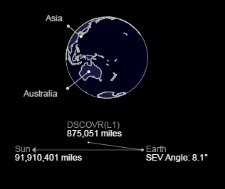
PLANET EARTH as seen from DSCOVR's EPIC System
- Earth Polychromatic Imaging Camera
Daily Views of Earth Available on New NASA Website
○ ○ ○ ○ ○ ○ ○ ○ ○ ○ ○ ○ ○ ○ ○ ○ ○ ○
America’s first operational deep space satellite
DSCOVR successfully launched on February 11, 2015 from Cape Canaveral, Florida. It took the satellite just over 100 days to reach its final orbit at Lagrange point 1, orbiting nearly one million miles from Earth. Positioned between the sun and Earth, DSCOVR is able to maintain a constant view of the sun and sun-lit side of Earth.
○
File history
Click on a date/time to view the file as it appeared at that time.
| Date/Time | Thumbnail | Dimensions | User | Comment | |
|---|---|---|---|---|---|
| current | 09:32, 19 November 2015 | | 316 × 266 (19 KB) | Siterunner (talk | contribs) | http://epic.gsfc.nasa.gov/ [http://www.earthpov.com EarthPOV.com] Category:Biosphere Category:Democratization of Space Category:Earth360 Category:EarthPOV Category:Earth Observations Category:Earth Science [[Category:Environme... |
You cannot overwrite this file.
File usage
The following 3 pages use this file: