File:DSCOVR w EPICcam, PlasMag & NISTAR.png: Difference between revisions
Siterunner (talk | contribs) No edit summary |
Siterunner (talk | contribs) No edit summary |
||
| Line 23: | Line 23: | ||
----------- | ----------- | ||
Q: How long is the DSCOVR mission? | Q: How long is the DSCOVR mission? | ||
| Line 59: | Line 53: | ||
NASA received funding from NOAA to refurbish the DSCOVR spacecraft and its solar wind instruments, develop the ground segment, and manage launch and activation of the satellite. The Air Force funds and oversees the launch services for DSCOVR. DSCOVR will also host NASA-funded secondary sensors for Earth and space science observations. The Earth science data will be processed at NASA’s DSCOVR Science Operations Center and archived and distributed by NASA’s Atmospheric Science Data Center. | NASA received funding from NOAA to refurbish the DSCOVR spacecraft and its solar wind instruments, develop the ground segment, and manage launch and activation of the satellite. The Air Force funds and oversees the launch services for DSCOVR. DSCOVR will also host NASA-funded secondary sensors for Earth and space science observations. The Earth science data will be processed at NASA’s DSCOVR Science Operations Center and archived and distributed by NASA’s Atmospheric Science Data Center. | ||
----- | ----- | ||
DSCOVR and EPIC... For many Earth scientists, the centerpiece of the satellite is the National Institute of Standards Advanced Radiometer, or NISTAR, named for the Maryland-based government laboratory that designed it. The apparatus was built to shed light on Earth’s “radiation balance”—the radiation we receive from our sun minus the radiation we reflect back into space. The difference is retained by our planet as heat, and is calculated by measuring Earth’s reflectivity, called the albedo. Data showing whether Earth’s albedo is decreasing, meaning the atmosphere is retaining more heat because of greenhouse gases or other reasons, could be a significant piece of the climate puzzle. | DSCOVR and EPIC... For many Earth scientists, the centerpiece of the satellite is the National Institute of Standards Advanced Radiometer, or NISTAR, named for the Maryland-based government laboratory that designed it. The apparatus was built to shed light on Earth’s “radiation balance”—the radiation we receive from our sun minus the radiation we reflect back into space. The difference is retained by our planet as heat, and is calculated by measuring Earth’s reflectivity, called the albedo. Data showing whether Earth’s albedo is decreasing, meaning the atmosphere is retaining more heat because of greenhouse gases or other reasons, could be a significant piece of the climate puzzle. | ||
| Line 69: | Line 61: | ||
------ | ------ | ||
For GreenPolicy360, the centerpiece of the mission will be the EPIC cam images of Earth 360 -- the first whole earth pictures to be delivered to us since 1972 -- images of us we are looking to share as a message of our home planet | |||
Planet Citizens as we are -- together | |||
------ | |||
http://www.greenpolicy360.net/w/File:EPIC_cam.jpg | http://www.greenpolicy360.net/w/File:EPIC_cam.jpg | ||
Revision as of 01:25, 13 February 2015
Feb 12, 2015 / Launched w SpaceX
DSCOVR satellite... w its EPIC cam, PlasMag & NISTAR instrument package is on the way... a million miles toward the Sun then 'parked' in orbit to send data of/to earth, incl first whole earth photos since 1972
Modern-day Blue Marble-like photos have to be stitched together from composite images. (The default iPhone background is one of these composites.)
DSCOVR w EPIC cam, PlasMag & NISTAR
The Earth science data will be processed at NASA’s DSCOVR Science Operations Center and archived and distributed by NASA’s Atmospheric Science Data Center. Earth Polychromatic Imaging Camera (EPIC)
http://www.nasa.gov/content/goddard/noaas-dscovr-to-provide-epic-views-of-earth/
http://www.nesdis.noaa.gov/DSCOVR/pdf/DSCOVR%20-%20EPIC%20Instrument%20Info%20Sheet.pdf
http://www.nesdis.noaa.gov/DSCOVR/
http://mediaarchive.ksc.nasa.gov/search.cfm?cat=278%C2%A0%C2%A0%C2%A0
Q: How long is the DSCOVR mission?
A: It is planned for a 2-year mission with fuel that can last 5 years.
Q: What frequency of space weather events require responses?
A: DSCOVR will be looking for high-speed solar winds that can cause problems and damages to satellites. Space weather from CMEs cause most damage. Storms are fairly common, but warnings help reduce impacts.
Q: Can you give an example of widely-felt CME impact?
A: One CME event affected an aviation system and changed way aircraft approaches are done. Another system was knocked off line for months. The Carrington event (1859) caused massive damage to the telegraph system of the day, and would be devastating today to modern computer systems and the power grid without early warning.
Q: What is the difference between ACE and DSCOVR?
A: ACE was a 9-instrument solar research satellite launched in August 1997, while DSCOVR is a 3-instrument solar operational satellite (and a 6 instrument research satellite. There are 2 Earth science instruments, and minor Pulse Height Analyzer instrument to study effect of space weather and cosmic rays on electronics.). Both spacecraft transmit solar wind particle and magnetic field data in real time to the NOAA Space Weather Prediction Center. As an operational spacecraft, the DSCOVR instrumentation is more robust against outages caused by solar storms. Less significantly, DSCOVR provides faster cadence, once every 10 seconds data as opposed to ACE’s once every 1 minute.
A: It takes 115 days to reach orbit in L-1 or Lagrange 1 point. NASA will likely hand over DSCOVR to NOAA in mid-summer timeframe. http://www.nasa.gov/content/goddard/noaas-dscovr-to-provide-epic-views-of-earth/#.VNzn9C744Rk "Unlike personal cameras, EPIC will take images in 10 very narrow wavelength ranges," said Adam Szabo, DSCOVR project scientist at NASA's Goddard Space Flight Center, Greenbelt, Maryland. "Combining these different wavelength images allows the determination of physical quantities like ozone, aerosols, dust and volcanic ash, cloud height, or vegetation cover. These results will be distributed as different publicly available data products allowing their combination with results from other missions."
Q: Have modifications been made to EPIC to enhance its Earth science measurements?
A: Original EPIC instrument concept is similar to current configuration. Improvements were made in all narrow-length wavelength bands to reduce stray light and to add new cloud height measurements. Ozone, aerosols, cloud amount, and vegetation were all in original design. Wavelength changes were made based on other earth-observing satellites over the last 15 years. Earth science data will be obtained about every 2 hours and downloaded to earth whenever the large Wallops Island antenna is in view.
The DSCOVR mission is a partnership between NOAA, NASA, and the U.S. Air Force. NOAA will operate DSCOVR from its NOAA Satellite Operations Facility in Suitland, Maryland, and process data at NOAA's Space Weather Prediction Center (SWPC) in Boulder, Colorado, for distribution to users within the United States and around the world. The data will be archived at NOAA’s National Geophysical Data Center also in Boulder. The U.S. Air Force is providing the launch vehicle for the DSCOVR mission and the responsibility for all launch vehicle associated mission assurance.
NASA received funding from NOAA to refurbish the DSCOVR spacecraft and its solar wind instruments, develop the ground segment, and manage launch and activation of the satellite. The Air Force funds and oversees the launch services for DSCOVR. DSCOVR will also host NASA-funded secondary sensors for Earth and space science observations. The Earth science data will be processed at NASA’s DSCOVR Science Operations Center and archived and distributed by NASA’s Atmospheric Science Data Center.
DSCOVR and EPIC... For many Earth scientists, the centerpiece of the satellite is the National Institute of Standards Advanced Radiometer, or NISTAR, named for the Maryland-based government laboratory that designed it. The apparatus was built to shed light on Earth’s “radiation balance”—the radiation we receive from our sun minus the radiation we reflect back into space. The difference is retained by our planet as heat, and is calculated by measuring Earth’s reflectivity, called the albedo. Data showing whether Earth’s albedo is decreasing, meaning the atmosphere is retaining more heat because of greenhouse gases or other reasons, could be a significant piece of the climate puzzle.
What was revolutionary wasn’t the basic technology for tracking albedo—it was measuring it from the million-mile perspective out at L1. Most satellites circle the planet at about one-thousandth of that distance, so their readings encompass only a small slice of land, a view that shifts rapidly as they circle the planet every two hours or so. Different climate zones—ice caps, deserts, tropical forests—have different reflectivities, independent of the atmosphere, which needs to be factored in to the overall measurement; it’s virtually impossible to create a whole-Earth portrait from a deck of low-orbit snapshots. “By the time you stitch together all the separate bits of data, the margin of error is too large to be useful,” Asrar says. “DSCOVR, on the other hand, would be like having a thermometer for the whole planet.” It’s not a perfect gauge, NASA’s Szabo cautions. “Earth is…a sphere that reflects light in all directions. So a measurement from any one point will not be the final word. But it will still be very important for the conversation about climate change.”
For GreenPolicy360, the centerpiece of the mission will be the EPIC cam images of Earth 360 -- the first whole earth pictures to be delivered to us since 1972 -- images of us we are looking to share as a message of our home planet
Planet Citizens as we are -- together
http://www.greenpolicy360.net/w/File:EPIC_cam.jpg

File history
Click on a date/time to view the file as it appeared at that time.
| Date/Time | Thumbnail | Dimensions | User | Comment | |
|---|---|---|---|---|---|
| current | 00:46, 13 February 2015 | 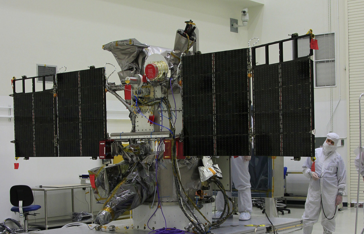 | 1,219 × 785 (1.49 MB) | Siterunner (talk | contribs) | Category:Green Graphics Category:Earth Science Category:Earth360 |
You cannot overwrite this file.
File usage
The following 2 pages use this file: