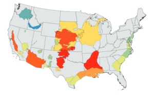
Information for "File:USGS Groundwater depletion map 2013.png"
Jump to navigation
Jump to search
View the protection log for this page.
Basic information
| Display title | File:USGS Groundwater depletion map 2013.png |
| Default sort key | USGS Groundwater depletion map 2013.png |
| Page length (in bytes) | 13,064 |
| Namespace | File |
| Page ID | 8488 |
| Page content language | en - English |
| Page content model | wikitext |
| Indexing by robots | Allowed |
| Number of redirects to this page | 0 |
| Hash value | 886fdf5ab79bda7bae95196b6a34986530be52b5 |
| Page image |  |
Page protection
| Edit | Allow all users (infinite) |
| Move | Allow all users (infinite) |
| Upload | Allow all users (infinite) |
Edit history
| Page creator | Siterunner (talk | contribs) |
| Date of page creation | 16:59, 28 May 2016 |
| Latest editor | Siterunner (talk | contribs) |
| Date of latest edit | 18:51, 28 May 2016 |
| Total number of edits | 14 |
| Total number of distinct authors | 1 |
| Recent number of edits (within past 90 days) | 0 |
| Recent number of distinct authors | 0 |