File:Tampa Bay downtown St Petersburg flooding, Regional Planning Council.jpg: Difference between revisions
Jump to navigation
Jump to search
Siterunner (talk | contribs) No edit summary |
Siterunner (talk | contribs) No edit summary |
||
| Line 1: | Line 1: | ||
Downtown St Petersburg | |||
Flood map / Tampa Bay Regional Planning Council | |||
* https://www.tampabay.com/news/environment/2020/07/11/study-it-could-cost-billions-to-get-key-tampa-bay-roads-ready-for-future-severe-weather/ | * https://www.tampabay.com/news/environment/2020/07/11/study-it-could-cost-billions-to-get-key-tampa-bay-roads-ready-for-future-severe-weather/ | ||
| Line 15: | Line 18: | ||
[[Category:Green Graphics]] | [[Category:Green Graphics]] | ||
[[Category:Resilience]] | [[Category:Resilience]] | ||
[[Category:Sea-level Rise]] | |||
[[Category:Sea-Level Rise & Mitigation]] | |||
Latest revision as of 16:26, 11 July 2020
Downtown St Petersburg
Flood map / Tampa Bay Regional Planning Council
~
File history
Click on a date/time to view the file as it appeared at that time.
| Date/Time | Thumbnail | Dimensions | User | Comment | |
|---|---|---|---|---|---|
| current | 16:20, 11 July 2020 | 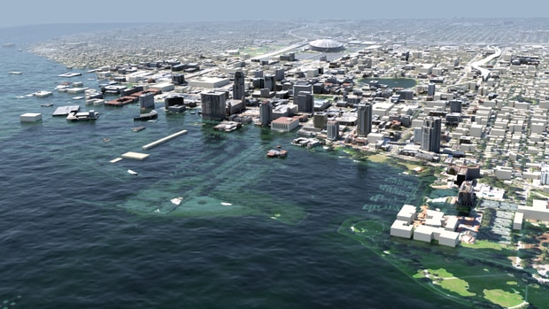 | 620 × 349 (76 KB) | Siterunner (talk | contribs) |
You cannot overwrite this file.
File usage
The following page uses this file: