File:Suomi satellite 2014.png: Difference between revisions
Siterunner (talk | contribs) No edit summary |
Siterunner (talk | contribs) No edit summary |
||
| Line 1: | Line 1: | ||
https://en.wikipedia.org/wiki/Suomi_NPP | |||
The Suomi NPP is the first in a new generation of satellites intended to replace the [https://en.wikipedia.org/wiki/Earth_Observing_System '''Earth Observing System satellites'''], which were launched from 1997 to 2011. The satellite orbits the Earth about 14 times each day. Its five imaging systems include: | |||
Advanced Technology Microwave Sounder (ATMS),[13] a microwave radiometer which will help create global moisture and temperature models | |||
Cross-track Infrared Sounder (CrIS),[14] a Michelson interferometer to monitor moisture and pressure | |||
Ozone Mapping and Profiler Suite (OMPS),[15] a group of imaging spectrometers to measure ozone levels, especially near the poles | |||
Visible Infrared Imaging Radiometer Suite (VIIRS),[16] a 22-band radiometer to collect infrared and visible light data to observe weather, climate, oceans, nightlight, wildfires, movement of ice, and changes in vegetation and landforms | |||
Clouds and the Earth's Radiant Energy System (CERES), a radiometer to detect thermal radiation, including reflected solar radiation and thermal radiation emitted by the Earth[17] | |||
[[Category:Earth Imaging]] | [[Category:Earth Imaging]] | ||
[[Category:Earth Observations]] | [[Category:Earth Observations]] | ||
Revision as of 20:53, 5 January 2016
https://en.wikipedia.org/wiki/Suomi_NPP
The Suomi NPP is the first in a new generation of satellites intended to replace the Earth Observing System satellites, which were launched from 1997 to 2011. The satellite orbits the Earth about 14 times each day. Its five imaging systems include:
Advanced Technology Microwave Sounder (ATMS),[13] a microwave radiometer which will help create global moisture and temperature models
Cross-track Infrared Sounder (CrIS),[14] a Michelson interferometer to monitor moisture and pressure
Ozone Mapping and Profiler Suite (OMPS),[15] a group of imaging spectrometers to measure ozone levels, especially near the poles
Visible Infrared Imaging Radiometer Suite (VIIRS),[16] a 22-band radiometer to collect infrared and visible light data to observe weather, climate, oceans, nightlight, wildfires, movement of ice, and changes in vegetation and landforms
Clouds and the Earth's Radiant Energy System (CERES), a radiometer to detect thermal radiation, including reflected solar radiation and thermal radiation emitted by the Earth[17]
File history
Click on a date/time to view the file as it appeared at that time.
| Date/Time | Thumbnail | Dimensions | User | Comment | |
|---|---|---|---|---|---|
| current | 15:48, 16 January 2015 | 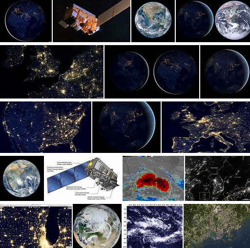 | 512 × 506 (472 KB) | Siterunner (talk | contribs) | Category:Green Graphics |
You cannot overwrite this file.
File usage
The following 3 pages use this file: