Category:Sierra Leone: Difference between revisions
Jump to navigation
Jump to search
Siterunner (talk | contribs) No edit summary |
Siterunner (talk | contribs) No edit summary |
||
| Line 16: | Line 16: | ||
Sierra Leone River Estuary, West Africa | Sentinel-2A Satellite | ESA | Sierra Leone River Estuary, West Africa | Sentinel-2A Satellite | ESA | ||
Part of Sierra Leone in West Africa is pictured in this image the Sentinel-2A satellite captured on December 11, 2015. The country’s capital, Freetown, sits on a peninsula at the bottom of the image. Its economy revolves around its natural deep water harbor—one of the world’s largest. | Part of Sierra Leone in West Africa is pictured in this image the Sentinel-2A satellite captured on December 11, 2015. | ||
The country’s capital, Freetown, sits on a peninsula at the bottom of the image. Its economy revolves around its natural deep water harbor—one of the world’s largest. | |||
[[File:Sierra Leone River estuary Dec11,2015.png]] | [[File:Sierra Leone River estuary Dec11,2015.png]] | ||
Latest revision as of 18:48, 31 January 2016
Sierra Leone Green Issues
○ ○ ○ ○ ○ ○ ○ ○ ○ ○ ○ ○ ○ ○ ○
https://en.wikipedia.org/wiki/Sierra_Leone
http://www.indexmundi.com/sierra_leone/environment_current_issues.html
http://www.globalenvironmentallaw.org/Site/Sierra_Leone.html
○
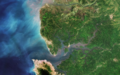
Sierra Leone River Estuary, West Africa | Sentinel-2A Satellite | ESA
Part of Sierra Leone in West Africa is pictured in this image the Sentinel-2A satellite captured on December 11, 2015.
The country’s capital, Freetown, sits on a peninsula at the bottom of the image. Its economy revolves around its natural deep water harbor—one of the world’s largest.

Media in category "Sierra Leone"
This category contains only the following file.
 Sierra Leone River estuary Dec11,2015.png 1,285 × 806; 1.77 MB