Search results
Jump to navigation
Jump to search
Page title matches

File:Free google maps pointer icon.jpg [[Category:Maps]](425 × 369 (22 KB)) - 15:27, 16 February 2017
File:Wikimedia Commons Maps of the World countries.pdf [[Category:Maps]](138 KB) - 21:12, 9 October 2013
File:Google Maps from Space July212017-800x500.png ● https://www.blog.google/products/maps/welcome-outer-space-view/ ● https://www.google.com/maps/@29.5602853,-95.0853914,3a,75y,184.87h,79.45t/data=!3m7!1e1!3m5!1szChzPIAn4(800 × 500 (991 KB)) - 15:23, 16 August 2017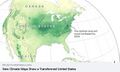
File:New Climate Maps for US.jpg [[File:New Climate Maps for US - 2020.jpg]] [[Category:Maps]](677 × 405 (47 KB)) - 01:06, 4 March 2021
File:New Climate Maps for US - 2020.jpg [[Category:Maps]](800 × 169 (34 KB)) - 22:50, 27 February 2021
File:Countries globally w maps and grn newslinks.png (871 × 329 (35 KB)) - 20:09, 31 January 2016
File:Landsat US collection of maps 1985-2021.png [[Category:Maps]](768 × 775 (1,018 KB)) - 23:53, 19 October 2022
File:Landsat-Google Maps Screen Shot 2016-06-17 Columbia Glacier.jpg https://maps.googleblog.com/2016/06/keeping-earth-up-to-date-and-looking.html(1,200 × 587 (312 KB)) - 13:39, 28 June 2016


Page text matches
File:National-park-map 800x565.jpg US National Parks Maps. ...Holly, the site currently hosts “1,198 free high-resolution national park maps to view, save, and download.”(800 × 565 (91 KB)) - 13:13, 27 February 2017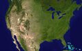
File:USA-satellitemap.jpg <small>US Maps created by Imgur user Fejetlenfej</small> [[Category:Maps]](794 × 496 (232 KB)) - 15:36, 26 May 2023File:Free google maps pointer icon.jpg [[Category:Maps]](425 × 369 (22 KB)) - 15:27, 16 February 2017
File:Map-Marker-Marker-free.png [[Category:Maps]](256 × 256 (22 KB)) - 15:31, 16 February 2017File:Wikimedia Commons Maps of the World countries.pdf [[Category:Maps]](138 KB) - 21:12, 9 October 2013
File:Wildfires-US-ESRI online-Sept2020.jpg [[Category:Maps]](552 × 499 (128 KB)) - 16:57, 13 September 2020
File:Google Earth VR-1.png [[Category:Maps]](800 × 395 (477 KB)) - 21:44, 15 October 2017
File:Google Earth VR-2.jpg [[Category:Maps]](800 × 395 (23 KB)) - 21:44, 15 October 2017
File:TheTrueSize-1.png [[Category:Maps]](1,513 × 847 (969 KB)) - 19:26, 13 November 2018
File:TheTrueSize.com 2.png [[Category:Maps]](1,024 × 573 (461 KB)) - 19:51, 13 November 2018
File:Global Forest Watch.png [[Category:Maps]](631 × 409 (67 KB)) - 00:34, 14 February 2017File:Google Maps from Space July212017-800x500.png ● https://www.blog.google/products/maps/welcome-outer-space-view/ ● https://www.google.com/maps/@29.5602853,-95.0853914,3a,75y,184.87h,79.45t/data=!3m7!1e1!3m5!1szChzPIAn4(800 × 500 (991 KB)) - 15:23, 16 August 2017
File:Travelling via Google Street View beyond agoraphobia.png [[Category:Maps]](800 × 763 (634 KB)) - 21:06, 2 February 2018
File:World GDP Graph.jpg [[Category:Maps]](700 × 600 (83 KB)) - 15:22, 5 November 2018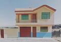
File:House in Tacna Peru.jpg [[Category:Maps]](800 × 548 (32 KB)) - 21:04, 2 February 2018
File:Radio.garden.png [[Category:Maps]](534 × 313 (244 KB)) - 18:22, 11 March 2024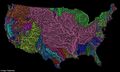
File:US River basins - watersheds.jpg River Basins-Watershed Maps avail at GrasshopperGeography - https://www.etsy.com/shop/GrasshopperGeogra US Maps created by Imgur user Fejetlenfej(800 × 477 (131 KB)) - 18:35, 22 October 2016
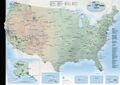
File:US interstate system.png [[Category:Maps]](640 × 402 (90 KB)) - 23:27, 18 February 2022
File:World Map - Mercator projection v Google maps.jpg :Google Maps (154 Million) :Apple Maps (23.3 M)(800 × 545 (101 KB)) - 18:37, 23 August 2020
File:Be a citizen scientist iNaturalist.png [[Category:Maps]](645 × 354 (217 KB)) - 21:09, 5 June 2018


