File:Drought Monitor Map - April 2022.png
Drought_Monitor_Map_-_April_2022.png (800 × 459 pixels, file size: 238 KB, MIME type: image/png)
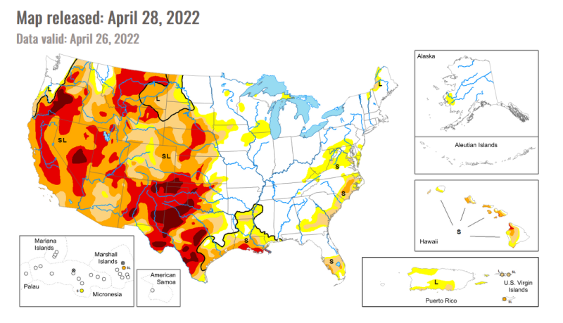
Drought Monitor Map - U.S. - April 2022
- Historic Drought Across the U.S. West
Six states are entirely in drought conditions. Across the US, the drought has nearly doubled in size from this time last year. Around 25% of the country was in drought conditions in July 2020; as of this week, nearly half is in drought.week, nearly half is in drought.
More than 25 percent of the West is in an exceptional drought, which is the most severe category used by the US Drought Monitor.(US Drought Monitor/CNN)
Climate change is playing a key role in these compounding crises: Drought and extreme heat are fueling wildfires; reduced snow pack and the lack of substantial extreme heat are fueling wildfires; reduced snow pack and the lack of substantial precipitation are exacerbating water demands for millions of people, as well as precipitation are exacerbating water demands for millions of people, as well as agriculture, ecosystems and deteriorating infrastructure.agriculture, ecosystems and deteriorating infrastructure.
~
File history
Click on a date/time to view the file as it appeared at that time.
| Date/Time | Thumbnail | Dimensions | User | Comment | |
|---|---|---|---|---|---|
| current | 18:40, 28 April 2022 | | 800 × 459 (238 KB) | Siterunner (talk | contribs) |
You cannot overwrite this file.
File usage
The following page uses this file:
- Agriculture
- Aquifers
- Clean Water
- Climate Change
- Climate Policy
- Desertification
- Earth Law
- Earth Observations
- Earth Science
- Earth Science from Space
- Ecology Studies
- Environmental Full-cost Accounting
- Environmental Security
- Environmental Security, National Security
- Externalities
- Farm-Related Policies
- Food
- Food-Related Policies
- Global Warming
- Green Politics
- Land Ethic
- Natural Capital
- Permaculture
- Planet Citizen
- Planet Citizens
- Planet Citizens, Planet Scientists
- Rivers
- Sustainability
- Sustainability Policies
- United Nations
- Urban Gardening
- Water
- Water Saving
- Wetlands
- Whole Earth