File:Virginia Norwood - 1948.jpg: Difference between revisions
Siterunner (talk | contribs) No edit summary |
Siterunner (talk | contribs) No edit summary |
||
| Line 34: | Line 34: | ||
Here we focus on the amazing story of Virginia Tower Norwood who invented technology that made LANDSAT's digital spectral imaging possible. In many ways, while inventing and convincing the reluctant aerospace men around her that digital imaging was the way to go, she was also continuing to be a first mover, graduating from MIT and creating a path of success for a next generation of women as scientists and engineers who would change the world. | Here we focus on the amazing story of Virginia Tower Norwood who invented technology that made LANDSAT's digital spectral imaging possible. In many ways, while inventing and convincing the reluctant aerospace men around her that digital imaging was the way to go, she was also continuing to be a first mover, graduating from MIT and creating a path of success for a next generation of women as scientists and engineers who would change the world. | ||
The following excerpt from the MIT June magazine cover story shows us what went into the first LANDSAT mission -- an ongoing earth imaging and research data bank that is now going on fifty plus years. LANDSAT 9 is about to be launched and the open source archive of digital multispectral imagery is an unprecedented and unequaled font of knowledge tracking changes of Earth's systems and resources over time, a scientific treasure. | The following excerpt from the MIT June magazine cover story shows us what went into the first LANDSAT mission -- an ongoing earth imaging and research data bank that is now going on fifty plus years. | ||
'''LANDSAT 9 is about to be launched and the open source archive of digital multispectral imagery is an unprecedented and unequaled font of knowledge tracking changes of Earth's systems and resources over time, a scientific treasure.''' | |||
| Line 41: | Line 43: | ||
<big><big>'''Multispectral Imagery'''</big></big> | |||
[[File:Landsat band imagery.png]] | |||
🌎 | |||
<big><big>'''Landsat, #PlanetCitizens, #PlanetScientists'''</big></big> | |||
'''Beginning with Visionaries in the 1960s''' | |||
'''New Visions of Earth Imaging -- a Half Century of Earth Observations, Earth Science, Environmental Protection''' | |||
* https://arstechnica.com/science/2021/09/new-nasa-satellite-to-continue-half-a-century-of-changing-earth-observations/ | |||
| |||
[[File:NASA Launch of Landsat 9 - Sept 27, 2021.jpg]] | |||
| |||
[[File:Landsat memories.png]] | |||
| |||
[[File:Landsat 9 about to launch.png]] | |||
[[Category:Anthropocene]] | |||
[[Category:Atmospheric Science]] | |||
[[Category:Earth Imaging]] | [[Category:Earth Imaging]] | ||
[[Category:Earth Science]] | [[Category:Earth Science]] | ||
[[Category:Earth Science from Space]] | [[Category:Earth Science from Space]] | ||
[[Category:Environmental Protection]] | [[Category:Environmental Protection]] | ||
[[Category:Environmental Security]] | |||
[[Category:Green Graphics]] | [[Category:Green Graphics]] | ||
[[Category:Land Use]] | |||
[[Category:Maps]] | [[Category:Maps]] | ||
[[Category:NASA]] | [[Category:NASA]] | ||
[[Category:Natural Resources]] | [[Category:Natural Resources]] | ||
[[Category:New Definitions of National Security]] | |||
[[Category:Planet Citizen]] | |||
[[Category:Planet Citizens]] | |||
[[Category:Planet Citizens, Planet Scientists]] | [[Category:Planet Citizens, Planet Scientists]] | ||
[[Category:Planet Scientists]] | |||
[[Category:Strategic Demands]] | |||
[[Category:Whole Earth]] | [[Category:Whole Earth]] | ||
Revision as of 19:35, 27 September 2021
LANDSAT and Virginia Tower Norwood
·····················································
Pioneering Earth Science
Virginia Tower Norwood: Planet Citizen, Earth Science Hero
Landsat was a model for all the following earth science research missions from space and is now moving into its fifth decade with Landsat 9.
Virginia Tower Norwood's Vision
Here we focus on the amazing story of Virginia Tower Norwood who invented technology that made LANDSAT's digital spectral imaging possible. In many ways, while inventing and convincing the reluctant aerospace men around her that digital imaging was the way to go, she was also continuing to be a first mover, graduating from MIT and creating a path of success for a next generation of women as scientists and engineers who would change the world.
The following excerpt from the MIT June magazine cover story shows us what went into the first LANDSAT mission -- an ongoing earth imaging and research data bank that is now going on fifty plus years.
LANDSAT 9 is about to be launched and the open source archive of digital multispectral imagery is an unprecedented and unequaled font of knowledge tracking changes of Earth's systems and resources over time, a scientific treasure.

Multispectral Imagery

🌎
Landsat, #PlanetCitizens, #PlanetScientists
Beginning with Visionaries in the 1960s
New Visions of Earth Imaging -- a Half Century of Earth Observations, Earth Science, Environmental Protection


File history
Click on a date/time to view the file as it appeared at that time.
| Date/Time | Thumbnail | Dimensions | User | Comment | |
|---|---|---|---|---|---|
| current | 17:38, 15 September 2021 | 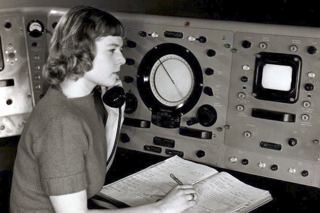 | 640 × 426 (74 KB) | Siterunner (talk | contribs) |
You cannot overwrite this file.
File usage
The following 4 pages use this file:
- Anthropocene
- Atmospheric Science
- Earth Imaging
- Earth Science
- Earth Science from Space
- Environmental Protection
- Environmental Security
- Green Graphics
- Land Use
- Maps
- NASA
- Natural Resources
- New Definitions of National Security
- Planet Citizen
- Planet Citizens
- Planet Citizens, Planet Scientists
- Planet Scientists
- Strategic Demands
- Whole Earth