File:Landsat band imagery.png: Difference between revisions
Siterunner (talk | contribs) No edit summary |
Siterunner (talk | contribs) No edit summary |
||
| Line 63: | Line 63: | ||
[[Category:Earth Observations]] | [[Category:Earth Observations]] | ||
[[Category:Earth Science]] | [[Category:Earth Science]] | ||
[[Category:Ecology Studies]] | |||
[[Category:Green Graphics]] | [[Category:Green Graphics]] | ||
[[Category:NanoRacks]] | [[Category:NanoRacks]] | ||
| Line 70: | Line 71: | ||
[[Category:Planet Citizens, Planet Scientists]] | [[Category:Planet Citizens, Planet Scientists]] | ||
[[Category:PlanetLabs]] | [[Category:PlanetLabs]] | ||
[[Category: | [[Category:Wetlands]] | ||
[[Category:Atmospheric Science]] | [[Category:Atmospheric Science]] | ||
Latest revision as of 01:59, 27 November 2022
Landsat
Inventing multispectral imaging of Earth
Creating earth science observations from space
LANDSAT and Virginia Tower Norwood
Virginia Tower Norwood: Planet Citizen, Earth Science Hero
Landsat was a model for all the following earth science research missions from space and is now moving into its fifth decade with Landsat 9.
Virginia Tower Norwood's Vision
Here we focus on the amazing story of Virginia Tower Norwood who invented technology that made LANDSAT's digital spectral imaging possible. In many ways, while inventing and convincing the reluctant aerospace men around her that digital imaging was the way to go, she was also continuing to be a first mover, graduating from MIT and creating a path of success for a next generation of women as scientists and engineers who would change the world.
The following excerpt from the MIT June magazine cover story shows us what went into the first LANDSAT mission -- an ongoing earth imaging and research data bank that is now going on fifty plus years. LANDSAT 9 is about to be launched and the open source archive of digital multispectral imagery is an unprecedented and unequaled font of knowledge tracking changes of Earth's systems and resources over time, a scientific treasure.
(At the beginning of Virginia's career - 1948)

The woman who brought us the world
Via MIT Technology Review
A half-century ago, Virginia Tower Norwood, MIT 1947, invented the first multispectral scanner to image Earth from space. Landsat 1 and its successors have been scanning the planet continuously ever since.
○
File history
Click on a date/time to view the file as it appeared at that time.
| Date/Time | Thumbnail | Dimensions | User | Comment | |
|---|---|---|---|---|---|
| current | 20:50, 26 September 2021 |  | 800 × 400 (907 KB) | Siterunner (talk | contribs) | |
| 02:59, 25 June 2015 | 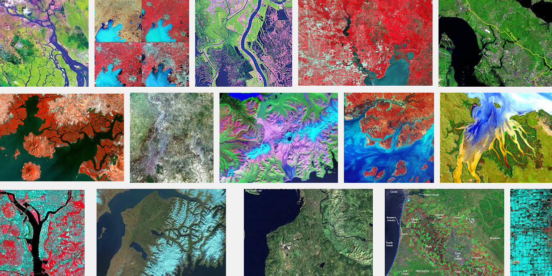 | 1,109 × 554 (1.41 MB) | Siterunner (talk | contribs) | Category:Democratization of Space Category:Earth Observations Category:Earth Science Category:Green Graphics Category:NanoRacks Category:New Space Category:Planet API Category:Planet Citizen [[Category:Planet Citizens, P... |
You cannot overwrite this file.
File usage
The following file is a duplicate of this file (more details):
The following 11 pages use this file:
- Climate News
- Climate News Events Archive ... 1970 to Today
- Earth Science Research from Space
- Earth and Space, Politics
- GreenPolicy360 Archive Highlights 2021
- Green Stories of the Day - GreenPolicy360 Archive
- LANDSAT and Virginia Tower Norwood
- File:Jerry Brown AGU-Dec14,2016.png
- File:Landsat, a 50 year legacy.png
- File:Landsat launched 50 years ago today.png
- File:Virginia Norwood - 1948.jpg
- Democratization of Space
- Earth Art
- Earth Observations
- Earth Science
- Ecology Studies
- Green Graphics
- NanoRacks
- New Space
- Planet API
- Planet Citizen
- Planet Citizens, Planet Scientists
- PlanetLabs
- Wetlands
- Atmospheric Science
- Biogeosciences
- Climate Change
- Planetary Science
- Space Science and Space Physics
- Earth360
- EarthPOV
- Whole Earth