File:Aquifers earthsciencefromspace Grace CA3.png

Original file (772 × 652 pixels, file size: 559 KB, MIME type: image/png)
http://touch.latimes.com/#section/-1/article/p2p-83799955/
http://www.jpl.nasa.gov/news/news.php?feature=4626
http://www.nzherald.co.nz/world/news/article.cfm?c_id=2&objectid=11466534
http://mashable.com/2015/06/16/groundwater-aquifers-depleted/
June 2015
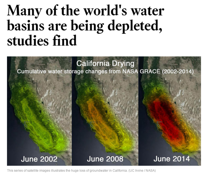
More than a third of the largest groundwater basins in the world are being depleted faster than they are getting replenished, and there are little to no accurate data showing just how much water is left in them, according to two new studies published Tuesday.
Researchers used data from NASA satellites to examine the 37 largest aquifers in the world. They found that eight were being depleted with almost no natural replenishment and five, including the Central Valley, were "extremely" or "highly stressed," with not enough water flowing back to offset how much is sucked up. Saudi Arabia, India, Pakistan and northern Africa have the most stressed aquifers, according to the research.
"We know we're taking more than we're putting back in — how long do we have before we can't do that anymore?"
File history
Click on a date/time to view the file as it appeared at that time.
| Date/Time | Thumbnail | Dimensions | User | Comment | |
|---|---|---|---|---|---|
| current | 13:36, 17 June 2015 | | 772 × 652 (559 KB) | Siterunner (talk | contribs) | http://touch.latimes.com/#section/-1/article/p2p-83799955/ Category:Green Graphics |
You cannot overwrite this file.
File usage
The following page uses this file:
- Aquifers
- Citizen Science
- Climate Change
- Earth360
- Earth Observations
- Earth Science
- Earth Science from Space
- Environmental Security
- Environmental Security, National Security
- EOS eco Operating System
- Geophysics and Geochemistry
- Geology
- Geophysics
- Green Graphics
- Hydrology
- Natural Resources
- Permaculture
- Planet API
- Planet Citizen
- Planet Scientist
- Planet Citizens, Planet Scientists
- Planetary Science
- Sustainability
- Sustainability Policies
- Virtual Earth
- Virtual Planet
- Water
- Whole Earth