Category:Wetlands
Wetlands and related terms:
https://en.wikipedia.org/wiki/Wetland
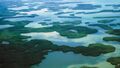
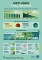
A wetland is a land area that is saturated with water, either permanently or seasonally, such that it takes on the characteristics of a distinct ecosystem. The primary factor that distinguishes wetlands from other land forms or water bodies is the characteristic vegetation of aquatic plants, adapted to the unique hydric soil. Wetlands play a number of roles in the environment, principally water purification, flood control, carbon sink and shoreline stability. Wetlands are also considered the most biologically diverse of all ecosystems, serving as home to a wide range of plant and animal life. Wetlands occur naturally on every continent except Antarctica, the largest including the Amazon River basin, the West Siberian Plain, and the Pantanal in South America. The water found in wetlands can be freshwater, brackish, or saltwater. The main wetland types include swamps, marshes, bogs, and fens; and sub-types include mangrove, carr, pocosin, and varzea.
The UN Millennium Ecosystem Assessment determined that environmental degradation is more prominent within wetland systems than any other ecosystem on Earth.
○ ○ ○ ○ ○ ○ ○ ○ ○ ○ ○ ○ ○ ○ ○ ○ ○ ○ ○
Estuary
https://en.wikipedia.org/wiki/Estuary
The word "estuary" is derived from the Latin word aestuarium meaning tidal inlet of the sea, which in itself is derived from the term aestus, meaning tide. There have been many definitions proposed to describe an estuary. The most widely accepted definition is: "a semi-enclosed coastal body of water, which has a free connection with the open sea, and within sea water is measurably diluted with freshwater derived from land drainage". However, this definition excludes a number of coastal water bodies such as coastal lagoons and brackish seas. A more comprehensive definition of an estuary is "a semi-enclosed body of water connected to the sea as far as the tidal limit or the salt intrusion limit and receiving freshwater runoff; however the freshwater inflow may not be perennial, the connection to the sea may be closed for part of the year and tidal influence may be negligible". This broad definition also includes fjords, lagoons, river mouths, and tidal creeks. An estuary is a dynamic ecosystem with a connection with the open sea through which the sea water enters with the rhythm of the tides. The sea water entering the estuary is diluted by the fresh water flowing from rivers and streams. The pattern of dilution varies between different estuaries and depends on the volume of fresh water, the tidal range, and the extent of evaporation of the water in the estuary.
Phytoplankton are key primary producers in estuaries.
Of the thirty-two largest cities in the world, twenty-two are located on estuaries. For example, New York City is located at the mouth of the Hudson River estuary.
As ecosystems, estuaries are under threat from human activities such as pollution and overfishing. They are also threatened by sewage, coastal settlement, land clearance and much more. Estuaries are affected by events far upstream, and concentrate materials such as pollutants and sediments. Land run-off and industrial, agricultural, and domestic waste enter rivers and are discharged into estuaries. Contaminants can be introduced which do not disintegrate rapidly in the marine environment, such as plastics, pesticides, furans, dioxins, phenols and heavy metals.
Such toxins can accumulate in the tissues of many species of aquatic life in a process called bioaccumulation. They also accumulate in benthic environments, such as estuaries and bay muds: a geological record of human activities of the last century.
For example, Chinese and Russian industrial pollution, such as phenols and heavy metals, has devastated fish stocks...
○ ○ ○ ○ ○ ○ ○ ○ ○ ○ ○ ○ ○ ○ ○ ○ ○ ○ ○ ○ ○ ○ ○ ○ ○ ○ ○ ○ ○ ○ ○ ○ ○ ○ ○ ○
What are wetlands -- as defined by the US Environmental Protection Agency
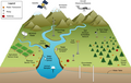
Wetlands are part of the foundation of our nation's water resources and are vital to the health of waterways and communities that are downstream. Wetlands feed downstream waters, trap floodwaters, recharge groundwater supplies, remove pollution, and provide fish and wildlife habitat. Wetlands are also economic drivers because of their key role in fishing, hunting, agriculture and recreation.
Wetlands include swamps, marshes and bogs. Wetlands vary widely because of differences in soils, topography, climate, hydrology, water chemistry, vegetation, and other factors.
Wetlands are often found alongside waterways and in flood plains. However, some wetlands have no apparent connection to surface water like rivers, lakes or the ocean, but have critical groundwater connections.
○ ○ ○ ○ ○ ○ ○ ○ ○ ○
What is an estuary -- as defined by the US Environmental Protection Agency
An estuary is a partially enclosed body of water along the coast where freshwater from rivers and streams meets and mixes with salt water from the ocean. Estuaries and the lands surrounding them are places of transition from land to sea and freshwater to salt water. Although influenced by the tides, they are protected from the full force of ocean waves, winds, and storms by such land forms as barrier islands or peninsulas.
Estuarine environments are among the most productive on earth, creating more organic matter each year than comparably-sized areas of forest, grassland, or agricultural land.
The tidal, sheltered waters of estuaries also support unique communities of plants and animals especially adapted for life at the margin of the sea.
Many different habitat types are found in and around estuaries, including shallow open waters, freshwater and salt marshes, swamps, sandy beaches, mud and sand flats, rocky shores, oyster reefs, mangrove forests, river deltas, tidal pools, and seagrasses.
○ ○ ○ ○ ○ ○ ○ ○ ○ ○ ○ ○ ○ ○ ○ ○ ○
- Marine and Coastal Zone wetlands
- Marine waters—permanent shallow waters less than six metres deep at low tide; includes sea bays, straits
- Subtidal aquatic beds; includes kelp beds, seagrasses, tropical marine meadows
- Coral reefs
- Rocky marine shores; includes rocky offshore islands, sea cliffs
- Sand, shingle or pebble beaches; includes sand bars, spits, sandy islets
- Intertidal mud, sand or salt flats
- Intertidal marshes; includes saltmarshes, salt meadows, saltings, raised salt marshes, tidal brackish and freshwater marshes
- Intertidal forested wetlands; includes mangrove swamps, nipa swamps, tidal freshwater swamp forests
- Brackish to saline lagoons and marshes with one or more relatively narrow connections with the sea
- Freshwater lagoons and marshes in the coastal zone
- Non-tidal freshwater forested wetlands
- Inland wetlands
- Permanent rivers and streams; includes waterfalls
- Seasonal and irregular rivers and streams
- Inland deltas (permanent)
- Riverine floodplains; includes river flats, flooded river basins, seasonally flooded grassland, savanna and palm savanna
- Permanent freshwater lakes (> 8 ha); includes large oxbow lakes
- Seasonal/intermittent freshwater lakes (> 8 ha), floodplain lakes
- Permanent saline/brackish lakes
- Seasonal/intermittent saline lakes
- Permanent freshwater ponds (< 8 ha), marshes and swamps on inorganic soils; with emergent vegetation waterlogged for at least most of the growing season
- Seasonal/intermittent freshwater ponds and marshes on inorganic soils; includes sloughs, potholes; seasonally flooded meadows, sedge marshes
- Permanent saline/brackish marshes
- Seasonal saline marshes
- Shrub swamps; shrub-dominated freshwater marsh, shrub carr, alder thicket on inorganic soils
- Freshwater swamp forest; seasonally flooded forest, wooded swamps; on inorganic soils
- Peatlands; forest, shrub or open bogs
- Alpine and tundra wetlands; includes alpine meadows, tundra pools, temporary waters from snow melt
- Freshwater springs, oases and rock pools
- Geothermal wetlands
- Inland, subterranean karst wetlands
- Human-made wetlands
- Water storage areas; reservoirs, barrages, hydro-electric dams, impoundments (generally > 8 ha)
- Ponds, including farm ponds, stock ponds, small tanks (generally < 8 ha)
- Aquaculture ponds; fish ponds, shrimp ponds
- Salt exploitation; salt pans, salines
- Excavations; gravel pits, borrow pits, mining pools
- Wastewater treatment; sewage farms, settling ponds, oxidation basins
- Irrigated land and irrigation channels; rice fields, canals, ditches
- Seasonally flooded arable land, farm land
Subcategories
This category has the following 7 subcategories, out of 7 total.
A
B
C
E
W
Pages in category "Wetlands"
The following 38 pages are in this category, out of 38 total.
A
C
- Cambridge, MA Resolution on Watershed Protection
- Climate News
- Climate News Events Archive ... 1970 to Today
- Colorado State University Wetlands
- Convention on Wetlands of International Importance, especially as Waterfowl Habitat
- Cornell University, NY Stormwater Management Wetland Demonstration Project
- Cornell University, NY Wetlands Creation
F
P
Media in category "Wetlands"
The following 103 files are in this category, out of 103 total.
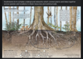
 A root and its mycorrhizal fungus surroundings.PNG 315 × 382; 236 KB
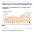
 A scorching year, what about the 360 warming data.jpg 600 × 706; 106 KB
 AB 2480 Meadows and Forest Water Infrastructure.png 481 × 375; 248 KB
 About Baselines and Change.png 592 × 312; 33 KB
 About website of The Invading Sea.png 800 × 343; 126 KB
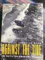 Against the Tide by Cornelia Dean.jpg 600 × 800; 265 KB
 Bill Mollison 1928-2016.pdf ; 99 KB
 Bill Mollison courtesy of Permaculture magazine.jpg 460 × 300; 0 bytes
 Bill Mollison the day after his passing memories.png 1,381 × 651; 1.65 MB
 Bill Nye The Planet's on Fire.jpg 800 × 675; 106 KB
 California's kelp forests and coastal biodiversity diminished.png 532 × 754; 307 KB
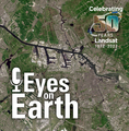 Celebrating 50 Years of Landsat.png 600 × 610; 909 KB
 Climate News Dec 4 2023 in Dubai.png 800 × 1,037; 649 KB
 Climate Plans Enforcement - Resources - GreenPolicy.png 768 × 897; 686 KB
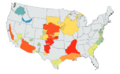
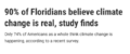 Climate poll - Florida.png 640 × 267; 36 KB
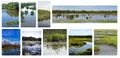 Coastal Intercoastal Wetlands.jpg 591 × 286; 55 KB
 COP28 News - Dec 13 2023.png 800 × 898; 410 KB
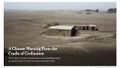 Cradle of Civilization - and climate change.jpg 640 × 360; 70 KB
 Discovery Center, St Pete Pier, Living Shorelines.jpg 800 × 530; 118 KB
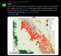
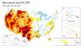 Drought Monitor Map - April 2022.png 800 × 459; 238 KB
 Earths-Future .jpg 351 × 198; 41 KB
 Earths-Future-cover.jpg 251 × 325; 48 KB
 EarthScience Missions via the EOS - 2022.png 800 × 219; 139 KB
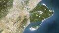 Ebro Delta, Spain.jpg 624 × 351; 52 KB
 Environmental Protection Agency logo.png 380 × 414; 39 KB
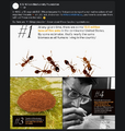 EO and Fire Ants in the US - on World Wildlife Day.png 768 × 811; 663 KB
 EO Snapshot 6-29-2016 10-44-49 AM.png 839 × 768; 907 KB
 ESG Fight - Feb 2023.png 396 × 194; 88 KB
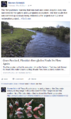
 Estuary in Clearwater on Tampa Bay.jpg 3,584 × 2,016; 1.5 MB
 Eukaryotic Cell SCU.jpg 716 × 1,024; 799 KB
 Everglades restoration 2016 update.png 485 × 813; 356 KB
 Fire Ants.png 601 × 600; 603 KB
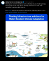 Floating adaptations - GCA - for sea-level rise - circa 2023.png 600 × 732; 273 KB
 Florida rights of nature lawsuit - May 2021.jpg 527 × 806; 179 KB
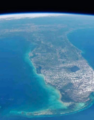 Florida via NASA 2022.png 800 × 1,020; 1.12 MB
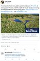
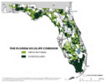 Florida Wildlife Corridor - 2022 illustration.png 800 × 628; 473 KB
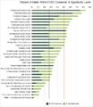 Florida Wildlife Corridor FLWC Water Benefits December 2022.png 768 × 886; 109 KB
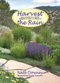 Harvest the Rain cover .png 582 × 800; 1.06 MB
 Harvest the Rain reviews.png 800 × 879; 306 KB
 Hindu Kush-Himalayas - 2023 Report on Dangerous Climate Impacts.png 800 × 819; 1,023 KB
 Huge heat anomaly in 2023 - by Gavin Schmidt.png 735 × 857; 172 KB
 Kenny Ausubel quote.jpeg 415 × 163; 46 KB
 Land Remote Sensing Policy Act of 1992.jpg 563 × 480; 144 KB
 Landsat band imagery.png 800 × 400; 907 KB
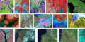 Landsat band imagery2.png 800 × 400; 907 KB
 Landsat data site.png 657 × 600; 499 KB
 Landsat launched 50 years ago today.png 528 × 779; 755 KB
 Landsat NASA - Feb 11 2023.png 763 × 600; 578 KB
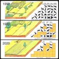
 Landsat US collection of maps 1985-2021.png 768 × 775; 1,018 KB
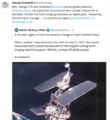 Landsat, a 50 year legacy.png 528 × 575; 288 KB
 Living Earth.png 441 × 183; 106 KB
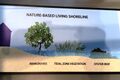
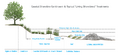 Living-Shoreline.png 800 × 367; 128 KB
 LivingShorelines Graph.png 680 × 375; 73 KB
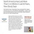 Loss of N American Birds - 1.jpg 800 × 788; 173 KB
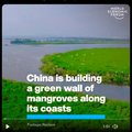 Mangroves 'green wall' in China.png 600 × 600; 466 KB
 Mangroves and Coastal Wetlands tracked by Landsat.png 600 × 716; 245 KB
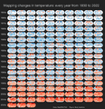 Mapping changes in global temperature 1850-2022.png 656 × 680; 180 KB
 Mushroom life in the forest.png 640 × 458; 626 KB
 NOAA - NCEI report on US temps 2023-2024.jpg 600 × 561; 109 KB
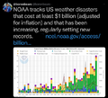 NOAA extreme weather events charting.png 663 × 600; 288 KB
 NOAA report on heat records broken in US - 2023.jpg 600 × 480; 229 KB
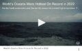 Oceans hottest in 2022.png 800 × 501; 358 KB
 Our Fragile Moment.jpg 612 × 480; 80 KB
 Our Fragile Moment.png 301 × 448; 360 KB
 Permaculture-observation tip.jpg 480 × 540; 86 KB
 Planet Dove satellite image over Dubai.png 800 × 791; 1.58 MB
 Protect the Natural World.jpg 800 × 345; 78 KB
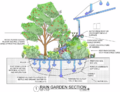 Rain Garden Design courtesy of www.PermaDesign.com Nate Downey.png 800 × 614; 601 KB
 Record tumble - climate change.png 727 × 333; 27 KB
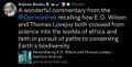 Remembering E.O. Wilson and Thomas Lovejoy.jpg 640 × 327; 56 KB
 Republican Party 2024 Climate Strategy.png 589 × 344; 44 KB
 River basins - watersheds.jpg 800 × 214; 111 KB
 Sea levels surge along southern US coast.png 640 × 441; 69 KB
 Seeds of Change, published 1994.png 628 × 763; 915 KB
 Seeds of Change.jpg 260 × 346; 27 KB
 Shell lawsuit Feb 2023.png 768 × 534; 229 KB
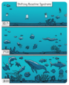 Shifting Baseline Syndrome - threats to ecosystems biodiversity.png 431 × 534; 322 KB
 Shifting Baselines 2.jpg 600 × 600; 140 KB
 Tardi1.jpg 470 × 264; 28 KB
 Telling stories of solutions for the climate crisis.jpg 600 × 640; 121 KB
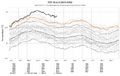 Temperature - SST World via Climate Change Institute - 2023 chart.png 800 × 509; 144 KB
 Temperature World - chart via Climate Change Institute.jpg 800 × 509; 67 KB
 Ten thousand islands -- Marco island.jpg 640 × 360; 30 KB
 The Daily Puffin.png 768 × 800; 766 KB
 The Hidden Universe - Adventures in Biodiversity.png 768 × 959; 365 KB
 Toby Hemenway-RIP Dec2016.png 503 × 327; 32 KB
 Tree of Life nmicrobiol201648-f1 via Nature.jpg 695 × 833; 98 KB
 Tree of Life on Hand.jpg 336 × 448; 70 KB
 Update - James Hansen July 2023 'We are fools'.png 595 × 800; 610 KB
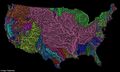 US River basins - watersheds.jpg 800 × 477; 131 KB
 USGS Groundwater depletion map 2013.png 794 × 490; 238 KB
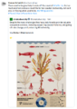
 Value the Wetlands - UN Biodiversity Infographic 2023.jpg 633 × 900; 110 KB
 Water Action News - March 2023.png 640 × 277; 103 KB
 WaterAction - 2023.PNG 480 × 640; 300 KB
 Watershed monitoring earthscience m.png 572 × 360; 143 KB
 Wetlands - Wetlands Day.png 640 × 492; 333 KB
 Who really invented the climate stripes - Climate Change Education.png 600 × 600; 234 KB
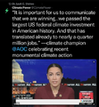 Winning on the climate legis - AOC.png 480 × 519; 249 KB


