Category:Maps: Difference between revisions
Siterunner (talk | contribs) |
Siterunner (talk | contribs) No edit summary |
||
| Line 38: | Line 38: | ||
[[File:Virtual Earth cover.png]] | [[File:Virtual Earth cover.png]] | ||
| |||
| |||
[[Image:Map-Marker-Marker-free.png]] | [[Image:Map-Marker-Marker-free.png]] | ||
| |||
Revision as of 20:34, 27 August 2018
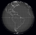
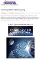
Virtual Earth Mapping
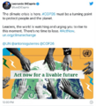
How Facebook, Apple and Microsoft are contributing to an openly licensed map of the world
Collaborating in the open to build an openly licensed map of the world: OpenStreetMap
August 2018
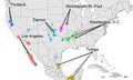
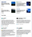
OpenStreetMap, launched in 2004, has grown into one of the most successful collaboratively maintained open datasets in the world. Today, contributors to the maps include not just keen local mappers, but also a diverse mix of commercial organisations, non-governmental organisations, humanitarian organisations and also large commercial organisations.
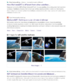
The Microsoft Open Maps team has recently released open data on building footprints in the US. Microsoft was among the first to release satellite imagery for use by OpenStreetMap and the images are now integrated into the default editor. It also has a community of mappers directly contributing to OpenStreetMap in Australia.
Apple has an internal volunteer programme that has around 5,000 staff contributing to Missing Maps, they’ve released building data for France and Denmark, and are engaged with data improvement projects around the world.
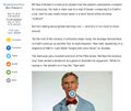
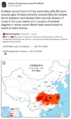
Facebook is exploring how artificial intelligence-assisted tracing can help to improve the quality of OpenStreetMap data in Thailand.
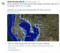
DigitalGlobe has made its satellite imagery available under a licence that will allow it to be used by the OpenStreetMap community to improve their mapping efforts.
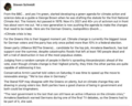
Telenav launched OpenStreetCam to help collect openly-licensed street imagery and has now released open data and code to explore how machine learning can enable the images to be used to improve OpenStreetMap with stop signs and turn directions.
More at StateoftheMap
○
Explore Mapping / Geographic Information Science at GreenPolicy's 'Virtual Earth


Maps to Guide You
○
○
○
Carto
○
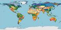
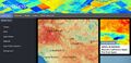
Global Ecological Land Units
http://ecoexplorer.arcgis.com/eco/maps.html
http://www.aag.org/global_ecosystems
http://www.aag.org/galleries/default-file/AAG_Global_Ecosyst_bklt300.pdf
http://www.wired.com/2015/02/new-map-shows-worlds-ecosystems-unprecedented-detail/
○
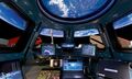
Where Are You?
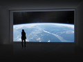
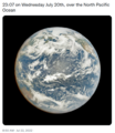
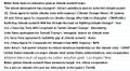
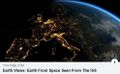
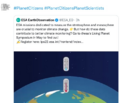
Where Are You? Pictures of Us from the International Space Station
What Are Your 'Coordinates', the Space Station Will Send You a Photo -- Pictures from ISS
Subcategories
This category has the following 18 subcategories, out of 18 total.
A
E
F
G
L
N
O
P
S
T
U
V
Pages in category "Maps"
The following 57 pages are in this category, out of 57 total.
C
E
G
- George E. Brown Jr
- Glasgow Climate Summit - Pledges, Promises, Declarations - What's Next Up
- Global Climate Action Summit
- Global Fishing Watch
- Going Green
- Google Earth
- Google Earth Timelapse
- Green New Deal
- Green Quotes
- Green Stories of the Day
- Green Stories of the Day - GreenPolicy360 Archive
- GreenLinks
- GreenPolicy360 Archive Highlights 2013
- GreenPolicy360 Archive Highlights 2014
- GreenPolicy360 Archive Highlights 2015
- GreenPolicy360 Archive Highlights 2016
- GreenPolicy360 Archive Highlights 2017
- GreenPolicy360 Archive Highlights 2018
- GreenPolicy360 Archive Highlights 2019
- GreenPolicy360 Archive Highlights 2020
- GreenPolicy360 Archive Highlights 2023
P
T
Media in category "Maps"
The following 200 files are in this category, out of 528 total.
(previous page) (next page)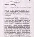 1977 from the Office of Science and Technology Policy.jpg 661 × 711; 177 KB
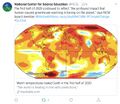
 2020 record temperatures.png 800 × 502; 358 KB
 7-20-2020 GreenPolicy360 RT No.2.jpg 591 × 510; 125 KB
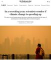 A scorching year, what about the 360 warming data.jpg 600 × 706; 106 KB
 About website of The Invading Sea.png 800 × 343; 126 KB
 Above.png 500 × 375; 173 KB
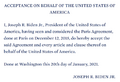 Acceptance on behalf of the United States of America.png 448 × 306; 62 KB
 Act now for a livable future.png 501 × 275; 272 KB
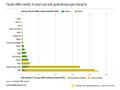 Ag production and GHG emissions.jpg 680 × 510; 33 KB
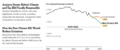
 Amazon fires burn across the rainforest.jpg 800 × 504; 76 KB
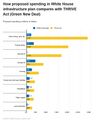 American Jobs Act compared w THRIVE Act (Green New Deal).jpg 674 × 798; 90 KB
 AOC re climate task force - july 8 2020.jpg 585 × 203; 38 KB
 ArcGIS-logo.png 302 × 167; 7 KB
 Arctic - Kolbert - 2023.png 553 × 476; 274 KB
 Arctic Melt - 1950-2020.png 640 × 349; 287 KB
 Arctic Siberia Heatwave - Again - June 2021.jpg 640 × 360; 83 KB
 Arctic-March30,2019.jpg 797 × 600; 126 KB
 Arctic-Siberia-6-20-2020.jpg 478 × 644; 148 KB
 Atmosphere Science.jpg 800 × 600; 45 KB
 Atmospheric Experiment of Humanity.jpg 519 × 574; 201 KB
 Attack from Within - by Barb McQuade.png 600 × 630; 222 KB
 AU Too Hot.png 640 × 413; 286 KB
 Banking - finance - climate - Mann-1.jpg 452 × 640; 162 KB
 Banking - finance - climate - Mann-2.jpg 452 × 640; 164 KB
 Battle for Democracy.jpg 640 × 123; 24 KB
 Be a citizen scientist iNaturalist.png 645 × 354; 217 KB
 Bernie Sanders, Senate 2.PNG 800 × 517; 379 KB
 Bernie Sanders, Senate Aug 3.PNG 800 × 518; 388 KB
 Biden - clean energy ambitions.JPG 640 × 334; 31 KB
 Biden introduces leadership team - Nov 24 2020.jpg 800 × 644; 173 KB
 Biden selects Kerry as special climate envoy.jpg 592 × 505; 87 KB
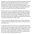
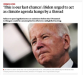 Biden urged to act - Oct 18 2021 - The Guardian.png 663 × 600; 497 KB
 Biden's assembled an all-star climate team 4-21-2021.jpg 682 × 732; 309 KB
 Biden-Sanders Unity Task Force on Climate.jpg 701 × 780; 139 KB
 Big Oil Rocked by News May 27 2021.jpg 639 × 600; 84 KB
 Big Wobble 2020.jpg 507 × 342; 79 KB
 Biggest climate related legislation in history - 1.png 800 × 188; 68 KB
 Bill McKibben switches gears-Sept 2021.jpg 518 × 265; 78 KB
 Bill Nelson on Global Temp Rise and Climate Change.png 640 × 353; 100 KB
 Bill Nye The Planet's on Fire.jpg 800 × 675; 106 KB
 Bioneers 2023 - ThirdAct.Org.jpg 624 × 600; 145 KB
 Bioneers Conf 2021- Buckminster Fuller Instit joins.png 469 × 586; 599 KB
 Bioneers It's all connected - 30th annual conference.jpg 527 × 521; 79 KB
 Bloomberg Carbon Clock 10-26-2021 8-47-05 AM EST.png 800 × 195; 356 KB
 Bloomberg Live Climate Data Dashboard.jpg 640 × 756; 156 KB
 Breakpoint - Reckoning with America's Environmental Crisis.jpg 329 × 500; 49 KB
 Burst of climate denial as Trump presidency ends.jpg 632 × 604; 92 KB
 Car heating and cooling.png 465 × 635; 261 KB
 Carbon Brief - Greenhouse gas levels 2021.png 640 × 436; 292 KB
 Caroline Lucas-Green New Deal.jpg 584 × 391; 71 KB
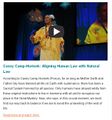 Casey Camp-Horinek.jpg 606 × 650; 132 KB
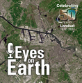 Celebrating 50 Years of Landsat.png 600 × 610; 909 KB
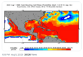
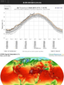 CFSV2 world temp July 3, 2023.png 600 × 800; 513 KB
 CH4 graph - 1980-2020.JPG 640 × 446; 22 KB
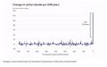 Changes in carbon dioxide per 1000 years - via Climate Central.jpg 682 × 424; 34 KB
 China Record Heat - August 2022.png 800 × 1,343; 812 KB
 Citizens Climate Lobby - Save Our Future Act 2021.jpg 518 × 262; 77 KB
 Citizens Climate Lobby - Tampa Bay.jpg 586 × 515; 125 KB
 Climate Action 25th conf in Madrid.jpg 680 × 510; 22 KB
 Climate action isn't 'bunny hugging' says Boris.jpg 800 × 264; 95 KB
 Climate activist - Steven Schmidt - 1978 on.png 600 × 480; 174 KB
 Climate Books - 2020.jpg 800 × 450; 69 KB
 Climate Change COP27 - Nov 11 2022 US Representatives.jpg 712 × 444; 54 KB
 Climate Change COP27 - Nov 11 Kathy Castor.jpg 712 × 710; 77 KB
 Climate Change US EPA.jpg 600 × 703; 95 KB
 Climate Conferences 1979-2020.jpg 768 × 768; 121 KB
 Climate Crisis - Emily Atkin Heated No. 1.jpg 537 × 453; 61 KB
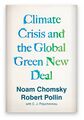 Climate Crisis and the Global Green New Deal.jpg 293 × 418; 33 KB
 Climate debate.jpg 493 × 580; 129 KB
 Climate Desk.jpg 390 × 226; 21 KB
 Climate diplomacy is failing - June 2020.jpg 592 × 440; 71 KB
 Climate Emergency Institute - Oct 2022.png 610 × 600; 274 KB
 Climate Emergency Institute -- 2021.jpg 800 × 450; 55 KB
 Climate emergency.jpg 800 × 450; 69 KB
 Climate Headline News around the World - July 2023.jpg 600 × 704; 151 KB
 Climate Models.png 639 × 558; 123 KB
 Climate News - Oct 28 2022.jpg 626 × 600; 88 KB
 Climate News - United Nations Report - Feb 2022.png 768 × 878; 539 KB
 Climate News Dec 4 2023 in Dubai.png 800 × 1,037; 649 KB
 Climate Plans Enforcement - Resources - GreenPolicy.png 768 × 897; 686 KB
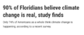 Climate poll - Florida.png 640 × 267; 36 KB
 Climate strike - Week 171.png 739 × 600; 834 KB
 Climate Strike Around the World - Sep20,2019.jpg 700 × 830; 119 KB
 Climate Summit - Leonardo DiCaprio.png 600 × 663; 521 KB
 Climate Summit live updates - Nov 2 2021.png 751 × 600; 420 KB
 Climate Summit planned-1.jpg 800 × 301; 53 KB
 Climate Summit planned-2.jpg 800 × 187; 31 KB
 Climate Summit planned-3.jpg 800 × 278; 44 KB
 Climate Summit planned-4.jpg 800 × 241; 41 KB
 Climate usa 60 years on.jpg 800 × 480; 34 KB
 ClimateNewsFlorida.jpg 448 × 191; 36 KB
 CO2 at Mauna Loa data - June 02, 2020 - 417.90 ppm.jpg 640 × 566; 66 KB
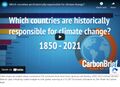 CO2 cumulative emissions 1850 - 2021 - countries.jpg 640 × 462; 211 KB
 CO2 emissions-around-the-world.png 800 × 595; 123 KB
 CO2 global pathways via IPCC AR6 - how will we respond.jpg 800 × 450; 57 KB
 COP26 Climate Summit concludes.jpg 600 × 800; 160 KB
 COP26 concludes - 2.png 648 × 467; 177 KB
 COP26 concludes - 3.png 648 × 713; 416 KB
 COP26 concludes.png 648 × 528; 329 KB
 COP26 in GLASGOW - 31 OCT-12 NOV 2021.jpg 800 × 264; 51 KB
 COP27 'opening speech'.png 640 × 460; 160 KB
 COP28 News - Dec 13 2023.png 800 × 898; 410 KB
 CopernicusEU - Sentinel5P Atmosphere Monitoring Mission - 2.jpg 795 × 1,477; 654 KB
 CopernicusEU - Sentinel5P Atmosphere Monitoring Mission.png 583 × 465; 222 KB
 Coral bleaching - August 2023.png 488 × 430; 261 KB
 Coral bleaching - NOAA - August 2023.png 488 × 338; 201 KB
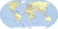 Countries Nations world map s.jpg 300 × 152; 16 KB
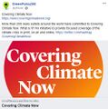 Covering Climate Now.jpg 493 × 498; 67 KB
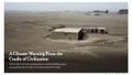 Cradle of Civilization - and climate change.jpg 640 × 360; 70 KB
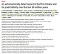 Dated record of Earths climate - Science Report Sept 10 2020.jpg 735 × 669; 192 KB
 Death Valley ... the heat, what its like.jpg 640 × 381; 62 KB
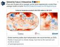 Defend Our Future 6-1-2020.jpg 585 × 458; 103 KB
 Democratic Climate Plan-Introduced June 2020.jpg 528 × 561; 117 KB
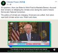 Democratic National Convention-62 climate speakers.jpg 443 × 407; 57 KB
 Democratic Party Climate Bill - Aug 2022.png 640 × 269; 70 KB
 Democratic Party pres candidates debate in Miami-June 2019.jpg 800 × 534; 124 KB
 Democratic presidential candidates on the Green New Deal.jpg 800 × 359; 57 KB
 Denying human-caused climate change.jpg 639 × 620; 129 KB
 Digital.png 427 × 116; 51 KB
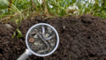 Dirt, soil, worms, good.png 700 × 399; 695 KB
 Don't Look Up ....jpg 430 × 543; 172 KB
 Don't Look Up.jpg 800 × 450; 104 KB
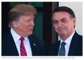 Donald Trump-Jair Bolsonaro-March 2019.jpg 640 × 455; 57 KB
 Dove1 image.jpg 420 × 308; 26 KB
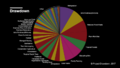
 Drawdown Climate action, climate solutions.png 800 × 695; 246 KB
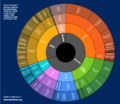
 Drawdown Solution Chart.png 800 × 450; 186 KB
 DSCOVR EPIC - July 20 2022.png 532 × 612; 315 KB
 Each of us can make a difference.png 521 × 474; 191 KB
 Earth AI - Feb 2022.png 482 × 480; 192 KB
 Earth Day 2021 - Climate Summit News-1.jpg 491 × 270; 127 KB
 Earth Day 50 years on.jpg 480 × 548; 107 KB
 Earth Information Center - 2022 Graphic NASA.png 800 × 981; 868 KB
 Earth Information Center from NASA.jpg 800 × 577; 94 KB
 Earth mapped.png 800 × 783; 254 KB
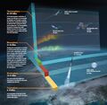
 Earth Observing System - fleet of satellites.png 740 × 576; 557 KB
 Earth POV from the ISS Cupola-m.jpg 800 × 480; 71 KB
 Earth Summit 1992-s.png 336 × 418; 283 KB
 Earth Summit 1992.jpg 600 × 746; 171 KB
 Earth System Observatory-1.jpg 580 × 833; 129 KB
 Earth System Observatory-2.jpg 580 × 831; 69 KB
 Earth trapping unprecedented amount of heat - NASA.jpg 468 × 373; 56 KB
 Earth Viewing from the International Space Station.jpg 496 × 307; 45 KB
 Earth visions.png 387 × 373; 231 KB
 Earth-NASA.jpg 800 × 265; 39 KB
 Earth-upper-atmosphere-NASA.jpg 800 × 781; 327 KB
 EarthDecadel Priorities-2018.jpg 779 × 529; 85 KB
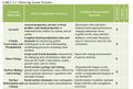
 EarthScience Missions via the EOS - 2022.png 800 × 219; 139 KB
 Ebird-mobile-apps.png 800 × 338; 166 KB
 Economist.com global capital snapshot as of July 2020.jpg 800 × 477; 119 KB
 Ecoregions of the World terrestrial-wiki.jpg 800 × 400; 33 KB
 Ecostress Mission-Aug 2020.jpg 640 × 311; 85 KB
 ECOTRAM - Don Perry.png 800 × 474; 390 KB
 EDF satellite - methane tracking.png 600 × 674; 388 KB
 Einstein - the whole of nature 1.PNG 444 × 619; 216 KB
 Einstein - the whole of nature 2.JPG 680 × 623; 110 KB
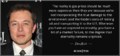 Elon Musk quote - gas externality price.png 680 × 320; 199 KB
 Energy Charter Treaty.jpg 512 × 480; 74 KB
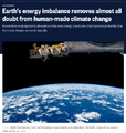 Energy Imbalance, Climate Change - Aug 1 2021.png 640 × 672; 394 KB
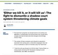
 Environmental laws in US - Supreme Court votes soon.png 800 × 414; 334 KB
 EO Snapshot 6-29-2016 10-44-49 AM.png 839 × 768; 907 KB
 EPA and the Green Bank - Feb 2023.png 476 × 542; 244 KB
 ERoadArlanda.png 800 × 495; 539 KB
 ESA Living Planet Symposium - Announcement.png 637 × 600; 508 KB
 ESA Living Planet Symposium - May 2022.png 700 × 600; 258 KB
 ESG Fight - Feb 2023.png 396 × 194; 88 KB
 ESRI logo.jpg 366 × 138; 10 KB
 Estuary in Clearwater on Tampa Bay.jpg 3,584 × 2,016; 1.5 MB
 EU agrees to cut emissions 55 percent by 2030.jpg 800 × 558; 96 KB
 EU unveils new climate change policy - July 14 2021 - 1.jpg 800 × 234; 33 KB
 EU unveils new climate change policy - July 14 2021 - 2.jpg 800 × 552; 86 KB
 EU unveils new climate change policy - July 14 2021 - 3.jpg 800 × 549; 89 KB
 EU unveils new climate change policy - July 14 2021 - 4.jpg 800 × 550; 92 KB
 EU unveils new climate change policy - July 14 2021 - 5.jpg 800 × 548; 88 KB
 EU unveils new climate change policy - July 14 2021 - 6.jpg 800 × 557; 89 KB
 EU unveils new climate change policy - July 14 2021 - 7.jpg 800 × 553; 92 KB
 EU unveils new climate change policy - July 14 2021 - 8.jpg 800 × 589; 91 KB
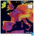 Europe heat wave - July 19 2022 - via Copernicus satellite.png 600 × 639; 704 KB
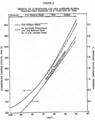 ExxonMobil CO2 climatic response study - Graphic 1 - 1982.png 537 × 680; 150 KB
 ExxonMobil CO2 climatic response study - Graphic 2 - 1982.png 537 × 605; 112 KB
 Fact Checking @GreenPolicy360.jpg 580 × 800; 206 KB
 Fact Checking organizations at work.jpg 800 × 390; 44 KB
 Facts Count-WaPo Reports-19127 false-misleading claims in 1226 days.jpg 601 × 489; 100 KB
 Fire incidents reporting - US Sept 2020.jpg 502 × 341; 71 KB
 Floating adaptations - GCA - for sea-level rise - circa 2023.png 600 × 732; 273 KB
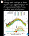 Florida Keys sea surface temps for 2023 (as of July).png 480 × 585; 287 KB
 Florida ocean water temp south of Everglades tops 99 F. degrees.png 480 × 564; 128 KB
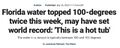 Florida sea surface water in the Keys area tops 100 degree F.jpg 640 × 257; 58 KB
 Free google maps pointer icon.jpg 425 × 369; 22 KB
 From 1968 to 1992 -- and the Journey continues....png 572 × 851; 320 KB
 G Earth Outreach.jpg 800 × 412; 44 KB
 Gavin in Glasgow - Nov 10 2021.png 728 × 600; 378 KB
 Geosciences satellite fields b.jpg 461 × 444; 186 KB
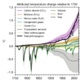 GHG forcings 1750-2020.png 531 × 531; 94 KB
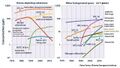 GHG ppt concentrations 1975-2020.jpg 640 × 361; 69 KB


.jpg)


.png)


