Category:Antarctica
2019
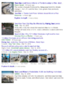
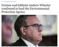
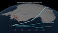
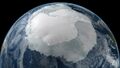
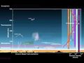
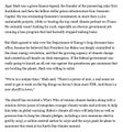
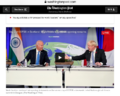
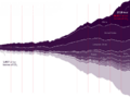
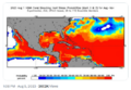
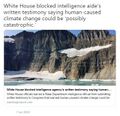
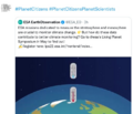
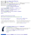
- Antarctica is losing ice 6 times faster today than in 1980s
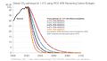
- Antarctic melting study... 'reasons for concern'

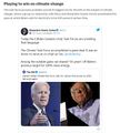
Read this research data thread and Antarctic sea-level rise connection from @chriscmooney, environmental reporter from the Washington Post:
- ·················································································································

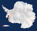
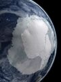
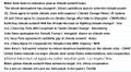
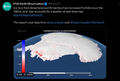
Scientists release the most accurate, high-resolution terrain map ever created (2018)
- The new Antarctic map shows a resolution of 2 to 8 meters – compared to the previous standard of 1,000 meters.
Reference Elevation Model of Antarctica / Release 1
Accurate Antarctica / Phys.org
Large-format poster map of the Reference Elevation Model of Antarctica (REMA), rendered with a hillshade. Does not include any cartographic elements.
http://maps.apps.pgc.umn.edu/id/2364
Large-format poster map of the Reference Elevation Model of Antarctica (REMA), rendered with a hillshade. Includes cartographic elements such as place name labels, graticules...
http://maps.apps.pgc.umn.edu/id/2365
Use the links below to browse the directory for the entire REMA dataset. Refer to Documentation to see the directory structure, naming schemes, and download contents.
HTTP: http://data.pgc.umn.edu/elev/dem/setsm/REMA
FTP: ftp://ftp.data.pgc.umn.edu/elev/dem/setsm/REMA
"Considering that Antarctica is the highest, driest, and one of the most remote places on Earth, we now have an incredible topographic model to measure against in the future," said Paul Morin, a University of Minnesota earth sciences researcher and the director of the Polar Geospatial Center.
"Up until now, we've had a better map of Mars than we've had of Antarctica," said Ian Howat, professor of earth sciences and director of the Byrd Polar and Climate Research Center at The Ohio State University. "Now it is the best-mapped continent on Earth."
"It is the highest-resolution terrain map by far of any continent,’ said Ian Howat, professor of Earth sciences and director of the Byrd Polar and Climate Research Center at The Ohio State University.
- ·······································································
- Antarctic Treaty System
- NASA IceBridge Antarctica
- Antarctica's Flowing Ice
····················································································
2018
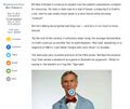
Antarctic Melt Needs to be Monitored More Closely
··········
2017
- How active are newly discovered Antarctic volcanoes?
- A new volcanic province: an inventory of subglacial volcanoes in West Antarctica
- ...the biggest cluster of volcanoes in the world.
The study, published in the Geological Society Special Publications series, does not indicate whether the volcanoes are active but the team is trying to find out.
As Dr. Robert Bingham, a glacier expert and one of the paper's authors noted to the Guardian, "The big question is: how active are these volcanoes?"
"That is something we need to determine as quickly as possible," Bingham continued. "Anything that causes the melting of ice—which an eruption certainly would—is likely to speed up the flow of ice into the sea."
Ominously, other experts have warned that a reverse situation could also happen — volcanic activity can be triggered by thinning ice sheets from rising global temperatures.

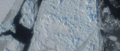
Trillion Ton Iceberg Breaks Off

- _____________________________________________________________________

- ___________________________________________________________
- The Future of the US Antarctica Station and Research

Subcategories
This category has the following 4 subcategories, out of 4 total.
C
E
S
Pages in category "Antarctica"
The following 31 pages are in this category, out of 31 total.
C
E
G
- Glasgow Climate Summit - Pledges, Promises, Declarations - What's Next Up
- Global Climate Action Summit
- Green Stories of the Day
- Green Stories of the Day - GreenPolicy360 Archive
- GreenPolicy360 Archive Highlights 2013
- GreenPolicy360 Archive Highlights 2014
- GreenPolicy360 Archive Highlights 2015
- GreenPolicy360 Archive Highlights 2016
- GreenPolicy360 Archive Highlights 2017
- GreenPolicy360 Archive Highlights 2018
- GreenPolicy360 Archive Highlights 2019
- GreenPolicy360 Archive Highlights 2020
- GreenPolicy360 Archive Highlights 2023
S
T
Media in category "Antarctica"
The following 200 files are in this category, out of 355 total.
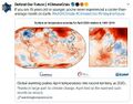
(previous page) (next page) 2020 record temperatures.png 800 × 502; 358 KB
 3-15-2016 12-29-07 PM.png 538 × 701; 201 KB
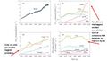
 5 19 14 andrew antarcticaelevationchanges-640x547.jpg 640 × 547; 59 KB
 7-20-2020 GreenPolicy360 RT No.2.jpg 591 × 510; 125 KB
 A scorching year, what about the 360 warming data.jpg 600 × 706; 106 KB
 Acceptance on behalf of the United States of America.png 448 × 306; 62 KB
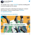
 Act now for a livable future.png 501 × 275; 272 KB
 Ag production and GHG emissions.jpg 680 × 510; 33 KB
 Against the Tide - Cover - by Cornelia Dean.jpg 308 × 475; 57 KB
 Air pollution moves globally.png 620 × 412; 256 KB
 Aldis zone blog.jpg 500 × 498; 67 KB
 Andrew Wheeler confirmed to head EPA.jpg 753 × 600; 85 KB
 Antarctic Ice Shelf June 2017.png 600 × 337; 142 KB
 Antarctic sea ice 1989-2023 chart as of July2023.png 640 × 433; 294 KB
 Antarctica from Blue Marble wiki.jpg 768 × 768; 133 KB
 Antarctica ice losses chart-NASA re study.jpg 800 × 450; 43 KB
 Antarctica ice shelf-glaciers 2012.png 956 × 714; 805 KB
 Antarctica NASA 1024x768.jpg 1,024 × 768; 250 KB
 Antarctica science - warming water, shrinking ice.png 640 × 356; 174 KB
 Antarctica-2016 nasa.jpg 1,600 × 900; 174 KB
 Antarctica-2018.jpg 768 × 1,024; 82 KB
 Arctic - Antarctic - Breaking.png 639 × 600; 903 KB
 Arctic Sea Ice Area graphic thru 2016.png 640 × 355; 382 KB
 Atmosphere Science.jpg 800 × 600; 45 KB
 Atmospheric Experiment of Humanity.jpg 519 × 574; 201 KB
 Banking - finance - climate - Mann-1.jpg 452 × 640; 162 KB
 Banking - finance - climate - Mann-2.jpg 452 × 640; 164 KB
 Battle for Democracy.jpg 640 × 123; 24 KB
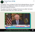
 Biden introduces leadership team - Nov 24 2020.jpg 800 × 644; 173 KB
 Biden selects Kerry as special climate envoy.jpg 592 × 505; 87 KB
 Biden's assembled an all-star climate team 4-21-2021.jpg 682 × 732; 309 KB
 Biden-Sanders Unity Task Force on Climate.jpg 701 × 780; 139 KB
 Big Oil Rocked by News May 27 2021.jpg 639 × 600; 84 KB
 Bill Nelson on Global Temp Rise and Climate Change.png 640 × 353; 100 KB
 Bill Nye The Planet's on Fire.jpg 800 × 675; 106 KB
 Bloomberg Carbon Clock 10-26-2021 8-47-05 AM EST.png 800 × 195; 356 KB
 Bloomberg Live Climate Data Dashboard.jpg 640 × 756; 156 KB
 Breakpoint - Reckoning with America's Environmental Crisis.jpg 329 × 500; 49 KB
 Bridenstine talks.png 1,485 × 911; 223 KB
 Burst of climate denial as Trump presidency ends.jpg 632 × 604; 92 KB
 Canary - 1.jpg 448 × 901; 144 KB
 Canary - 2.png 446 × 531; 264 KB
 Car heating and cooling.png 465 × 635; 261 KB
 Carbon Brief - Greenhouse gas levels 2021.png 640 × 436; 292 KB
 CFSV2 world temp July 3, 2023.png 600 × 800; 513 KB
 CH4 graph - 1980-2020.JPG 640 × 446; 22 KB
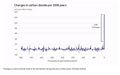 Changes in carbon dioxide per 1000 years - via Climate Central.jpg 682 × 424; 34 KB
 Citizens Climate Lobby - Save Our Future Act 2021.jpg 518 × 262; 77 KB
 Climate Action 25th conf in Madrid.jpg 680 × 510; 22 KB
 Climate activist - Steven Schmidt - 1978 on.png 600 × 480; 174 KB
 Climate Books - 2020.jpg 800 × 450; 69 KB
 Climate Change Conf Nov 6-17.png 464 × 488; 107 KB
 Climate Change COP27 - Nov 11 2022 US Representatives.jpg 712 × 444; 54 KB
 Climate Change COP27 - Nov 11 Kathy Castor.jpg 712 × 710; 77 KB
 Climate change is not moving at a glacial pace.png 448 × 532; 217 KB
 Climate Change US EPA.jpg 600 × 703; 95 KB
 Climate Conferences 1979-2020.jpg 768 × 768; 121 KB
 Climate Crisis - Emily Atkin Heated No. 1.jpg 537 × 453; 61 KB
 Climate Crisis and the Global Green New Deal.jpg 293 × 418; 33 KB
 Climate debate.jpg 493 × 580; 129 KB
 Climate Desk.jpg 390 × 226; 21 KB
 Climate Emergency Institute - Oct 2022.png 610 × 600; 274 KB
 Climate Emergency Institute -- 2021.jpg 800 × 450; 55 KB
 Climate emergency.jpg 800 × 450; 69 KB
 Climate Headline News around the World - July 2023.jpg 600 × 704; 151 KB
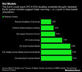 Climate Models.png 639 × 558; 123 KB
 Climate News - Oct 28 2022.jpg 626 × 600; 88 KB
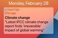
 Climate News - United Nations Report - Feb 2022.png 768 × 878; 539 KB
 Climate News Dec 4 2023 in Dubai.png 800 × 1,037; 649 KB
 Climate Plans Enforcement - Resources - GreenPolicy.png 768 × 897; 686 KB
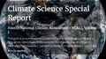 Climate Science Special Report - US - November 2017.jpg 800 × 445; 122 KB
 Climate strike - Week 171.png 739 × 600; 834 KB
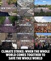 Climate Strike Around the World - Sep20,2019.jpg 700 × 830; 119 KB
 Climate Summit - Leonardo DiCaprio.png 600 × 663; 521 KB
 Climate Summit live updates - Nov 2 2021.png 751 × 600; 420 KB
 Climate Summit planned-1.jpg 800 × 301; 53 KB
 Climate Summit planned-2.jpg 800 × 187; 31 KB
 Climate Summit planned-3.jpg 800 × 278; 44 KB
 Climate Summit planned-4.jpg 800 × 241; 41 KB
 Climate usa 60 years on.jpg 800 × 480; 34 KB
 ClimateNews 360.jpg 172 × 172; 9 KB
 ClimateNewsFlorida.jpg 448 × 191; 36 KB
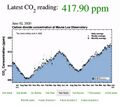 CO2 at Mauna Loa data - June 02, 2020 - 417.90 ppm.jpg 640 × 566; 66 KB
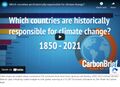 CO2 cumulative emissions 1850 - 2021 - countries.jpg 640 × 462; 211 KB
 CO2 Emissions per Capita by Country 1960-2014.png 800 × 451; 424 KB
 CO2 emissions-around-the-world.png 800 × 595; 123 KB
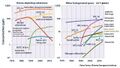
 CO2 global pathways via IPCC AR6 - how will we respond.jpg 800 × 450; 57 KB
 CO2 higher than in the past 5 million yrs.jpg 514 × 285; 62 KB
 COP26 Climate Summit concludes.jpg 600 × 800; 160 KB
 COP26 concludes - 2.png 648 × 467; 177 KB
 COP26 concludes - 3.png 648 × 713; 416 KB
 COP26 concludes.png 648 × 528; 329 KB
 COP26 in GLASGOW - 31 OCT-12 NOV 2021.jpg 800 × 264; 51 KB
 COP27 'opening speech'.png 640 × 460; 160 KB
 COP28 News - Dec 13 2023.png 800 × 898; 410 KB
 Coral bleaching - August 2023.png 488 × 430; 261 KB
 Coral bleaching - NOAA - August 2023.png 488 × 338; 201 KB
 Covering Climate Now.jpg 493 × 498; 67 KB
 Cradle of Civilization - and climate change.jpg 640 × 360; 70 KB
 Cumulative CO2 Emissions by Country Since 1850.png 800 × 445; 445 KB
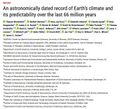 Dated record of Earths climate - Science Report Sept 10 2020.jpg 735 × 669; 192 KB
 Defend Our Future 6-1-2020.jpg 585 × 458; 103 KB
 Democratic Climate Plan-Introduced June 2020.jpg 528 × 561; 117 KB
 Democratic National Convention-62 climate speakers.jpg 443 × 407; 57 KB
 Democratic Party pres candidates debate in Miami-June 2019.jpg 800 × 534; 124 KB
 Democratic presidential candidates on the Green New Deal.jpg 800 × 359; 57 KB
 Denying human-caused climate change.jpg 639 × 620; 129 KB
 Earth Day 2021 - Climate Summit News-1.jpg 491 × 270; 127 KB
 Earth Day 50 years on.jpg 480 × 548; 107 KB
 Earth Science from Space-Monitoring Ice Melt.jpg 657 × 373; 60 KB
 Earth Science Research from Space.png 800 × 256; 208 KB
 Earth Summit 1992-s.png 336 × 418; 283 KB
 Earth Summit 1992.jpg 600 × 746; 171 KB
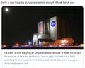 Earth trapping unprecedented amount of heat - NASA.jpg 468 × 373; 56 KB
 Earth-upper-atmosphere-NASA.jpg 800 × 781; 327 KB
 EarthScience Missions via the EOS - 2022.png 800 × 219; 139 KB
 Economist.com global capital snapshot as of July 2020.jpg 800 × 477; 119 KB
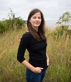 Elizabeth Rush.jpg 394 × 453; 47 KB
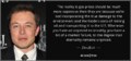 Elon Musk quote - gas externality price.png 680 × 320; 199 KB
 Emissions graph - gleick tw 2018.jpg 640 × 364; 37 KB
 Energy Charter Treaty.jpg 512 × 480; 74 KB
 Environment and Security.jpg 289 × 34; 16 KB
 Environmental laws in US - Supreme Court votes soon.png 800 × 414; 334 KB
 EPA website a 'ghost page' now.png 667 × 233; 45 KB
 ESA Living Planet Symposium - Announcement.png 637 × 600; 508 KB
 ESA Living Planet Symposium - May 2022.png 700 × 600; 258 KB
 ESA re ice loss - April 2023.png 640 × 432; 213 KB
 ESG Fight - Feb 2023.png 396 × 194; 88 KB
 EU agrees to cut emissions 55 percent by 2030.jpg 800 × 558; 96 KB
 EU unveils new climate change policy - July 14 2021 - 1.jpg 800 × 234; 33 KB
 EU unveils new climate change policy - July 14 2021 - 2.jpg 800 × 552; 86 KB
 EU unveils new climate change policy - July 14 2021 - 3.jpg 800 × 549; 89 KB
 EU unveils new climate change policy - July 14 2021 - 4.jpg 800 × 550; 92 KB
 EU unveils new climate change policy - July 14 2021 - 5.jpg 800 × 548; 88 KB
 EU unveils new climate change policy - July 14 2021 - 6.jpg 800 × 557; 89 KB
 EU unveils new climate change policy - July 14 2021 - 7.jpg 800 × 553; 92 KB
 EU unveils new climate change policy - July 14 2021 - 8.jpg 800 × 589; 91 KB
 ExxonMobil CO2 climatic response study - Graphic 1 - 1982.png 537 × 680; 150 KB
 ExxonMobil CO2 climatic response study - Graphic 2 - 1982.png 537 × 605; 112 KB
 Foley on March29,2017.png 487 × 135; 0 bytes
 From 1968 to 1992 -- and the Journey continues....png 572 × 851; 320 KB
 GCAS original.png 800 × 504; 94 KB
 GCAS-2.jpg 800 × 450; 136 KB
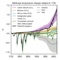 GHG forcings 1750-2020.png 531 × 531; 94 KB
 GHG ppt concentrations 1975-2020.jpg 640 × 361; 69 KB
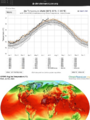
 Gistemp 1979-2019.png 750 × 491; 335 KB
 Glasgow-Climate Conference News-Nov 6, 2021.png 600 × 800; 290 KB
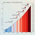
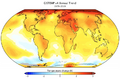
 Global Changes in temperature 1850-2020.jpg 480 × 480; 152 KB
 Global climate conferences and GHG increases.jpg 793 × 801; 56 KB
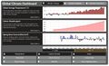
 Global Climate Dashboard - NOAA - Climate.gov.png 630 × 480; 165 KB
 Global climate dashboard-NOAA climate.gov.jpg 521 × 221; 45 KB
 Global climate dashboard-www.climate.gov.jpg 800 × 489; 100 KB
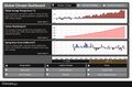 Global Climate Dashboard.jpg 800 × 529; 101 KB
 Global Climate Strike - RU.jpg 450 × 804; 116 KB
 Global fossil fuel emissions - in a lifetime graphic.png 600 × 657; 233 KB
 Global greenhouse gas emissions - 1980 - 2020.png 640 × 480; 158 KB
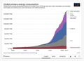 Global Primary Energy Consumption - 1800-2017.jpg 800 × 583; 65 KB
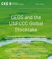 Global Stocktake, the first GST.jpg 800 × 905; 513 KB
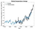
 Global temperature change 1850-2016.gif 512 × 288; 1.38 MB
 Global temperature change 1901-2000.jpg 640 × 508; 47 KB
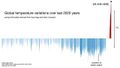 Global temperature variations over past 200 years.jpg 640 × 360; 29 KB
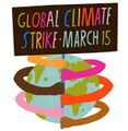 GlobalClimateStrike-March15,2019.jpg 600 × 613; 30 KB
 GND next steps.png 567 × 660; 304 KB
 Green New Deal, work in progress.jpg 800 × 450; 62 KB
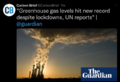
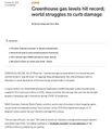 Greenhouse gas levels hit record - Reuters.jpg 600 × 696; 104 KB
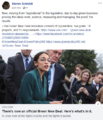
 Greta - the politics thats needed.jpg 639 × 203; 38 KB
 Greta anger into action.png 800 × 419; 528 KB
 Greta Looks Back.PNG 504 × 437; 368 KB
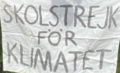 Greta Thunberg - Week 203 Climate Strike Banner.png 209 × 127; 51 KB
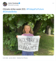 Greta Thunberg - Week 203 Climate Strike.png 554 × 601; 488 KB
 Historic climate-clean energy vote in US Congress August 12 2022.jpeg 800 × 775; 384 KB
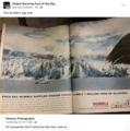 Historic photographs - Humble Oil TX - Exxon.png 591 × 596; 548 KB
 Hourglass-sand-2.jpg 450 × 342; 12 KB
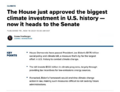 House passes biggest climate investment in U.S. history.png 625 × 480; 114 KB
 Huge heat anomaly in 2023 - by Gavin Schmidt.png 735 × 857; 172 KB
 Hurricanes - Typhoons via NASA data.png 764 × 924; 1,022 KB
 I Am Greta - the Documentary.jpg 387 × 485; 30 KB
 I Am Greta Marching.jpg 800 × 534; 80 KB
 I've done all I can.png 584 × 101; 19 KB
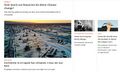
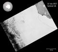 Iceberg breaks off from Antarctica photo from ESA July 12, 2017.jpg 860 × 768; 116 KB
 Icebergia Time July 12, 2017.png 613 × 673; 135 KB
 Icebergia-2.0.png 800 × 286; 362 KB
 Icebergia-2.png 1,343 × 480; 509 KB
 ICESAT mission.png 640 × 271; 319 KB
 IEA - Support for Fossil Fuels - re 2021.jpg 559 × 800; 143 KB
 IEA News 1.jpg 480 × 400; 64 KB
 IEA News 2.jpg 480 × 475; 55 KB
 IEA News 3.jpg 480 × 496; 57 KB
 IEA News 4.jpg 480 × 530; 57 KB
 IEA News 5.jpg 480 × 539; 62 KB
 Inhofe and the Snowball.png 640 × 329; 396 KB
 IPCC Report - Feb 2022.jpg 448 × 291; 113 KB
 IPCC report August 9-2021 (1).jpg 745 × 380; 156 KB
 IPCC report August 9-2021 (2).jpg 745 × 428; 171 KB


.jpg)
.jpg)